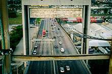
Danziger Bridge
| Danziger Bridge | |
|---|---|
 Traffic on Danziger Bridge, 2012 | |
| Carries |
|
| Crosses | Industrial Canal |
| Locale | New Orleans, Louisiana |
| Preceded by | Danziger Bridge |
| History | |
| Construction begin | 1983 |
| Construction end | 1987 |
| Opened | February 1988 |
The Danziger Bridge is a vertical lift bridge named after a New Orleans lawyer and businessman,[1] which carries seven vehicular lanes of U.S. Route 90 (Chef Menteur Highway) across the Industrial Canal in New Orleans, Louisiana. It was built to replace the old Danziger Bridge, a draw bridge constructed in 1931–1932. The current Danziger Bridge was constructed on the south side of the old bridge between 1983 and 1987, officially opening in February 1988, becoming the widest lift bridge in the world.[2] Most marine traffic is accommodated in the down position.
Attorney Alfred Danziger, a member of a prominent New Orleans Jewish family, served as personal attorney for Governor Huey Long, as well as assistant attorney general in 1934, and executive counsel for Mayor Robert Maestri from 1936-1946.[3] He was also a principal fundraiser for the historically black Dillard University which was founded in 1930 by merging Straight University and other African American serving institutions.[4]
In 2005, the bridge was the site of the Danziger Bridge shootings, in which two unarmed civilians were killed by members of the New Orleans Police Department. 4 other civilians were also wounded.
See also
-
 Bridges portal
 -
 Louisiana portal
 -
 New Orleans portal
References
- ↑ Laura Maggi, "Family members of Danziger Bridge's namesake say its name will resonate in history," New Orleas Times-Picayune, Sept. 26, 2011.
- ↑ Campanella, Catherine (2013). "Legendary Locals of Metairie". Arcadia Publishing. p. 28. Retrieved December 1, 2015.
- ↑ , Blake Pontchartrain, "Why is the bridge over the Industrial Canal Called the Danziger Bridge," Bestofneworleans.com, Gambit, September 25, 2007.
- ↑ , "Chris Rose: Who was Alfred Danziger?", ProjectNOLA.com, August 3, 2011.
| Wikimedia Commons has media related to Danziger Bridge. |
Coordinates: 30°0′30″N 90°1′38″W / 30.00833°N 90.02722°W