Tornado debris signature
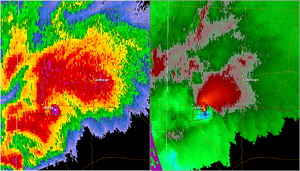
A tornadic debris signature (TDS), often colloquially referred to as a debris ball,[1] is an area of high reflectivity on weather radar caused by debris lofting into the air, usually associated with a tornado.[1][2] A TDS may also be indicated by dual-polarization radar products, designated as a polarimetric tornado debris signature (PTDS). Polarimetric radar can discern meteorological and nonmeteorological hydrometeors and the co-location of a PTDS with the enhanced reflectivity of a debris ball are used by meteorologists as confirmation that a tornado is occurring.[3]
Background
Debris balls can be a result of anthropogenic or biomass debris and are more likely to occur if a tornado crosses a "target-rich" environment such as a forest or populated area. A TDS is most likely to be observed when a tornado is closer to a radar site and the farther away from the radar that a TDS is observed the more likely that the tornado is stronger. As a result of the strong winds required to damage structures and loft debris into the air, debris balls are normally the result of EF3 or stronger tornadoes on the Enhanced Fujita Scale. Weaker tornadoes may also not cause debris balls due to their mostly short-lived nature and thus any debris may not be sampled by radar.[4] However, not all tornadoes meeting such strength requirements exhibit debris balls, depending on their vicinity to sources of debris and distance from the radar site.[1] A debris ball on radar images can verify tornadoes 70–80% of the time.[5]
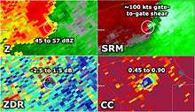
Debris balls are seen on radar reflectivity images as a small, roundish area of high reflectivity values. Research conducted on debris balls that were noted during the 2011 Super Outbreak suggested that horizontal reflectivity from debris balls ranged from 51 to 72 dBZ during those outbreaks. Reflectivity values also decreased with increasing height.[1] Due to the irregular and variable size, shapes, and tumbling nature of tornadic debris, debris balls typically produce a correlation coefficient (ρhv) less than 0.80. Differential reflectivity (ZDR) values associated with debris balls are normally near or below 0 dB. Debris balls are almost always associated with a strong velocity couplet and the corresponding algorithm based detection, the tornado vortex signature (TVS) or tornado detection algorithm (TDA).[6]
See also
References
- 1 2 3 4 Bunkers, Matthew J.; Baxter, Martin A. (August 23, 2011). "Radar Tornadic Debris Signatures on 27 April 2011" (PDF). National Weather Service. Retrieved 31 December 2012.
- ↑ "Severe Weather & Flooding Event of March 3, 2012; Lowndes-Lanier Co. EF3 Tornado". Tallahassee, Florida: National Weather Service. Retrieved 31 December 2012.
- ↑ "Tornadic Debris Signature from Dual Polarization Radar". NWS Birmingham, AL. October 3, 2012. Retrieved 2014-05-12.
- ↑ Ryzhkov, Alexander V.; Schuur, Terry J.; Burgess, Donald W.; Heinselman, Pamela L.; Giangrande, Scott E.; Zrnic, Dusan S. (2005). "The Joint Polarization Experiment: Polarimetric Rainfall Measurements and Hydrometeor Classification" (PDF). B. Am. Meteorol. Soc. 86 (6): 809–24 [821]. Bibcode:2005BAMS...86..809R. doi:10.1175/BAMS-86-6-809. Retrieved 31 December 2012.
- ↑ Weinberg, Marc (March 19, 2012). "Learning About Weather Radar ... The Debris Ball". WDRB.com. Retrieved 31 December 2012.
- ↑ Schlatter, Paul. "Dual-Pol Radar Applications: Tornadic Debris Signatures". National Oceanic and Atmospheric Administration. Retrieved 31 December 2012.
External links
- Dual-Polarization Radar Training for NWS Partners including Tornado Debris Signature module by the NWS Warning Decision Training Branch (WDTB)
- Van Den Broeke, Matthew S.; S. T. Jauernic (2014). "Spatial and Temporal Characteristics of Polarimetric Tornadic Debris Signatures". J. Appl. Meteor. Climatol. 53 (10): 2217–31. Bibcode:2014JApMC..53.2217V. doi:10.1175/JAMC-D-14-0094.1.
- Bodine, David J.; R. D. Palmer; G. Zhang (2014). "Dual-Wavelength Polarimetric Radar Analyses of Tornadic Debris Signatures". J. Appl. Meteor. Climatol. 53 (2): 242–61. Bibcode:2014JApMC..53..242B. doi:10.1175/JAMC-D-13-0189.1.