Deltana Platform
The Deltana Platform lies offshore, on the platform of the Orinoco delta about 90 km northeast of the island Tobejuba in the state Delta Amacuro, and approximately 233 km southeast of Güiria, Sucre State, Venezuela.
Water Depths and Topografhy of Bottom
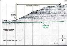
The water depths range from about 66 m in the southwest up to 308 m in the northeast, with an average slope of approximately 0.4% (0.25 grades) to the east-northeast. The relief of the seabed is generally irregular and includes frequent scarps related with faulting and erosion.[1]
Geology
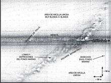
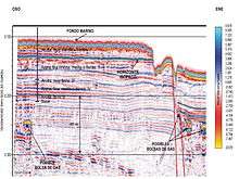
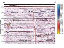
The seabed in general is composed mainly of very soft clays. The geologic features in this area include normal faults with northwest-southeast orientation, a system of exposed and buried reefs that cross the area from the
northwest toward the southeast, gas pockets trapped in faults and shallow strata at different levels of depth, paleo-channels, abrupt erosional slopes and scarps associated with submarine debris flows and faulting. Several side scan sonar targets are interpreted as scattered small debris.[2]
References
- ↑ Imbrie, J. y Van Andel, TH. (1964), “Vector analysis of heavy mineral data”. Geol. Soc. Am. Bull., 75 (11): 1131 – 1156.
- ↑ Deiros, D. Sackett, D. Malavé, G , Study of the shallow geological conditions, seabed and its potential impact for the development of the exploitation of natural gas in the Venezuelan Plataforma Deltana Geophysical Congress, Caracas (2002).