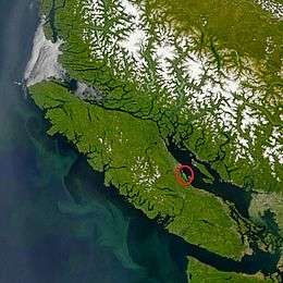
Denman Island
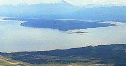 Denman Island looking south from Comox | |
 | |
| Geography | |
|---|---|
| Location | Strait of Georgia |
| Coordinates | 49°33′N 124°48′W / 49.550°N 124.800°WCoordinates: 49°33′N 124°48′W / 49.550°N 124.800°W |
| Archipelago | Gulf Islands |
| Area | 51.03 km2 (19.70 sq mi) |
| Administration | |
| Province | British Columbia |
| Regional district electoral area | Comox Valley A |
| Demographics | |
| Population | 1016 (2001) |
Denman Island is one of the Northern Gulf Islands and part of the Comox Valley Regional District of British Columbia, Canada, and is home to a small community of 1,022 year-round residents.[1]
History
Denman Island was first inhabited by Indigenous peoples including the Pentlatch and Sliamon as evidenced by middens, gravesites, and oral history. It was discovered and mapped by Europeans during the 1791 voyage of the Spanish ship Santa Saturnina, under Juan Carrasco and José María Narváez. It was named by Captain Richards in 1864 for Rear Admiral Joseph Denman who was commander of the Pacific station from 1864 to 1866.[2]
Denman Island life
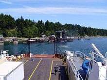
Regular ferry service links Denman Island to both Hornby Island from Gravelly Bay on the east side of Denman and across Baynes Sound to Buckley Bay on Vancouver Island on the west side. Denman Island has long been a haven for people escaping from busy urban centres. Downtown Denman consists of one general store (which includes a gas pump, government liquor outlet, and post office), a hemp clothing store, hardware store, bookstore, dental bus (shared with Hornby two weeks a month), craft stores, the Guest House Bistro, a cafe, two real estate offices, an insurance brokerage, two community halls, the Dora Drinkwater Volunteer Library, a community school, a church, and the museum. It is famous for its all ages dances, festivals, quiet roads, and beautiful scenery. Yoga is a prominent activity, as is gardening, and volunteerism. Many artists have made Denman Island their home for decades, and as a result there is a thriving local artistic community. The island has a land area of 51.03 square kilometres (19.70 sq mi).
Complementing a population made up of farmers, retired baby-boomers, artists, craftspeople and a laid-back collection of alternative types are young homesteaders from various origins. The author Emily St. John Mandel was born and brought up on Denman Island.[3]
Vegetation and soils
Much of the western part of Denman Island is covered by a dense forest dominated by Douglas fir, western hemlock, and western red cedar on deep gravelly loam glacial till. Some areas have shallow soils over sandstone or shale. The eastern part has a loamy sand on which arbutus is frequently present. All of these soils were classed as brown podzolic in a 1959 soil survey.
Provincial Parks located on Denman Island
- Sandy Island Marine Provincial Park (off northern tip, accessible on foot at low tide).
- Fillongley Provincial Park – B.C. Ministry of Environment Site
- Boyle Point Provincial Park – B.C. Ministry of Environment Site
Local media
Denman Island has a monthly news and artistic journal called the Flagstone, a weekly news and advertising circular called the Grapevine, a community radio station, and several active online groups, including the Denman Island Open Bulletin Board.
References
- ↑ 2011 Canada Census
- ↑ "Denman Island". BC Geographical Names.
- ↑ Kirch, Claire (9 March 2012). "Emily St. John Mandel: Once a Dancer, Now a Noir Phenom". Publishers Weekly. Retrieved 30 September 2015.
Further reading
- Day, J.H., L. Farstad, and D.G. Laird, 1959. Soil Survey of Southeast Vancouver Island and Gulf Islands, British Columbia. B.C. Soil Survey, Rept. No. 6, Can. Dept. Agric.
- Denman Island Trust Area, Comox-Strathcona K Regional District Electoral Area, British Columbia; Statistics Canada
External links
| Wikimedia Commons has media related to Denman Island. |