Rollins Pass
| Rollins Pass | |
|---|---|
|
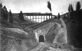
Riflesight Notch railroad trestle on the way up Rollins Pass in 1903. | |
| Elevation | 11,660 ft (3,554 m)[1] |
| Traversed by | Unpaved road, natural gas pipeline |
| Location | Boulder, Gilpin, Grand counties, Colorado, U.S. |
| Range | Front Range |
| Coordinates | 39°56′03″N 105°40′58″W / 39.93417°N 105.68278°WCoordinates: 39°56′03″N 105°40′58″W / 39.93417°N 105.68278°W[1] |
| Topo map | USGS East Portal |
 Colorado | |
|
Rollinsville and Middle Park Wagon Road / Denver, Northwestern and Pacific Railway Hill Route Historic District | |
| Area | 436.3 acres (176.6 ha) |
| Built | 1903 |
| Built by | Denver, Northwestern and Pacific R.R. |
| NRHP Reference # | 80000881, 97001114[2] |
| Added to NRHP | September 30, 1980 |
Rollins Pass, elevation 11,660 ft (3,550 m), is a mountain pass in the Rocky Mountains of north-central Colorado in the United States. The pass is located on and traverses the continental divide at the crest of the Front Range southwest of Boulder, and is at the boundaries of Grand, Gilpin, and Boulder counties. The pass provides a route over the Continental Divide between the Atlantic Ocean watershed of South Boulder Creek (in the basin of the South Platte River) with the Pacific Ocean watershed of the Fraser River, a tributary of the Colorado River.
Rollins Pass was added to the National Register of Historic Places in 1997.[2]


Description
Rollins Pass (also known as Corona Pass) sits approximately five miles east and opposite the popular ski area in Winter Park, and is in the general location between Winter Park and Rollinsville. The Boulder Wagon Road (BWR), which predates the rail route, employed much of what would later become Rollins Pass. The pass is traversed by two unpaved roads, mostly the former roadbed of the Denver, Northwestern, and Pacific Railway, that later became the Denver and Salt Lake Railway. This high altitude or 'hill route' railroad was known as the Moffat Road and this route was replaced (and subsequently abandoned) by the opening of the Moffat Tunnel in 1928; subsequent to the opening of the new route, the rails and ties were removed in 1935.[3][4]

The majority of the route of the Moffat Road is open, except for a long, deteriorated trestle (Riflesight Notch trestle) just east of the pass, and sections leading to the Needle's Eye Tunnel, a short high altitude railroad tunnel which was closed in 1990 after a rock fell from the ceiling injuring a Denver firefighter resulting in a below-knee amputation.[5] Since then, the tunnel was sealed by Boulder County and the United States Forest Service. The original Boulder Wagon Road (BWR) also goes over Rollins Pass yet bypasses the Needle's Eye Tunnel (as it had not yet been constructed) by taking a steep route encircling Yankee Doodle Lake counterclockwise before continuing to head west/northwest to proceed over the summit and down into the Middle Park valley. The BWR is a four-wheel-drive road not suited to lower clearance two-wheel-drive vehicles, and in some areas a winch can be helpful. Although open prior to 2008 and in good condition, this road remains to this day a subject of much controversy. In 2002 the James Peak Wilderness and Protection Area Bill (a.k.a. Public Law 107-216) was passed by Congress and signed into law by President George W. Bush. The Bill specifically created a narrow road corridor between the Indian Peaks and James Peaks Wilderness areas and states that if any of the affected counties (Grand, Gilpin or Boulder) request, the Secretary of the USDA will cooperate and assist with the repair of the Rollins Pass Road and until that time the attendant road (the BWR) will remain open to motorized use. Boulder County officials and the USFS-Boulder Ranger District have resisted the wording of the law and have closed the BWR. Both Grand and Gilpin Counties have made numerous written requests to the Secretary for the repair of Rollins Pass Road but to date there has been no repair of the road or the barricaded Needle's Eye Tunnel. The reopening of the BWR, and/or repair of the Rollins Pass Road, and even the facts surrounding the 1990 accident in the tunnel, have become contentious and ongoing issues.
Rollins Pass is a popular recreational location for its spectacular views, wildflowers, hiking, and photography during the summer months. The road up to the pass on the western side from Winter Park is in fair condition starting from U.S. Highway 40 in Winter Park, and can be traveled by regular 2WD (although 4WD high-clearance vehicles fare better) automobile in the summer in good weather, or by snowmobile in the winter. Official snowmobile tours (on the western, Winter Park side) follow much of the summer road from Arrow and terminate shortly after Sunnyside (located further uphill and past the Riflesight Notch trestle). However, the tour does not go higher than Ptarmigan Point and does not reach the summit in the winter. While Rollins Pass is open for vehicular summer traffic from June 15 through November 15 each year, it's generally not possible given average snowfall amounts to drive higher than Ptarmigan Point on the western side and Yankee Doodle Lake on the eastern side before early-mid July.[6] Winter snows make reaching these points impossible after early October. There are no facilities (neither water nor restrooms) on either side of the pass. Since usage of Rollins Pass is currently classified as 'heavy' by the United States Forest Service, parking can be limited at designated parking sites.[6]
The only access to the actual Rollins Pass from the east is via the disputed 4WD BWR due to the tunnel closure. From the Peak-to-Peak Highway (State Highway 119) at Rollinsville East Portal Road runs west, parallel to South Boulder Creek and the current Union Pacific Railroad tracks, to the entrance to the Moffat Tunnel at East Portal, and then rises on the abandoned railroad grade via the Moffat Road to the closed Needle's Eye Tunnel. From Rollinsville to East Portal, the road is an all-weather gravel road, with some chattery washboard sections, which can be traveled by regular automobiles. However, beyond East Portal (at the formal start of Rollins Pass road) the road becomes very rough due to lack of maintenance (see photograph below of road damage). Although not steep or loose, it is recommended that a high clearance 4WD vehicle be used. This section of road is open to just beyond Jenny Lake where there is a concrete barricade approximately one half mile before the Needle's Eye Tunnel. The road is open for hiking beyond the barricade to the entrance of the closed tunnel, and a rough trail continues above the tunnel for those on foot to bypass the closure.
History

Rollins Pass as a prehistoric Native American hunting ground
Native Americans were the first to utilize Rollins Pass as a natural, low crossing over the Continental Divide for the purposes of communal hunting of large game, including big-horn sheep and elk. There are more than 96 documented game drives, including the Olson Game Drive, found largely above timberline and near the summits of multiple mountain ridges. Handmade rock walls drove prey towards hunters waiting in blinds. These unique high-altitude constructs were built, refined, and continually used over millennia.[7] Currently the game drives are being studied by Colorado State University archaeology graduate students led by Dr. Jason M. LaBelle, associate professor, Department of Anthropology, Center for Mountain and Plains Archaeology, Colorado State University, Fort Collins.
The Olson Game Drive
The Olson site (5BL147) is a multi-component rock walled game drive and is but one part of a much larger game drive complex located on Rollins Pass. Byron Olson and James Benedict conducted work at the site in the late 1960s. Present-day archaeology teams built on Olson and Benedict's work to expand the overview of the site using modern techniques. As of 2013, at least 45 blinds as well as 1,307 meters of rock walls are present across the Olson site; the purposes of which were to funnel game upslope to waiting hunters. Both radiocarbon and lichenometric dating suggest occupation by Native Americans spanning the last 3200 years, with diagnostic tools suggesting even older use of the site.[8]
Rollins Pass as a toll wagon road
The first recorded use of the pass by a wagon train was in 1862. It is named for John Quincy Adams Rollins, who constructed a toll wagon road over the pass in the 1870s, providing a route between the Colorado Front Range and Middle Park. The pass was used heavily in the late 19th century by settlers to drive cattle over the continental divide to Middle Park, and at one time as many as 12,000 cattle at a time were driven over the pass.[9]
Rollins Pass as a railroad line

In the early 20th century, David Moffat, a Denver banker, established the Denver, Northwestern and Pacific Railway with the intention of building a railroad over the Front Range in the vicinity of the pass. The line was known as the Moffat Road, ran 23 miles over the pass, with a 4% grade along many stretches, and was one of the highest adhesion (non-cog) railroads ever constructed in North America. Along this route is the closed Needle's Eye Tunnel (not to be confused with lower and longer Moffat Tunnel constructed some 30 years later). Other notable landmarks on the route included Riflesight Notch, a one-and-one-half mile loop where trains crossed over a trestle, performed ~90 degree gradual turn to descend 150 feet, and passed through a tunnel underneath the trestle.[11] A small rail stop called Corona was established as a station at the top of the pass, with a restaurant and lodging, which allowed workers to help keep the rail line free of snow in the winter. Despite the fact that the line was enclosed in almost continuous snow sheds near the top of the pass, trains were often stranded for several days (and in some cases for up to 30 days)[12] during heavy winter snowstorms because the snow could fall through the wood planking of the sheds. Coal smoke and toxic gasses collected in the snow sheds causing temporary blindness, loss of consciousness, and sometimes death.[4][12] Workers on the Moffat Road had an adage: There's winter and then there's August.[4] It was these heavy snowstorms that led to the financial demise of the Moffat Road and served as the incentive for construction of a permanent railroad tunnel through the Rocky Mountains. Because the Rollins Pass route was intended to be temporary, it was constructed as cheaply as possible: using high trestles, 4% grades and switchbacks instead of high fills, iron bridges, and tunnels. Because of the high-altitude nature of the route, the route utilized wyes instead of turntables to turn locomotives around.
Numerous wrecks of Mallet locomotives and/or the loss of portions of rail manifests occurred on both sides of the pass:[11]
- Mallet #201: On a curve just above Antelope; East side
- Mallet #208: The Loop, near Riflesight Notch; West side
- Mallet #210: The Loop, near Riflesight Notch; West side
Much of the right-of-way is still intact, although some of the trestles have collapsed or have been destroyed (such as trestle #72.83 on the West side).[11] A small wye on the passing siding at the eastern portal of the Moffat Tunnel marks the spot where the Rollins Pass line would have merged into the modern route if it still existed. This rail is currently utilized for short-turning some modern services.
The first attempt to tunnel under Rollins Pass met with both engineering and financial failure, and its remains can still be seen on the northern slope of the rock wall at Yankee Doodle Lake. The detritus from the attempted excavation of the tunnel was placed at the northernmost part of the lake where a visible bump or bulge of pulverized granite can be seen rising out of the water.[4] The second attempt, to build a longer tunnel at a lower elevation and what would become Moffat Tunnel was better planned and financed. Although Moffat did not live to see his tunnel completed, his enterprise was continued under a different name, and the Moffat Tunnel opened just south of the pass on February 26, 1928. The new tunnel route became part of the mainline across Colorado of the Denver and Salt Lake Railroad, later the Denver and Rio Grande Railroad, and now the Union Pacific Railroad. The Moffat Tunnel continues to serve as the route for the Amtrak California Zephyr between Chicago, Illinois and Emeryville, California, and until summer 2009, for Ski Train passengers between Denver and Winter Park.
The tracks over Rollins Pass were not immediately dismantled after the Moffat Tunnel opened. In fact, they had to remain usable as an emergency route. It was used as such in July 1928 when several wooden planks inside the Moffat Tunnel collapsed. Permission to dismantle the rails on Rollins Pass was not granted by the ICC until 1935. Sometime in the seven years between when the line was abandoned and when the tracks were removed, a mysterious fire destroyed several snow sheds near the summit as well as the hotel at Corona Station.
Environment

Flora
Rollins Pass consists of several distinct floral environments including lodgepole pine and quaking aspen at lower elevations, and krummholz at tree line. Above tree line, the landscape consists largely of small perennial flowers, cryptobiotic soils, and alpine tundra. The latter being extremely fragile and if damaged, can take hundreds of years to recover.[13][14] Leaving the trail can cause erosion, land degradation, possible species extinction, and habitat destruction[14] and it is for these reasons ORVs are not allowed to leave the established road.
Fauna
The top predator in the area are black bears (Ursus americanus), generally below timberline; however, they occasionally venture above the krummholz. The bears prey on bighorn sheep (Ovis canadensis) and mountain goats (Oreamnos americanus), as well as yellow-bellied marmot (Marmota flaviventris) in the region. Above timberline, pikas (Ochotona princeps) are common. Below timberline, both elk (Cervus canadensis) and mule deer (Odocoileus hemionus) are common. The presence of migratory bighorn sheep and other large game is the reason why the Native Americans constructed the large and complex game drives on Rollins Pass.[8]
Among birds, the white-tailed ptarmigan (Lagopus leucurus) are present on Rollins Pass, especially above treeline. Their camouflage is effective against the exposed blocks of granite rendering them virtually invisible to the eye. Brown-capped rosy finches (Leucosticte australis), rock wrens (Salpinctes obsoletus), and pipits are also seen or heard at timberline and near the summit.
Climate

Due to high-elevation above timberline in a backcountry setting, there is neither lightning protection nor lightning mitigation from sudden thunderstorms resulting in a high-risk, extremely dangerous situation for visitors.[15]
While temperature, humidity, and other factors influence atmospheric pressure, the atmospheric pressure on the summit measures roughly 457 Torr (mmHg); while a standard atmospheric pressure measured at sea level is 760 Torr. At this pressure, many people, especially out-of-town sightseers and tourists, can suffer from rapid dehydration and altitude sickness, also known as acute mountain sickness.[16] Acute mountain sickness can progress to high altitude pulmonary edema (HAPE) or high altitude cerebral edema (HACE), which are potentially fatal.
Geology
The Front Range was created by the Laramide Orogeny, the last of three major mountain-building events, which occurred between 70 and 40 million years ago. Tectonic activity during the Cenozoic Era changed the Ancestral Rocky Mountains via block uplift, eventually forming the Rocky Mountains as they exist today. The geologic make-up of Rollins Pass and the surrounding areas were also affected by deformation and erosion during the Cenozoic Era. Many sedimentary rocks from the Paleozoic and Mesozoic eras exist in the basins surrounding the pass.
Today

Rollins Pass as a scenic dirt road
From 1955-1979, Rollins Pass served as a complete road over the mountain pass for automobiles until a rock fall in Needle's Eye tunnel in 1979 closed the path over the pass. In 1988, after several studies and structural strengthening of Needle's Eye was accomplished, the complete road was re-opened only to close permanently in 1990.
In popular culture
- Some ski runs (and one chairlift) at the nearby Winter Park Resort on the mountain of Mary Jane are named after features on Rollins Pass or are named after general railroad terminology: Trestle, Derailer, Rainbow Cut, Sidetrack, Brakeman, Roundhouse, Phantom Bridge, Sunnyside.
- Winter Park Resort's summer downhill mountain bike park is called Trestle
Recent events
On July 30, 2006, a single engine airplane on its way to Boulder crashed on Rollins Pass. The two occupants of the 1969 Citabria 7KCAB were killed on impact.[17]
See also
References
- 1 2 "Rollins Pass". Geographic Names Information System. United States Geological Survey. Retrieved 2013-05-18.
- 1 2 National Park Service (2010-07-09). "National Register Information System". National Register of Historic Places. National Park Service.
- ↑ Griswold, P.R. "The Moffat Road"
- 1 2 3 4 Bollinger, Edward, "Rails that climb"
- ↑ http://dbeasy.net/CindyCharltonSpeaks/pdfs/Fall2005_Newsletter.pdf
- 1 2 http://www.fs.usda.gov/recarea/arp/recreation/recarea/?recid=28586&actid=51
- ↑ http://www.skyhidailynews.com/news/15606499-113/presentation-explores-hunting-practices-of-native-americans
- 1 2 LaBelle, Jason M. & Pelton, Spencer R. "Communal hunting along the Continental Divide of Northern Colorado: Results from the Olson game drive (5BL147)", 2013
- ↑ "Rollins Pass and the Moffat Tunnel". EllensPlace.net. 1928-02-26. Retrieved 2013-04-29.
- ↑ http://digitalcollections.ppld.org/cdm/singleitem/collection/p15981coll28/id/266/rec/1
- 1 2 3 Bollinger, E. T. & Crossen, Forrest "The Moffat Road (Former 'Hill' Route): A Self-Guiding Auto Tour"
- 1 2 http://www.rockymtnrrclub.org/Personal%20History%20Vault/Frank%20Arbuckle.pdf
- ↑ http://www.nps.gov/romo/learn/nature/alpine_tundra_ecosystem.htm
- 1 2 http://www.staythetrail.org/index.php?option=com_k2&view=itemlist&layout=category&task=category&id=6&Itemid=155#faqnoanchor
- ↑ http://rendezvous.nols.edu/files/Curriculum/research_projects/lightning-risk-management-brochure.pdf
- ↑ http://www.climbing-high.com/dehydration.html
- ↑ EndPlay. "Corona Pass Plane Crash Kills 2, UPDATED: 7:48 am MDT July 31, 2006". TheDenverChannel.com. Retrieved 2013-04-29.
External links
- Official web site of the Denver & Salt Lake Historical Society and the Rollins Pass Restoration Association
- Topographic map
- Artist renderings of what Rollins Pass was like
- Rollins Pass and the Moffat Tunnel
- Satellite Image of Needle's Eye Tunnel

| Topics | |
|---|---|
| Lists by states |
|
| Lists by insular areas | |
| Lists by associated states | |
| Other areas | |
| |