Devil's Peak Estate
| Devil's Peak Estate | |
|---|---|
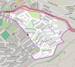
 Street map of Devil's Peak Estate | |
  
| |
|
Location within Cape Town  | |
| Coordinates: 33°56′12″S 18°25′49″E / 33.9368°S 18.4302°ECoordinates: 33°56′12″S 18°25′49″E / 33.9368°S 18.4302°E | |
| Country | South Africa |
| Province | Western Cape |
| Municipality | City of Cape Town |
| Main Place | Cape Town |
| Area[1] | |
| • Total | 0.46 km2 (0.18 sq mi) |
| Population (2011)[1] | |
| • Total | 1,859 |
| • Density | 4,000/km2 (10,000/sq mi) |
| Racial makeup (2011)[1] | |
| • Black African | 8.5% |
| • Coloured | 8.2% |
| • Indian/Asian | 2.7% |
| • White | 77.8% |
| • Other | 2.7% |
| First languages (2011)[1] | |
| • English | 72.2% |
| • Afrikaans | 18.9% |
| • Other | 8.9% |
| Postal code (street) | 8001 |
Devil's Peak Estate is a suburb of Cape Town, South Africa in the area known as the City Bowl. It is sandwiched between Vredehoek and Zonnebloem on the slopes of Devil's Peak. According to the 2011 census it has a population of 1,859 residents in an area of 0.46 square kilometres (0.18 sq mi).[1]
Devil's Peak is situated adjacent to the M3 expressway (De Waal Drive). It is served by route 101 of the MyCiTi bus service.
References
This article is issued from Wikipedia - version of the 10/2/2016. The text is available under the Creative Commons Attribution/Share Alike but additional terms may apply for the media files.
.svg.png)