Devil's Water
| Devil's Water | |
 Devil's Water | |
| Country | United Kingdom |
|---|---|
| County | Northumberland |
| Mouth | |
| - coordinates | 54°58′29″N 2°02′22″W / 54.9746°N 2.0395°WCoordinates: 54°58′29″N 2°02′22″W / 54.9746°N 2.0395°W |
| Length | 26.3 km (16 mi) |
 Location within Northumberland
| |
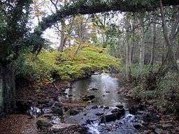
Devil's Water is a river in Northumberland, England. A tributary of the River Tyne it joins that river from the south, near the village of Dilston about 1 mile (1.6 km) south-west of Corbridge. It is formed from the waters of several smaller burns and sikes between Embley and Hackford some 5 miles (8 km) to the south of Hexham.[1][2][3]
Its tributaries include Rowley Burn and West Dipton Burn.[2]
Devil's Water is of historical interest, figuring in the Battle of Hexham.
References
- ↑ "Devil's Water". The UK Rivers Guidebook. 2000-01-01. Retrieved 14 April 2016.
- 1 2 "Devils Water from Rowley Burn to Tyne". Catchment Data Explorer. Environment Agency. Retrieved 14 April 2016.
- ↑ "Devils Water from Source to Rowley Burn". Catchment Data Explorer. Environment Agency. Retrieved 14 April 2016.
This article is issued from Wikipedia - version of the 4/22/2016. The text is available under the Creative Commons Attribution/Share Alike but additional terms may apply for the media files.