Diurnal temperature variation

In meteorology, diurnal temperature variation is the variation between a high temperature and a low temperature that occurs during the same day.
Temperature lag
Temperature lag is an important factor in diurnal temperature variation: peak daily temperature generally occurs after noon, as air keeps net absorbing heat even after noon, and similarly minimum daily temperature generally occurs substantially after midnight, indeed occurring during early morning in the hour around dawn, since heat is lost all night long. The analogous annual phenomenon is seasonal lag.
As solar energy strikes the earth’s surface each morning, a shallow 1–3-centimetre (0.39–1.18 in) layer of air directly above the ground is heated by conduction. Heat exchange between this shallow layer of warm air and the cooler air above is very inefficient. On a warm summer’s day, for example, air temperatures may vary by 16.5 °C (30 °F) from just above the ground to waist height. Incoming solar radiation exceeds outgoing heat energy for many hours after noon and equilibrium is usually reached from 3–5 p.m. but this may be affected by a variety of different things such as large bodies of water, soil type and cover, wind, cloud cover/water vapor, and moisture on the ground.[1]
Differences in variation
Diurnal temperature variations are greatest very near the earth’s surface.
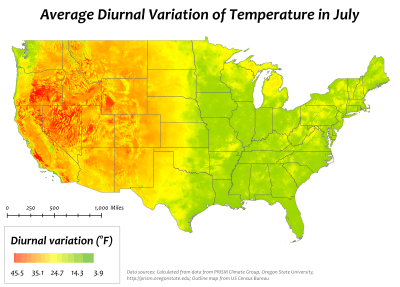
High desert areas typically have the greatest diurnal temperature variations. Low lying, humid areas typically have the least. This explains why an area like the Snake River Plain can have high temperatures of 38 °C (100 °F) during a summer day, and then have lows of 5–10 °C (41–50 °F). At the same time, Washington D.C., which is much more humid, has temperature variations of only 8 °C (14 °F);[1] urban Hong Kong has a diurnal temperature range of little more than 4 °C (7.2 °F).
While the National Park Service claimed that the world record is a variation of 102 °F (56.7 °C) (from 46 °F or 7.8 °C to −56 °F or −48.9 °C) in Browning, Montana in 1916,[2] the Montana Department of Environmental Quality claimed that Loma, Montana also had a variation of 102 °F (56.7 °C) (from −54 °F or −47.8 °C to 48 °F or 8.9 °C) in 1972.[3]
Viticulture
Diurnal temperature variation is of particular importance in viticulture. Wine regions situated in areas of high altitude experience the most dramatic swing in temperature variation during the course of a day. In grapes, this variation has the effect of producing high acid and high sugar content as the grapes' exposure to sunlight increases the ripening qualities while the sudden drop in temperature at night preserves the balance of natural acids in the grape.[4]
See also
References
- 1 2 M. Hackworth "Weather & Climate" course notes, with prior permission
- ↑ Weather - Glacier National Park
- ↑ Montana Department of Environmental Quality (DEQ) - FAQ
- ↑ J. Robinson "The Oxford Companion to Wine" Third Edition pg 691 Oxford University Press 2006 ISBN 0-19-860990-6