Djerid
This article is about natural region. For a type of spear, see Djerid (weapon).
| Djerid الجريد | |
|---|---|
| Natural region | |
|
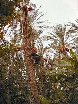
Palms in Tozeur | |
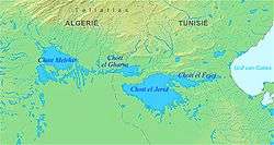 Map of the Chott el Djerid area | |
| Country | Algeria, Libya and Tunisia |
el-Djerid, al-Jarīd (Arabic: الجريد; "Palm Leaf", Darija l-Jrīd) is a semidesert natural region comprising southern Tunisia and adjacent parts of Algeria and Libya.
Geography
The region is characterised by bare pink hills with oases and several chotts (salt pans) such as Chott el Djerid in Tunisia.[1] Economically the area is important for phosphate mining. Major towns include Gafsa and Tozeur.
It remains the principal center of Ibāḍism in North Africa, with remaining Ibāḍī communities on Djerba in Tunisia, in the M'zab in Algeria, and in Jabal Nafusa in Libya. In medieval times, it often formed a politically separate entity under the control of Ibāḍī imams.
See also
References
- ↑ "البحيرة شط ايل الجريد - تونس". Tixik.com. Retrieved 2011-05-23.
External links
 Media related to Djerid at Wikimedia Commons
- Chott el Djerid at Lexicorient
- Tozeur - Lexicon of the Orient article
Coordinates: 33°54′58″N 8°00′24″E / 33.91611°N 8.00667°E
This article is issued from Wikipedia - version of the 1/30/2016. The text is available under the Creative Commons Attribution/Share Alike but additional terms may apply for the media files.