Dnieper Upland

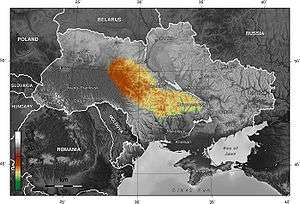
The Dnieper Upland or Cisdnieper Upland (Ukrainian: Придніпровська височина) is a southeastern European plain occupying the territory between the Dnieper and Bug rivers. It lies in central Ukraine, occupying the oblasts of Zhytomyr, Kiev, Vinnitsa, Cherkasy, Kirovohrad and Dnipropetrovsk.
To its north lies Polesian Lowland, to the south lies Black Sea Lowland, eastern border is served by Dnieper. To the west of Dnieper Upland lies uplands of Podillya and Volhynia (see Volhynian-Podolian Upland).
Among prominent features of the upland are Kiev Mountains, Hills of Kaniv, others.
The upland contains a number of minerals including iron, manganese, granite, graphite, brown coal, kaolin etc.[1]
References
External links
- Dnieper Upland at the Encyclopedia Britannica
- Dnieper Upland at the Great Soviet Encyclopedia
- Dnieper Upland at the Ukrainian Soviet Encyclopedia
- Zastavny, F.D. Physical geography of Ukraine.
Coordinates: 49°07′00″N 30°37′00″E / 49.1167°N 30.6167°E