Donalsonville Municipal Airport
| Donalsonville Municipal Airport Donalsonville Army Auxiliary Airfield | |||||||||||
|---|---|---|---|---|---|---|---|---|---|---|---|
|
2006 USGS airphoto | |||||||||||
| IATA: none – ICAO: none – FAA LID: 17J | |||||||||||
| Summary | |||||||||||
| Serves | Donalsonville, Georgia | ||||||||||
| Coordinates | 31°00′29″N 084°52′23″W / 31.00806°N 84.87306°W | ||||||||||
| Map | |||||||||||
 17J Location of Donalsonville Municipal Airport | |||||||||||
| Runways | |||||||||||
| |||||||||||
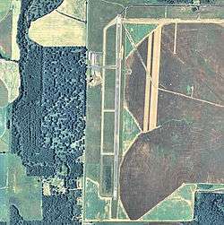
Donalsonville Municipal Airport is an airport located 2 miles south of Donalsonville, Georgia.
History
Opened in July 1944, during World War II, the airport was used as an auxiliary training airfield for the Army pilot school at Bainbridge Army Airfield. With the end of the war, it was turned over to the city of Donalsonville and developed into a municipal airport.
See also
References
![]() This article incorporates public domain material from the Air Force Historical Research Agency website http://www.afhra.af.mil/.
This article incorporates public domain material from the Air Force Historical Research Agency website http://www.afhra.af.mil/.
External links
- FAA Terminal Procedures for 17J, effective November 10, 2016
- Resources for this airport:
- FAA airport information for 17J
- AirNav airport information for 17J
- FlightAware airport information and live flight tracker
- SkyVector aeronautical chart for 17J
| Flying Training |
|  | ||||||
|---|---|---|---|---|---|---|---|---|
| Technical Training |
| |||||||
This article is issued from Wikipedia - version of the 5/22/2016. The text is available under the Creative Commons Attribution/Share Alike but additional terms may apply for the media files.