Donard Forest
| Donard Forest | |
|---|---|
|
A path within Donard Forest | |
| Geography | |
 Location of Donard Forest | |
| Location | Down, Northern Ireland, United Kingdom |
| Coordinates | 54°12′11″N 5°54′07″W / 54.203°N 5.902°WCoordinates: 54°12′11″N 5°54′07″W / 54.203°N 5.902°W |
| Area | 296.82 hectares (733.5 acres) |
| Governing body | Forest Service Northern Ireland |
_-_geograph.org.uk_-_467058.jpg)
Donard Forest is located near Newcastle, County Down, Northern Ireland. It borders Donard Park at the foot of the Mourne Mountains. The Glen River flows through the forest where it is crossed by three stone bridges. The north east section of the forest contains a Heritage Stand of Scots and Corsican pine planted in 1927.[1] A south east section, beside the Glen River, was the former site if Donard Lodge. The lodge was built in the 1830s by the Annesley family and demolished in 1966 after falling into ruin.[2] The Annesleys planted a number of exotic trees in the area surrounding the house, including Giant Redwoods and Monkey Puzzles.[1] There is also a small stone shelter, built in 1842, a short distance from the river.
-
_-_geograph.org.uk_-_640714.jpg)
Stone Shelter within Donard Forest
-
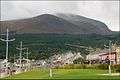
Donard Forest as seen from Newcastle Promenade
References
- 1 2 "Donard Forest". NI Direct. Retrieved 17 December 2014.
- ↑ Carson, Charles J. T. (2009). Technology and the Big House in Ireland, C. 1800-c. 1930. Cambria Press. pp. 123–124. ISBN 9781604976359.