Douthitt Strip
| Douthitt Strip | |||||||||||||||
|---|---|---|---|---|---|---|---|---|---|---|---|---|---|---|---|
|
USGS 2002 orthophoto | |||||||||||||||
| IATA: none – ICAO: none – FAA LID: 23CN | |||||||||||||||
| Summary | |||||||||||||||
| Airport type | Private use | ||||||||||||||
| Owner | R. Douthitt Enterprises, Inc. | ||||||||||||||
| Serves | El Centro, California | ||||||||||||||
| Elevation AMSL | 45 ft / 14 m | ||||||||||||||
| Coordinates | 32°47′20″N 115°31′47″W / 32.78889°N 115.52972°WCoordinates: 32°47′20″N 115°31′47″W / 32.78889°N 115.52972°W | ||||||||||||||
| Map | |||||||||||||||
 23CN Location of airport in California | |||||||||||||||
| Runways | |||||||||||||||
| |||||||||||||||
| Statistics | |||||||||||||||
| |||||||||||||||
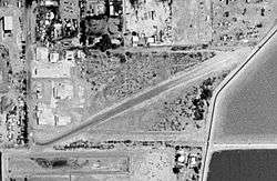
Douthitt Strip (FAA LID: 23CN) is a privately owned, private use airport located one nautical mile (2 km) east of the central business district of El Centro, a city in Imperial County, California, United States.[1]
History
Provided contract glider training to the United States Army Air Forces, 1942-1944. Training provided by Aeronautical Training Center, Inc. Used primarily C-47 Skytrains and Waco CG-4 unpowered Gliders. The mission of the school was to train glider pilot students in proficiency in operation of gliders in various types of towed and soaring flight, both day and night, and in servicing of gliders in the field.
Facilities and aircraft
Douthitt Strip has two runways with dirt surfaces: 4/22 is 1,800 by 100 feet (549 x 30 m) and 8/26 is 1,400 by 100 feet (427 x 30 m). There are 23 aircraft based at this airport: 91% single-engine and 9% ultralight.[1]
See also
-
 Military of the United States portal
 -
 United States Air Force portal
 - California World War II Army Airfields
References
Other sources
-
 This article incorporates public domain material from the Air Force Historical Research Agency website http://www.afhra.af.mil/.
 - Shaw, Frederick J. (2004), Locating Air Force Base Sites History’s Legacy, Air Force History and Museums Program, United States Air Force, Washington DC, 2004.
- Manning, Thomas A. (2005), History of Air Education and Training Command, 1942–2002. Office of History and Research, Headquarters, AETC, Randolph AFB, Texas ASIN: B000NYX3PC
External links
- Aerial image as of May 2002 from USGS The National Map
- Resources for this airport:
- FAA airport information for 23CN
- AirNav airport information for 23CN
- FlightAware airport information and live flight tracker
- SkyVector aeronautical chart for 23CN
| Flying Training |
|  | ||||||
|---|---|---|---|---|---|---|---|---|
| Technical Training |
| |||||||