Downtown Albuquerque
| Downtown | |
|---|---|
| Neighborhood of Albuquerque | |
|
Downtown Albuquerque | |
| Coordinates: 35°05′02″N 106°39′00″W / 35.084°N 106.65°WCoordinates: 35°05′02″N 106°39′00″W / 35.084°N 106.65°W | |
| Government[1] | |
| • City Council | Debbie O'Malley |
| • State House | Rick Miera (D) |
| • State Senate | Jerry Ortiz y Pino (D) |
| • U.S. House | Michelle Lujan Grisham (D) |
| Area | |
| • Total | 0.40 sq mi (1.0 km2) |
| Population (2010)[2] | |
| • Total | 1,237 |
| • Density | 3,092.5/sq mi (1,194.0/km2) |
| ZIP Code | 87102[1] |
| Area code(s) | 505 |

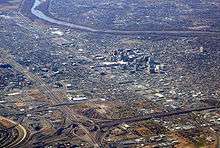
Downtown Albuquerque is the central business district of Albuquerque, New Mexico. It is where a large number of the city's highrise buildings are located, as well as being the center of government and business for the region.
Downtown is roughly defined as the area between Marble Avenue, Coal Avenue, Sixth Street, and the Burlington Northern Santa Fe railroad tracks. The area on the east side of the railroad tracks is known as East Downtown or EDo.
Street grid
Downtown Albuquerque is laid out in a standard grid pattern, with numbered north-south streets and named east-west avenues. Central Avenue (originally known as Railroad Avenue) is the main east-west thoroughfare through the center of Downtown, while Lomas Boulevard (originally New York Avenue) is a major east-west arterial through the north part of downtown.
The streets start with First Street just west of the railroad tracks and increase in number moving westward. Fourth Street was originally the main north-south thoroughfare through Downtown but today it is discontinuous, interrupted by Civic Plaza and a two-block pedestrian mall north of Central. Since these developments took place Second Street has been the main north-south street through downtown.
Fourth Street through downtown Albuquerque was part of U.S. Route 66 prior to the route's 1937 realignment. Afterwards, Route 66 ran along Central Avenue until its decommissioning.
Districts
Downtown Albuquerque is divided into six official districts, which are identified by a unified system of signage and icons.
Courthouse District
Located on the north side of downtown, this district is bounded by Marble Avenue, Roma Avenue, Second Street, and Seventh Street. It is named for the three major courthouses located at the intersection of Fourth and Lomas: Pete V. Domenici United States Courthouse, Bernalillo County Courthouse, and the Bernalillo County Metropolitan Courthouse.
Warehouse District
On the north side of downtown along the railroad tracks, the Warehouse District includes the area between Second and the railroad tracks, north of the Convention Center to Slate Avenue. As its name implies, this area contains mostly warehouses from the railroad era.
Plaza District
The Plaza District is the central area of downtown, bounded by Roma, Copper, Seventh, and the railroad tracks. It is centered on Civic Plaza and includes many of Albuquerque's large office and government buildings including the Albuquerque City-County Building, the Convention Center, Albuquerque Plaza, the Compass Bank Building, and the Albuquerque Petroleum Building. The Main Library of the Albuquerque/Bernalillo County Library System is also located in this district.
Arts and Entertainment District
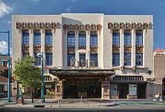
This district is centered along Central Avenue and Gold Avenue east of First Street. It contains most of downtown Albuquerque's historic buildings as well as most of its shopping, dining, and nightlife destinations. Notable landmarks in this district include the KiMo Theater, Occidental Life Building, First National Bank Building, and Sunshine Building. There is a small concentration of government and office buildings on Gold Avenue which includes the Dennis Chavez Federal Building, Gold Building, and Simms Building. Amy Biehl High School is also located in this district.
Transportation Center District
This is the smallest district, encompassing the area south of Central Avenue and east of First Street. Most of the district is occupied by Alvarado Transportation Center.
Casa District
The southernmost part of downtown, the Casa District includes the area between Gold and Coal Avenue, extending all the way west to Tenth Street. This is a primarily residential district, with a large number of loft apartment buildings. The PNM Building is also located in the Casa District.
EDo
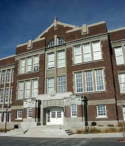
Not one of the official downtown districts, EDo (East Downtown) is a small but expanding neighborhood centered on Central and Broadway on the east side of the railroad tracks, bounded roughly by the railroad tracks on the west, I-25 on the east, Coal on the south, and Martin Luther King Avenue on the north. EDo is a trendy area containing several loft apartment buildings and a number of small shops and restaurants. The focal point of EDo is the renovated Old Albuquerque High School campus, which is now a residential complex. The name "EDo" was coined in imitation of the LoDo area of Denver which in turn was an imitation of SoHo and TriBeCa in New York City .
Buildings
Tallest buildings
Downtown Albuquerque contains most of the city's highrise buildings, including the four tallest. The tallest downtown buildings are listed below:
| Rank | Name | Height | Floors |
|---|---|---|---|
| 1 | Albuquerque Plaza | 351 feet (107 m) | 22 |
| 2 | Hyatt Regency Albuquerque | 256 feet (78 m) | 21 |
| 3 | Compass Bank Building | 238 feet (73 m) | 18 |
| 4 | Albuquerque Petroleum Building | 235 feet (72 m) | 15 |
| 5 | Gold Building | 203 feet (62 m) | 14 |
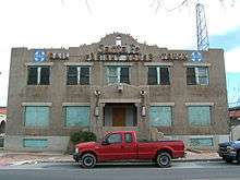
Historic landmarks
There are a number of buildings in downtown that are on the National Register of Historic Places:
- KiMo Theater, one of the city's best-known landmarks
- The old Federal Building and U.S. Courthouse
- First National Bank Building
- Hotel Andaluz
- Occidental Life Building
- Old Post Office
- Simms Building
- Southwestern Brewery and Ice Company
- Sunshine Building
Transportation
Downtown is the center of public transit in the city, and is served by a network of ABQ RIDE routes including both Rapid Ride BRT routes, most of which include stops at the Alvarado Transportation Center. ABQ RIDE also operates a free circulator bus service in the downtown area named Downtown Get Around (or "D-Ride" for short) which runs from 6:30 am to 7:00 pm every 7 minutes on weekdays.
In addition to local bus transit, the Alvarado Transportation Center also incorporates Amtrak and Greyhound bus facilities, as well as a stop on the New Mexico Rail Runner Express commuter rail line. The rail runner express provides commuter service seven days a week along a 96.5-mile corridor that runs through multiple counties in New Mexico through 13 stations.
References
- 1 2 "Albuquerque GIS Data". City of Albuquerque. Retrieved 12 March 2012.
- ↑ "2010 Census Summary File 1, Table P1". U.S. Census Bureau. Retrieved 22 April 2012.