Downtown Spokane
| Downtown Spokane Riverside | |
|---|---|
| Neighborhood of Spokane | |
|
Downtown from the West | |
| Coordinates: 47°39′27″N 117°25′14″W / 47.65750°N 117.42056°WCoordinates: 47°39′27″N 117°25′14″W / 47.65750°N 117.42056°W | |
| Country | United States |
| State | Washington |
| County | Spokane County |
| City | Spokane |
| Area | |
| • Total | 0.99 sq mi (2.6 km2) |
| ZIP Code | 99201, 99202 |

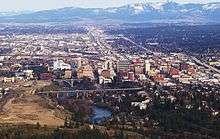
Downtown Spokane, officially the Riverside neighborhood, is the central business district in Spokane, Washington. Downtown Spokane's rough boundaries are I-90 to the south, Division Street to the east, Maple Street to the west, and across the Spokane River north to Boone Avenue. Bridges (some of them pedestrian-only) span the river at nearly every block.
Buildings
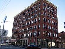
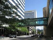
The Bank of America Financial Center, standing at 288 feet (88 m) tall, is the tallest building in Spokane. It was completed in 1981. The nearby Wells Fargo Center is the second tallest building (243 ft), and was completed in one year later 1982. Until 2006, with the construction of the Davenport Tower & Residences (an expansion of The Davenport Hotel), no other high-rise has gone up in Spokane.
Other significant buildings in downtown include the Spokane Convention Center, the INB Performing Arts Center, and the Spokane Arena.
Geography
The topography of Downtown Spokane is mostly flat except for areas downstream of the Spokane Falls which are located in a canyon. South of downtown slopes up to the South Hill, quite steeply in some places such as Pioneer Park, where long cliffs oriented east-west provide great views of the downtown, the North Side and Spokane Valley to the east.
Downtown straddles Sprague Avenue, which divides the city into North and South. On the eastern end of Downtown, Division Street splits the city into East and West. I-90 is elevated through almost all of downtown, often with parking lots underneath, but occasional blocks are solid cement, forming a barrier at the southern end of Downtown. Immediately south of the Interstate the high density area continues into a growing medical district with Spokane's two largest hospitals, Sacred Heart and Deaconess.
To the west is one of Spokane's oldest and densest neighborhoods, Browne's Addition. In the photo, Browne's addition is the treed area in the foreground on the right. The left side of the foreground is the valley cut by the Spokane river immediately downstream of the falls; this is the small and similar neighborhood of Peaceful Valley.
Gonzaga University is located just upstream on the north side of the river from Downtown. Across the river from Gonzaga are the new University District home campuses of Eastern Washington University and Washington State University. Division Street separates Downtown from the University District.
Downtown rebirth and development

Downtown Spokane had undergone a major rebirth in the years before the recession, after the completion of the River Park Square Mall.[1] The historic Davenport Hotel underwent a major renovation in 2002 after being vacant for over 20 years.[2] The project was funded by local entrepreneur Walt Worthy, who also added a Safari-themed 20 story tower to the hotel in 2007. Other major projects include the Holley Mason Building - seen as the catalyst to downtown Spokane's rebirth, the building of the Big Easy concert house (now renamed the Knitting Factory), the remodeling of the historic Montvale Hotel and Fox Theater (now home to the Spokane Symphony), numerous new condo buildings, and renovations of historic, older brick buildings that will soon house both condos and business. Also, the Spokane Convention Center just finished a major expansion which helped host the 2007 US Figure Skating Championships.[3]
Districts and areas
Riverfront Park

Riverfront Park, created after Expo '74 and occupying the same site, is 100 acres (0.40 km2) in downtown Spokane and the site of some of Spokane's largest events.[4] The park has views of the Spokane Falls, and holds a number of civic attractions, including a Skyride that is a rebuilt gondola that carries visitors across the falls from high above the river gorge, a 5-story IMAX theater, and a small amusement park (which is converted into an ice-skating rink during the winter months) with numerous rides and concessions.[4] The park is host to a full schedule of family entertainment and events such as the Bloomsday Post-Race Celebration, Hoopfest, the IMAX Film Festival, Spokane Music Festival, Pig-Out in the Park, Restaurant Fair, Pow Wow, First Night Spokane, plus many outdoor concerts and other community activities. The Park also includes a hand-carved carousel created in 1909 by Charles I. D. Looff as a wedding present for his daughter.[5] The carousel still operates in Riverfront Park, where riders can participate in an old-time ring toss. The carousel continues to offer a free ride to the rider who grabs the brass ring. Riverfront Park also includes ample views of the Spokane falls as well as other water features (some man-made) of the Spokane River.
Downtown Core
The Downtown Core is the heart of Downtown Spokane and is generally considered to be the several block vicinity surrounding Spokane City Hall, River Park Square, the STA Plaza, and the Davenport Hotel. A majority of Spokane's high-rise buildings are located in this core area. Spokane's skywalk system also overlays the street grid and street life within the core, linking 14 blocks together. A number of downtown's retailers and restaurants are also located within the Downtown Core.
Arts and Entertainment District
The entertainment district is located just south of the Downtown Core and is home to a number of restaurants, boutique hotels, performing arts and concert venues (including the Fox Theater).
Convention Center District

The Convention Center District is situated to the east of the Downtown Core and is anchored by the Spokane Convention Center and INB Performing Arts Center. Its location is directly adjacent to Riverfront Park; an advantage that has been embraced through careful planning and architectural design of buildings in the district which allows the buildings to interface with the park, the river, and recreational trails (including the Centennial Trail) that run along it. The district was born out of Expo '74, which developed the original structure that ultimately became the INB Performing Arts Center and the Spokane Convention Center. The convention center has been expanded several times since its original construction, stretching the bounds of the district farther east, where it ties into the University District.
Much of the other development around the Convention Center District stems from the Spokane Convention Center and the INB Performing Arts Center, including restaurants, retail, and hotels. Spokane's largest and tallest hotels, including the DoubleTree, Davenport Grand, and Red Lion Hotel at the Park are located in or immediately adjacent to the convention center district. The business types located around the Convention Center District provide a common overlap with businesses supporting the adjacent University District as well, helping to alleviate some of the "urban dead zones" that are all too commonly created when the convention centers - particularly large ones in major cities much larger than Spokane - are not in use.
Kendall Yards
Located along the southern edge of the West Central neighborhood just across the Spokane River from Downtown Spokane is Kendall Yards, a new urbanist community. Though not officially within the boundaries of Downtown Spokane, Kendall Yards plays a vital role in the culture and future of downtown by increasing the urban residential population in the immediate vicinity of it.
The neighborhood is one of the largest urban infill development projects in the city's history and has reclaimed a brownfield formerly occupied by rail yards. The site of Kendall Yards used to be the main entry point of the railroad into Downtown Spokane before alterations to the downtown area in preparations for Expo '74 relocated the railroads south of the Spokane River. The 78-acre (0.32 km2) site sat vacant from that point on for another three decades until 2005, when a brownfield cleanup [6] took place in preparations for the groundbreaking of the development. The cleanup, which won an US EPA award, took approximately one year and removed over 223,000 tons of contaminated soil from the site.[7]
The initial proposal for Kendall Yards called for 2,600 residences and 1 million square feet of commercial space, worth up to $1 billion. The development broke ground in 2007, however, the impending Great Recession bankrupted the project's developer before any buildings were constructed. The now cleaned-up site continued to sit vacant for another few years until a Spokane-based developer, Greenstone Corp., purchased the site in 2009 and began construction in 2010.[8] In response to the economic conditions at the time, the original plans for the development were scaled back; the proposed density, residential unit count, and commercial square footage were all reduced to approximately one-half of the original scope. However, the scaled-back plans did have its advantages; the development was more likely to be successful, the more land would be available for open green space, and the reduced density would be more compatible with the existing fabric of the adjacent West Central neighborhood to the north. Construction of the development is phased and is expected to be ongoing through the mid-2020s.

Designed on new urbanist principles, the plan and makeup of the neighborhood emphasizes mixed-use development, diversity of densities and housing types, open space, and walkability. Much of the neighborhood consists of multi-family structures of townhomes, condominiums, and apartments. There are also single-family detached homes, community gardens, free-standing commercial buildings, and mixed-use buildings (with ground-floor retail and apartment units above). Green and recreational space is also emphasized; the community includes parks, sidewalks, and plazas and also completed a long-awaited infill section of the Centennial Trail, extending it from Downtown through the entire 78-acre (0.32 km2) site along the northern banks of the Spokane River Gorge.
North Bank
The North Bank area is located to the north of the Spokane River and Riverfront Park. It is home to a variety of uses including civic, residential, shopping, dining, and lodging. Destinations include the Spokane Arena, the central YMCA/YWCA, Spokane Civic Theater, and Flour Mill. A number of businesses based on the North Bank are in the health, banking, hotel, and real estate industries.
Cityscape

Surrounding Areas
- Browne's Addition
- South Hill
- University District
See also
- Spokane, Washington
- Neighborhoods in Spokane, Washington
- National Register of Historic Places listings in Spokane County, Washington
- List of tallest buildings in Spokane
References
- ↑ "Welcome to Downtown Spokane". Downtown Spokane Partnership. Retrieved 2008-12-14.
- ↑ "Hotel History". The Davenport Hotel and Tower. Retrieved 2009-01-25.
- ↑ "About The Spokane Convention Center". Spokane Convention Center. Retrieved 2009-01-15.
- 1 2 "About the Park". Riverfront Park. Retrieved 2009-01-25.
- ↑ "Natatorium Carousel/ Looff Carousel". City-County of Spokane Historic Preservation Office. Archived from the original on June 10, 2008. Retrieved 2009-01-25.
- ↑ Spokane does brownfields on a grand scale
- ↑ Railroad cleanup gets EPA award
- ↑ Work begins on Kendall Yards housing