Dunn Loring station
 | |||||||||||
| Location |
2700 Gallows Road Vienna, VA 22180 | ||||||||||
| Owned by | Washington Metropolitan Area Transit Authority | ||||||||||
| Line(s) |
| ||||||||||
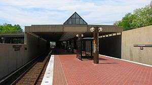
| Platforms | 1 island platform | ||||||||||
| Tracks | 2 | ||||||||||
| Bus stands | 7 | ||||||||||
| Bus operators |
| ||||||||||
| Construction | |||||||||||
| Structure type | Surface | ||||||||||
| Parking | 2,000 spaces | ||||||||||
| Bicycle facilities | 40 racks, 34 lockers | ||||||||||
| Disabled access | Yes | ||||||||||
| Other information | |||||||||||
| Station code | K07 | ||||||||||
| History | |||||||||||
| Opened | June 7, 1986 | ||||||||||
| Previous names |
Dunn Loring (1986–1998) Dunn Loring–Merrifield (1998–2011) | ||||||||||
| Traffic | |||||||||||
| Passengers (2015) |
4386 daily [1] | ||||||||||
| Services | |||||||||||
| |||||||||||
Dunn Loring is a Washington Metro station in Fairfax County, Virginia on the Orange Line. The station is located in Merrifield, with a Vienna postal address. The station is located in the median of Interstate 66 at Gallows Road, just outside the Capital Beltway, and is accessed via a footbridge over the eastbound lanes.
The station opened on June 7, 1986.[2] Its opening coincided with the completion of 9.1 miles (14.6 km) of rail west of the Ballston station and the opening of the East Falls Church, West Falls Church and Vienna stations.[2] By 1993, officials in Fairfax City were looking to add "Merrifield" to the station name.[3] In 1998, the station name was changed to "Dunn Loring-Merrifield".[4] On November 3, 2011, the station was returned to its original name, with "Merrifield" listed as a subtitle.[5]
Station layout
| P Platform level |
Westbound | ← |
| Island platform, doors will open on the left | ||
| Eastbound | → | |
| M | Mezzanine | One-way faregates, ticket machines, station agent |
| G | Street Level | Exit/ Entrance |
Development project
In August 2011, Mill Creek Residential Trust began development on a new mixed-use development area in cooperation with WMATA known as Alexan Dunn Loring.[6] The project is required to not reduce the number of parking spaces.[7] The first step completed was to remove the existing kiss and ride area, as well as the bus bays. This area became the primary metro parking lot, while the old parking lot was built into a new parking garage. The new parking garage opened August 2013.[8] After the parking garage opened, construction began on the mixed-use development in the area of the temporary parking lot. Phase 1 of the mixed-use development project is scheduled to be completed first quarter 2014.[9][10] Construction is expected to complete in 2015.[6]
References
- ↑ "Metrorail Average Weekday Passenger Boardings" (PDF). WMATA. Retrieved 2016-06-07.
- 1 2 Lynton, Stephen J. (June 8, 1986), "9.1 more miles for Metrorail", The Washington Post, p. C1
- ↑ Shear, Michael D. (August 26, 1993), "Angling to get on Metro Map; Merrifield, Fairfax City want stations renamed", The Washington Post, p. V1
- ↑ Pae, Peter (August 21, 1997), "New names for Metro stations", The Washington Post, p. V1
- ↑ "Station names updated for new map" (Press release). Washington Metropolitan Area Transit Authority. November 3, 2011. Archived from the original on November 5, 2011. Retrieved November 5, 2011.
- 1 2 "Dunn Loring-Merrifield Metrorail Station". wmata.com. Washington Metropolitan Area Transit Authority. Retrieved 2014-11-10.
- ↑ "Environmental Document" (PDF). wmata.com. Washington Metropolitan Area Transit Authority. 2009. Retrieved 2014-11-10.
Through out any phase of construction of the proposed development, at least 1,355 parking spaces (existing number of spaces today) must be available to Metro patrons.
- ↑ Hedgpeth, Dana (August 20, 2013). "New Metro parking garage at Dunn Loring". The Washington Post. Retrieved 2014-11-10.
- ↑ "Dunn Loring-Merrifield Metro" (PDF). JBGR Retail. Retrieved 2014-11-10.
Delivery Date: 1st Quarter 2014
- ↑ "Dunn Loring Metro Apartments". Mill Creek Residential Trust. Retrieved 2014-11-10.
Leasing to begin May 2013
External links
![]() Media related to Dunn Loring (WMATA station) at Wikimedia Commons
Media related to Dunn Loring (WMATA station) at Wikimedia Commons
- WMATA: Dunn Loring Station
- WMATA: Washington Metro Map, showing orange line
- StationMasters Online: Dunn Loring Station
- The Schumin Web Transit Center: Dunn Loring Station
- Gallows Road entrance from Google Maps Street View
Coordinates: 38°53′00″N 77°13′42″W / 38.883304°N 77.228388°W