Dutch Gap

Dutch Gap is located on the James River in Chesterfield County, Virginia; it was started as a canal by Union forces during the American Civil War to cut off a curl of the river controlled by Confederate forts. The canal was completed after the war and is now the main channel of the James River in this area. It is south of the lost 17th-century town of Henricus.[1] The Henricus Historical Park is devoted to that town.
History
In 1611, Sir Thomas Dale, according to a method he had learned while campaigning in Holland, cut a ditch across a portion of land behind town connecting two parts of the James River. It became known as "Dale's Dutch Gap". It was a way to protect the rear of the town from possible attack and shorten the distance upriver. This length of the James River had broad, meandering stretches between Drewry's Bluff, where the river turns east into the coastal plain, and the confluence of the Appomattox River with the James below Bermuda Hundred.
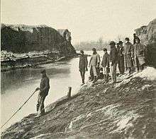
During the American Civil War, Union troops started to construct a larger canal at Dutch Gap late in 1864. Among their workers were paid African-American laborers from the Freedmen's Colony of Roanoke Island. They had been freed by Union forces and were pressed into service away from their base off the mainland of North Carolina.[2]
By that time, some freedmen were serving as soldiers in the United States Colored Troops. They took part in the military action at Dutch Gap. The Union Army intended to cut off the large curl of the James threatened by Confederate forts, such as Battery Dantzler where Confederate forces had installed two seven inch Brooke rifles, two ten-inch Columbiad guns, and two siege mortars overlooking Trent's Reach to prevent the U.S. navy vessels from approaching the Confederate capital at Richmond.
The Union could not complete expansion of the canal during the war, but it was completed later. It has become the main channel of the James River in that area. An electricity-generating facility of Dominion Virginia Power Company is located nearby on the south shore of the James River.
The Dutch Gap Conservation Area includes the archaeological site of Henricus. The Henricus Historical Park is located north of Dutch Gap in Chesterfield County (it was subdivided from Henrico County in 1749).
References
Coordinates: 37°22′37″N 77°21′21″W / 37.3770°N 77.3558°W David F. Bastian, Union Soldiers Dredge Canal at Dutch Gap to Avoid Rebel Fleet, World Dredging, pp. 22-25, October 1977