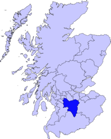
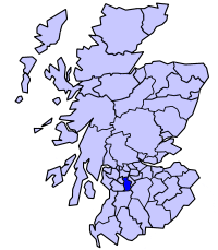
East Kilbride
| East Kilbride, South Lanarkshire | |
| Scottish Gaelic: Cille Bhrìghde an Ear | |
| Scots: East Kirkbride | |
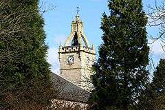 Kilbride parish church tower |
|
 East Kilbride, South Lanarkshire |
|
| Population | 74,411 [1] |
|---|---|
| OS grid reference | NS635545 |
| Civil parish | East Kilbride[2] |
| Council area | South Lanarkshire |
| Lieutenancy area | Lanarkshire |
| Country | Scotland |
| Sovereign state | United Kingdom |
| Post town | GLASGOW[3] |
| Postcode district | G74-75 |
| Dialling code | 01355 & 0141 |
| Police | Scottish |
| Fire | Scottish |
| Ambulance | Scottish |
| EU Parliament | Scotland |
| UK Parliament | East Kilbride, Strathaven and Lesmahagow |
| Scottish Parliament | East Kilbride |
Coordinates: 55°45′52″N 4°10′38″W / 55.764529°N 4.17711°W
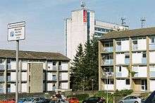
East Kilbride (Scottish Gaelic: Cille Bhrìghde an Ear) is the largest town in South Lanarkshire in Scotland. It is also designated as Scotland's first new town on 6 May 1947. The area lies on high ground on the south side of the Cathkin Braes, about 8 miles (13 km) southeast of Glasgow and close to the boundary with East Renfrewshire.
The town is enclosed by the White Cart River to the west and the Rotten Calder to the east, the latter flowing northwards to join the River Clyde near Cambuslang. This area was previously the site of the small village of East Kilbride, prior to its post-war development.
History

The earliest evidence of habitation in the area dates back to ancient graves found near the Kype Water to the south of the district. Roman coins and footwear have also been found in the area.
East Kilbride takes its name from an Irish saint named St Bride (or Brigit), who founded a monastery for nuns and monks in Kildare, Ireland in the 6th century. Dál Riatan monks introduced her order to Scotland. The anglicisation Kil, takes its root from the early Celtic monastics that St. Brigit is representative of: the Culdees or Céli Dé. The Céile Dé were 'the clients or companions of God'. In modern Gaelic, Cille Bhrìghde translates similarly as 'the clients or companions of Brigit.
The original parish church was located on the site of a pre-Christian sacred well, which is possibly the origin of the association with St. Brigit, since the well was dedicated to the Celtic goddess Brigid, whose traditions have been continued through the reverence of St. Brigit. Over the centuries, the church has been destroyed and rebuilt several times, and, as a result, its current location has moved from the original site by about 50 metres (160 ft).
The area of Calderglen was celebrated as a picturesque wooded valley. It was the home of a noble family known as the 'Maxwells of Calderwood' who resided in Calderwood Castle. The remnants of Calderwood Castle were demolished in 1951 and only a few parts of the structure remain.
East Kilbride grew from a small village of around 900 inhabitants in 1930 to eventually become a large burgh. The rapid industrialisation of the twentieth century underpins this growth and left much of the working population throughout Scotland's Central Belt, from Glasgow to Edinburgh, living in the housing stock built at the end of the previous century. The Great War postponed any housing improvements, as did the Treaty of Versailles and the period of post-war settlement it created. In turn, this was followed by the Great Depression. After the Second World War, Glasgow, already suffering from chronic housing shortages, incurred bomb damage from the war.
From this unlikely backdrop a new dawn emerged which would bring East Kilbride to its unlikely success. In 1946, the Clyde Valley Regional Plan allocated sites where overspill satellite "new towns" could be constructed to help alleviate the housing shortage.[4] Glasgow would also undertake the development of its peripheral housing estates. East Kilbride was the first of five new towns in Scotland to be designated, in 1947, followed by Glenrothes (1948), Cumbernauld (1956), Livingston (1962) and Irvine (1964).[5]
The town has been subdivided into residential precincts, each with its own local shops, primary schools and community facilities. The housing precincts surround the shopping centre, which is bound by a ring road. Industrial estates are concentrated on the outskirts of the town, in northern, western and southern directions.
Geography
East Kilbride forms part of the Greater Glasgow conurbation. However, the urban area is not directly connected to any other. The hamlets of Nerston and Jackton which were once separate settlements are now on the periphery of the expanding town.
The nearest Glasgow district of Castlemilk is about 3 miles to the north-west, with the village of Carmunnock in between (a bypass has been built in recent years to remove Glasgow traffic from Carmunnock). Rutherglen and Cambuslang lie about the same distance to the north-east and are linked to East Kilbride via the Dual carriageway A749 road which continues into Glasgow.
Clarkston and Busby are also about 3 miles away to the west, with Thorntonhall much closer. Eaglesham lies to the south-west (again this is about 3 miles from East Kilbride centre). Another modern bypass keeps East Kilbride traffic heading for the M77 motorway away from Eaglesham.
The closest town to the south of East Kilbride is Strathaven, about 7 miles away. The majority of land in that area is taken up by Whitelee Wind Farm.
Hamilton, the admistrative headquarters of South Lanarkshire is about 5 miles from East Kilbride to the east. The road linking the towns also leads to Blantyre and Bothwell and ultimately to the M74 motorway.
Governance
From 1975 East Kilbride lent its name to a local government district in the Strathclyde region. In 1996 administrative functions were taken over by the South Lanarkshire unitary council.
There is an East Kilbride constituency of the Scottish Parliament. From the opening of the Scottish Parliament, the constituency was represented by Andy Kerr MSP (Labour), until May 2011 when the seat was won by Linda Fabiani MSP (Scottish National Party).
East Kilbride was formerly a constituency of the UK Parliament. In 2005 it was replaced by the constituency of East Kilbride, Strathaven and Lesmahagow. The seat was held from 1987 to 2010 by Labour politician, Adam Ingram. In the 2010 election Labour politician, Michael McCann, previously a South Lanarkshire Councillor was elected as the MP for the area. In the 2015 election, Lisa Cameron for the SNP was elected as part of the landslide victory the party had in Scotland.
Culture
East Kilbride hosted the National Mòd in 1975.[6]
Economy
The town centre is occupied by a large shopping centre comprising 6 linked malls, developed in phases. The malls are known by local residents as "The Centre".
The six malls are The Plaza (development started in 1972), Princes Mall (1984), Olympia (1988), Southgate (1989), Princes Square (1997) and Centre West (2003). The shopping centre has come under recent criticism for losing major retail chains in light of rising rental prices. This coupled with the Centre West expansion and decreasing shopper numbers has allowed swathes of properties within the centre to remain closed for months at a time, notably on the first floor of Centre West and the Plaza.
A£400m redevelopment of East Kilbride shopping centre was approved in 2006 by South Lanarkshire Council. The plan proposed demolishing some existing buildings to create a new civic centre, health centre, library and shopping facilities.[7][8] It would also see a "landmark" arts and culture complex with a 1,000-seat theatre, a 500-seat conference centre, a museum and a new town square. However, the project has been indefinitely delayed.
A branch of the government's Department for International Development is located on the western edge of East Kilbride at Hairmyres.[9]
Local areas
East Kilbride is divided into a number of smaller areas bordered by main through-roads. Part of the new town design was that each of these would be a self-contained entity, with local shops and primary schools. This is true for the original areas of the town but newer developments, such as Stewartfield do not adhere to this model.
Religion
There are approximately 30 Christian churches in East Kilbride. This includes nine Church of Scotland churches, three Baptist churches, and four Roman Catholic churches. St. Mark's Episcopal church is situated in the Murray. There is one Lutheran parish of the Evangelical Lutheran Church of England, which is located in the Westwoodhill area. An Evangelical Christian congregtion is also located in the Westwood area.[10] The Church of Jesus Christ of Latter Day Saints meeting hall is situated in Vancouver Drive, Westwood. Three congregations of Jehovah's Witnesses share a Kingdom Hall near the centre of the town. The Christadelphians meet in Calderwood Community Centre.[11] There are two United Reformed Churches, one in the Village,[12] and one in the Murray.[13] In the Green hills area is a congregation of the Methodist church, whose premises are currently shared by the Seventh Day Adventists church.
Transport
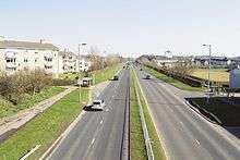
East Kilbride is connected to Glasgow city centre by road and rail. Three main roads connect East Kilbride with surrounding suburbs and the city, one being the A727 (formerly A726) leading west to Busby and on to Clarkston Toll. Another route being the A749 which runs north into Rutherglen. Recently, the addition of the Glasgow Southern Orbital road links the west of the town directly with Newton Mearns and the M77. This road has taken over the designation A726. Similar to other New Towns, the road network within the area is populated by many roundabouts;[14] Glaswegians jokingly refer to East Kilbride as "Polo mint City" after the round, mint sweet.[15] The main dual carriageway road running north-south through the town is known as the Kingsway, while the main east-west road is known as the Queensway.
Public transport
East Kilbride bus station, at the East Kilbride Shopping Centre, was rebuilt in June 2005 with modern facilities, including 14 rapid drive-through stances, allowing quick turnover of buses. East Kilbride railway station is situated in the Village, about a 10-minute walk from the bus station. Trains depart to Glasgow Central railway station every half-hour, with a journey time of about 27 minutes. The town is also served by Hairmyres railway station in Hairmyres.
East Kilbride's primary bus operator is First Glasgow which provides regular services to the city centre, Busby, Clarkston, Castlemilk, Rutherglen, Blantyre, Hamilton, Motherwell and to many other destinations across Greater Glasgow. Stagecoach West Scotland provide a half-hourly to hourly service to Ayr. Arriva Scotland West ran an hourly 600 service to the Airport via: Busby, Clarkston, Giffnock, Thornliebank, Silverburn Centre, Hurlet, and Paisley, but this was discontinued in late 2009. McGill's Bus Services and local company, Whitelaws Coaches, also run services in the area.[16]
Cycling
Many of the busy roundabouts in East Kilbride feature underpasses which allow pedestrians and cyclists safe access across roads. On 19 June 2009, National Cycling Route 756, connecting East Kilbride and Rutherglen with the City Boundary, was opened.[17] In November 2007, South Lanarkshire Council published three cycle routes, named the "East Kilbride Cycle Network" which start at the East Kilbride Shopping Centre in the centre of the town and are signposted.[18] Route One is route is to Strathaven, via Newlandsmuir; Route Two to St. Leonard's Shopping Centre, and Route Three is to Calderglen Country Park.
Landmarks
A seated statue of Sir Walter Scott, at the corner of Old Coach Rd and Markethill Rd, is locally known as "The White Man". Outside the Montgomery Arms in the village is a loupin'-on-stane or mounting block. The National Museum of Rural Life is a museum and working farm, featuring 1950s dairy farm methods, run by National Museums of Scotland at Kittochside. The James Hamilton Heritage Park is a 16 acres (6.5 ha) manmade lake with watersports facilities and surrounding nature sanctuary. It is overlooked by Mains Castle, a privately owned tower house. St Bride's Church, by modernist architects Gillespie, Kidd and Coia, was built 1957–1964.
Dollan Aqua Centre
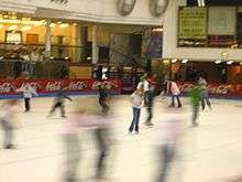
One of the most significant buildings of an earlier phase of development was Dollan Baths leisure complex (opened 1968) which has category A listed status. The Dollan Baths are the subject of a local urban myth, which told that the pool was built 5 cm short of Olympic size. In fact, the pool was built as 55 yards (50 m) long, but is only six lanes wide, rather than the Olympic standard of 50m and ten lanes wide. The Aqua Centre re-opened on 28 May 2011 after a major refurbishment costing £6.5 million. Facilities include swimming pool with moveable floor, health suite and fitness gym. The famous glass wall allowing views from the reception area into the pool remains.
Hunter House Museum
Contains exhibits relating to medical pioneers, William and John Hunter, who were born in the area. In recent years the Hunter House was bought by the neighbouring Calderwood Baptist Church. The building was refurbished and is now used for meetings, groups and functions as well as housing some exhibits from its previous life as a museum. The building also houses a café.
St. Brides's Church
Langlands Moss
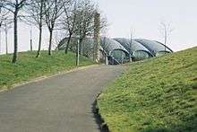
A local nature reserve which comprises a Lowland Raised Peat Bog, a UK BAP priority habitat. The reserve is owned by South Lanarkshire Council and maintained by The Friends of Langlands Moss L.N.R. A boardwalk allows visitors to walk over the reserve safely while observing the wildlife which lives on the Moss – many species here occur only in Bog habitats making this site one of special importance. Located just south of East Kilbride, the reserve is accessed easiest from the A726, heading towards Langlands Golf Course & Auldhouse.
Whitelee Windfarm
Whitelee Wind Farm, Europe's largest on shore wind farm, is located near Eaglesham, to the south of East Kilbride.
Parks and sports
East Kilbride from the Scottish Lowland Football League, is based in the town, and play at the K Park Training Academy at Calderglen Country Park.
East Kilbride Thistle Juniors also operate from The Show Park in The Village.
East Kilbride YM FC is the town's oldest football club, founded in 1936. They currently have three men's, under-17's and veterans' sides. EKYM are also part of the East Kilbride YMC Community Club which encompasses East Kilbride YM, East Kilbride Youth Club FC and East Kilbride Girls providing a football pathway from under-5's to adults.
East Kilbride RFC were formed in 1968 and are based at the Torrance House Arena, at Calderglen Country Park. From 1976 they rose steadily through the leagues, peaking for three years in Premier 2. They now play in the West Regional League 1, the fourth tier of club rugby. They run two senior men's teams and numerous youth teams which are linked to the local schools. Current Scotland national player, Alasdair Strokosch, played through all the youth levels at EKRFC.[19]
East Kilbride Lawn Tennis Club is one of the oldest tennis club in Scotland.
East Kilbride Pirates are the country's top American Football team and play in the BAFA Community Leagues.
EK82 Handball Club Founded in 1972, they train at the John Wright Sports Centre and the Alistair McCoist Complex. They play in the Scottish National League.
Athletics in the town is covered by three athletics clubs: Whitemoss, East Kilbride and Calderglen. Both Whitemoss and East Kilbride Athletic Club are based at the John Wright Sports centre.
Greenhills Dynamo is an amateur football side set up in 1998. Since its formation, the team has enjoyed relative success in the Strathclyde Saturday Morning League, winning seven trophies in 13 years. They won the Premier Division in Season 2009–10 under the management of Tommy Livingston and his assistant Dougie Craggs.[20]
Twin town
Notable people
- William Allison, former member of the Wisconsin State Assembly
- Alex Ferguson, former manager of Manchester United F.C, is a former resident of the town
- Kate Dickie, actress who appeared in the HBO series Game of Thrones and the 2012 film Prometheus, was born in East Kilbride
- Blythe Duff, Scottish theatre and television actress of Taggart fame, was born and raised in East Kilbride.
- Liam Fox, Conservative MP for North Somerset, was born and raised in the town
- Roddy Frame, frontman of Scottish indie band Aztec Camera, was born in the town
- Muriel Gray, journalist and broadcaster, was born in the town
- John Hannah, actor, was at one time resident in East Kilbride in the Murray area
- Iain Harvie, guitarist with Scottish rock band Del Amitri, was an East Kilbride resident
- Blue Bradford, SNP Member of the Scottish Youth Parliament for East Kilbride
- Hiding Place, a Scottish rock band, were formed in East Kilbride
- William and John Hunter, medical pioneers, were born at Long Calderwood within the present-day area of East Kilbride
- Peter King, renowned artist was born and brought up in East Kilbride
- The Jesus and Mary Chain, a Scottish alternative rock band, were formed in East Kilbride
- Lorraine Kelly, television presenter for GMTV, moved to the town with her family when she was aged 13
- Ally McCoist, Scottish former professional footballer, lead actor in A Shot at Glory, and former manager of Rangers F.C., was brought up in the town
- Mark McGuigan, footballer for Albion Rovers, was born in the town
- Ross Montgomery, Scottish darts player and resident of East Kilbride
- Julie Wilson Nimmo, actress who starred as children's favourite Miss Hoolie in the BBC TV programme Balamory, was born in the town
- George Orwell wrote part of his novel Nineteen Eighty-Four while convalescing from tuberculosis at Hairmyres Hospital in East Kilbride in late 1947 and much of 1948
- David Proctor, footballer, former Dundee United and Inverness Caledonian Thistle defender
- Jim and William Reid, brothers and the principal members of The Jesus and Mary Chain, were born and brought up in the town
- David R. Ross, writer and historian, moved to East Kilbride as a child and resided in the town until his death
- Allan Scott, athlete who represented Great Britain at the 2008 Beijing Olympics, holder of the Scottish 60m hurdle record, was raised in the town
- David Scott, singer-songwriter of The Pearlfishers has many produced notable records from a recording studio in the East Kilbride Arts Centre
- Adam Sinclair, TV actor for Mile High and other now the new star of movie adaptation of Irvine Welsh's Ecstasy released April 2012
- Iain Stewart, Professor in Geology, Television Presenter and Actor was born and raised in East Kilbride.
- Adair Turner, former Director-General of the Confederation of British Industry (CBI), lived there during his youth
- Marc Warren, Scottish professional golfer, lived and grew up in town, playing at East Kilbride Golf Club
- Robbie Winters, Scottish footballer, was born in the town
- Frazer Wright, Scottish Premiership footballer for St Johnstone FC was brought up in the town.
- Kirsty Young, Scottish television and radio presenter and actress, was born in the town.
References
- ↑ "Find out about an area". Scotland's Census. The Scottish Government. Retrieved 14 November 2013.
- ↑ "Scottish Civil Parishes Index map" (PDF). General Register Office for Scotland. Retrieved 26 September 2013.
- ↑ "List of UK post towns". Evox Facilities. Archived from the original on 19 February 2012. Retrieved 22 February 2012.
- ↑ "TGS – 1950s to The Present Day – Neighbourhoods – New Towns". Theglasgowstory.com. Retrieved 13 November 2012.
- ↑ Cowling, D. (1997). An Essay for Today: the Scottish New Towns 1947–1997. Edinburgh: Rutland Press.
- ↑ List of Mod's places for each year on Sabhal Mòr Ostaig website
- ↑ "Redeveloping East Kilbride Town Centre". Eastkilbride.org.uk. Retrieved 14 November 2012.
- ↑ "UK | Scotland | New town could get £400m facelift". BBC News. 2 April 2006. Retrieved 14 November 2012.
- ↑ "How to find Abercrombie House, East Kilbride". DFID. 14 December 2009. Retrieved 13 November 2012.
- ↑ "About Us – Westwoodhill Evangelical Church". Retrieved 3 March 2015.
- ↑ "East Kilbride". Search For Hope. Retrieved 14 November 2012.
- ↑
- ↑
- ↑ "UK | Scotland | Glasgow, Lanarkshire and West | New Zealand city to get Whirlies". BBC News. 7 April 2008. Retrieved 14 November 2012.
- ↑ "Welcome to Polo Mint city!". Evening Times. 25 June 2010. Retrieved 13 November 2012.
- ↑ "East Kilbride Bus Station". SPT. Retrieved 4 March 2015.
- ↑ Farrelly, Tony. "New cycle route opens between Glasgow and East Kilbride". road.cc. Retrieved 1 March 2015.
- ↑ "East Kilbride cycle network, Routes one to three". southlanarkshire.gov.uk. South Lanarkshire Council. Retrieved 1 March 2015.
- ↑ http://www.pitchero.com/clubs/eastkilbriderugbyclub/a/ekrfc-history-8814.html
- ↑ http://www.clubwebsite.co.uk/greenhillsdynamo/77787/SeasonArchive/match_report/2158997?archive_id=30687
- ↑ Lynda Nicol (9 May 2012). "Danish orchestra set to play in joint Lanarkshire spectacular". East Kilbride News. Retrieved 12 November 2013.
External links
| Wikimedia Commons has media related to East Kilbride. |
- East Kilbride at DMOZ
- Interactive picture guide of East Kilbride
- East Kilbride Thistle Football Club