East Point, Hong Kong
| East Point, Hong Kong | |||||||||||||
|
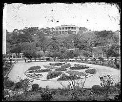
Jardine's Garden and House at East Point c.1868. Photograph by John Thomson. | |||||||||||||
| Traditional Chinese | 東角 | ||||||||||||
|---|---|---|---|---|---|---|---|---|---|---|---|---|---|
| Simplified Chinese | 东角 | ||||||||||||
| |||||||||||||

East Point was a cape on the northern shore of Hong Kong Island, Hong Kong. It was a pointed headland that extended from Jardine's Hill, i.e. Lee Garden towards Kellett Island. It marked the eastern limits of the early City of Victoria. The piece of land separated Causeway Bay in the east and the bay outside Happy Valley. Streams and muds from Tai Hang and Wong Nai Chung (now buried beneath Canal Road) shaped the headland.
Geography
Two sides of the cape were reclaimed over a hundred years. The first stage was in the mid-19th century. The east of the cape was reclaimed to the edge of Victoria Park and the west to Hennessy Road. The second stage was between World War I and World War II. Its west was reclaimed to Gloucester Road. The shape of the cape was mostly lost. For the construction of Cross Harbour Tunnel, further reclamation extended the land to Kellett Island and the cape was completely buried.
Physically, the Causeway Bay Station of the MTR and World Trade Centre are built on the body of East Point. Windsor House and Paterson Street fall on its first stage reclamation. The above two areas were referred to as East Point, while to its west was Ngo Keng.
Large scale reclamations make the geographic feature and division less obvious. Causeway Bay originally referred to the circular tung lo-shaped bay. It also referred to the east shore of the bay, i.e. the present-day area in Tin Hau Station. It gradually replaced East Point as the name of that area.
History
Much of the land of East Point was historically in the hands of Jardine Matheson, which had their original Hong Kong godowns and offices there. Swire once had a sugar refinery in Sugar Street.
Legacy
The name East Point is still found in East Point Road (東角道) and East Point Centre (東角中心).
See also
External links
| Wikimedia Commons has media related to East Point, Hong Kong. |
- Gwulo entry
- Jardine, Matheson & Co. afterwards Jardine, Matheson & Co. Limited: an outline of the history of a China House for a hundred years 1832-1932, Hong Kong: Privately Printed, 1934.Extract: Illustrations facing pages 12, 16, 26, & pp. 26-27
Coordinates: 22°16′49″N 114°11′05″E / 22.28028°N 114.18472°E