Easton, Cambridgeshire
| Easton | |
 St Peter's Church, Easton |
|
 Easton |
|
| Population | 169 (2011) |
|---|---|
| OS grid reference | TL1371 |
| District | Huntingdonshire |
| Shire county | Cambridgeshire |
| Region | East |
| Country | England |
| Sovereign state | United Kingdom |
| Post town | Huntingdon |
| Postcode district | PE28 |
| Dialling code | 01480 |
| Police | Cambridgeshire |
| Fire | Cambridgeshire |
| Ambulance | East of England |
| EU Parliament | East of England |
|
|
Coordinates: 52°19′48″N 0°20′09″W / 52.3299°N 0.3358°W
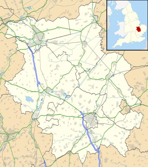
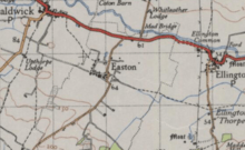
Easton is a village and civil parish in Cambridgeshire, England.[1] Easton lies approximately 6 miles (10 km) west of Huntingdon, between the villages of Ellington and Spaldwick. Easton is situated within Huntingdonshire which is a non-metropolitan district of Cambridgeshire as well as being a historic county of England. Easton is a hamlet which the Anglo Saxons settled in.
St Peter's Church
Easton is home to St Peter's Church which was built in the 11th Century, partially reconstructed in the 13th and 14th century and majorly rebuilt in 1781.[2] It was said in 1872 'The church is good; and there are a Wesleyan chapel'.[3]
Thirteen years after St Peter's Church became a grade 1 listed building in 1958,[4] it was made redundant[2] and became part of The Churches Conservation Trust in 1971.[5] Since the renovation, St Peter's has been described as 'a simple, elegant gem of a building'.[6]
Socio-economic statistics
Population
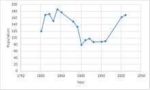
In 1801, the population of Easton was 120 people:[7] 57 males and 63 females,[8] drastically increasing to 172 people:[7] 82 males and 90 females by 1821.[8] The population then fluctuated for the next fifty years, peaking at 186 people:[7] 95 males and 91 females[8] in 1841 and lulling at 133 people:[7] 70 males and 63 females[8] in 1891. Only ten years later, by 1901, the population had dropped to only 79 people:[7] 42 males and 37 females[8] before increasing again to 93 people:[7] 45 males and 48 females[8] in 1911 and remaining between a population of 93 to 98 people until 1961.[7] At the time of the 2001 census, the parish's population had greatly increased to 162: 80 males and 82 females across 60 households.[9] However, by 2011, the population had increased only slightly to 169 people: 83 males and 86 females across 65 households.[10]
Population Density
In 1880, the population density of Easton was 0.125 people per hectare, dropping to 0.0625 people per hectare in 1900 where it remained fairly constant until 1960.[11] However, by 2001, the population density had increased to 0.3 people per hectare[12] and remained the same until 2011.[13]
Age structure
In 2001, almost half, 49%, of Easton's residents were in the 30–59 years age bracket, with 39 people aged 30–44 and 39 people aged 45–59.[14] Additionally, there were 7 people aged 55, 7 people aged 51 and 7 people aged 53,[15] making these individual ages dominant within the Parish. However, by 2011, residents ages became more diverse as the majority were aged 45–59, 25.4% of the total population. Furthermore, Easton had a mean age of 44.2 years, above both Huntingdonshire's average age of 39.9 years and the national average age of 39.3 years showing Easton as having a slightly older population in comparison.[16]
Occupation
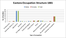
In 1881, male and female occupations drastically differentiated as 16 males worked in Agriculture and 16 females worked in Unknown Occupations. Therefore, Agriculture was the most popular occupation for males and Textile Fabrics / Dress was the most popular known occupation for females as it provided them with 6 jobs.[17]
This contrasts to leading occupations in 2001 as 23 males were Managers and Senior Officials,[18] and 13 females worked in Administrative and Secretarial occupations[19] making them the most popular sectors. By 2011, the number of male Managers and senior officials had dropped to 16, but it remained their most popular occupation.[20] Similarly, the number of females occupied by Administrative and Secretarial jobs had also decreased, to 6, but it was no longer the most popular occupation as the number of female Professionals increased to 9, making being a Professional the most popular occupation in 2011.[21]
Housing
In 1831, 36 houses in Easton were occupied with no vacant houses in the area.[22] However, by 1851, 36 houses remained occupied, with 7 vacant and 2 under construction.[22] This reflects the population increase of 35 people between 1831 and 1841,[23] and so the data indicates the Parish may have been constructing new homes to cater for the influx of people. By 1901, the figures had dropped to the lowest point with only 21 occupied houses and 5 vacant[22] which once again reflects the decrease in population as it drops from 133 residents to just 79.[23] However, twenty years later in 1921, the number of occupied houses had increase again reaching 25 households. This figure fluctuated between 25 and 32 houses occupied up until 1961.[22]
By 2001, the number of households in Easton had almost doubled with 60 occupied houses. There were 3 additional unoccupied houses which were only unoccupied as they were holiday homes or second residency homes.[24]
History
In 1085 William the Conqueror ordered that a survey should be carried out across his kingdom to discover who owned which parts and what it was worth. The survey took place in 1086 and the results were recorded in what, since the 12th century, has become known as the Domesday Book. Starting with the king himself, for each landholder within a county there is a list of their estates or manors; and, for each manor, there is a summary of the resources of the manor, the amount of annual rent that was collected by the lord of the manor both in 1066 and in 1086, together with the taxable value.[25] In 1086 there were ten manors at Easton; the annual rent paid to the lords of the manors in 1066 had been £10.55 and the rent had increased to £11.35 in 1086.[26]
The Domesday Book uses a number of units of measure for areas of land that are now unfamiliar terms, such as hides and ploughlands. In different parts of the country, these were terms for the area of land that a team of eight oxen could plough in a single season and are equivalent to 120 acres (49 hectares). By 1086, the hide had become a unit of tax assessment rather than an actual land area; a hide was the amount of land that could be assessed as £1 for tax purposes. The survey records that there were 19.5 ploughlands at Easton in 1086.[26] In addition to the arable land, there was 840 acres (340 hectares) of meadows at Easton.[26]
The tax assessment in the Domesday Book was known as geld or danegeld and was a type of land-tax based on the hide or ploughland. It was originally a way of collecting a tribute to pay off the Danes when they attacked England, and was only levied when necessary. Following the Norman Conquest, the geld was used to raise money for the King and to pay for continental wars; by 1130, the geld was being collected annually. Having determined the value of a manor's land and other assets, a tax of so many shillings and pence per pound of value would be levied on the land holder. While this was typically two shillings in the pound the amount did vary; for example, in 1084 it was as high as six shillings in the pound. For the manors at Easton the total tax assessed was 9.3 geld.[26]
Government
Easton was in the historic and administrative county of Huntingdonshire until 1965. From 1965, the village was part of the new administrative county of Huntingdon and Peterborough. Then in 1974, following the Local Government Act 1972, Easton became a part of the county of Cambridgeshire.
The second tier of local government is Huntingdonshire District Council which is a non-metropolitan district of Cambridgeshire and has its headquarters in Huntingdon. Huntingdonshire District Council has 52 councillors representing 29 district wards.[27] Easton is a part of the district ward of Ellington and is represented on the district council by one councillor.[27][28]
For Easton the highest tier of local government is Cambridgeshire County Council which has administration buildings in Cambridge. Cambridgeshire County Council consists of 69 councillors representing 60 electoral divisions.[29] Easton is part of the electoral division of Sawtry and Ellington[28] and is represented on the county council by one councillor.[29]At Westminster Easton is in the parliamentary constituency of North West Cambridgeshire,[28] and elects one Member of Parliament (MP) by the first past the post system of election. Easton is represented in the House of Commons by Shailesh Vara (Conservative) and has been since 2005. The previous member of parliament was Brian Mawhinney (Conservative) who represented the constituency between 1997 and 2005. For the European Parliament Easton is part of the East of England constituency which elects seven MEPs using the d'Hondt method of party-list proportional representation.
References
- ↑ Ordnance Survey: Landranger map sheet 153 Bedford & Huntingdon (St Neots & Biggleswade) (Map). Ordnance Survey. 2013. ISBN 9780319231722.
- 1 2 "Cambridgeshire Churches". Retrieved 17 March 2016.
- ↑ Wilson, John Marius (1870–72). Imperial Gazetteer of England and Wales. Edinburgh: A. Fullerton & Co.
- ↑ "Parish Church of St Peter, Easton". British Listed Buildings. Retrieved 17 March 2016.
- ↑ "Complete list of our churches". The Churches Conservation Trust. Retrieved 17 March 2016.
- ↑ "St Peter's Church, Cambridge, Cambridgeshire". Retrieved 17 March 2016.
- 1 2 3 4 5 6 7 "Easton AP/CP". A Vision of Britain through Time. GB Historical GIS / University of Portsmouth. Retrieved 19 March 2016.
- 1 2 3 4 5 6 "Easton AP/CP". A Vision of Britain through Time. GB Historical GIS / University of Portsmouth. Retrieved 19 March 2016.
- ↑ "Easton CP: Parish Headcounts, 2001". Neighbourhood Statistics. Office for National Statistics. Retrieved 22 April 2016.
- ↑ "Key Figures for 2011 Census: Key Statistics". Neighbourhood Statistics. Office for National Statistics. Retrieved 18 March 2016.
- ↑ "Easton AP/CP". A Vision of Britain Through Time. GB Historical GIS / University of Portsmouth. Retrieved 19 March 2016.
- ↑ "Population Density, 2001 (UV02)". Neighbourhood Statistics. Office for National Statistics. Retrieved 19 March 2016.
- ↑ "Population Density, 2011 (QS102EW)". Neighbourhood Statistics. Office for National Statistics. Retrieved 19 March 2016.
- ↑ "Age Structure, 2001 (KS02)". Neighbourhood Statistics. Office for National Statistics. Retrieved 18 March 2016.
- ↑ "Age, 2001 (UV04)". Neighbourhood Statistics. Office for National Statistics. Retrieved 18 March 2016.
- ↑ "Age Structure, 2011 (KS102EW)". Neighbourhood Statistics. Office for National Statistics. Retrieved 18 March 2016.
- ↑ "1881 Census of England and Wales". A Vision of Britain through Time. GB Historical GIS / University of Portsmouth. Retrieved 22 April 2016.
- ↑ "Occupation Groups – Males, 2001 (KS12B)". Neighbourhood Statistics. Office for National Statistics. Retrieved 21 April 2016.
- ↑ "Occupation Groups – Females, 2001 (KS12C)". Neighbourhood Statistics. Office for National Statistics. Retrieved 21 April 2016.
- ↑ "Occupation – Males, 2011 (KS609EW)". Neighbourhood Statistics. Office for National Statistics. Retrieved 21 April 2016.
- ↑ "Occupation – Females, 2011 (KS610EW)". Neighbourhood Statistics. Office for National Statistics. Retrieved 21 April 2016.
- 1 2 3 4 "Easton AP/CP". A Vision of Britain Through Time. GB Historical GIS / University of Portsmouth. Retrieved 18 March 2016.
- 1 2 "Easton AP/CP". A Vision of Britain Through Time. GB Historical GIS / University of Portsmouth. Retrieved 18 March 2016.
- ↑ "Housing Stock, 2001 (UV53)". Neighbourhood Statistics. Office for National Statistics. Retrieved 18 March 2016.
- ↑ Dr Ann Williams, Professor G.H. Martin, eds. (1992). Domesday Book: A Complete Translation. London: Penguin Books. pp. 551–561. ISBN 0-141-00523-8.
- 1 2 3 4 Professor J.J.N. Palmer, University of Hull. "Open Domesday: Place – Easton". www.opendomesday.org. Anna Powell-Smith. Retrieved 25 February 2016.
- 1 2 "Huntingdonshire District Council: Councillors". www.huntingdonshire.gov.uk. Huntingdonshire District Council. Retrieved 23 February 2016.
- 1 2 3 "Ordnance Survey Election Maps". www.ordnancesurvey.co.uk. Ordnance Survey. Retrieved 23 February 2016.
- 1 2 "Cambridgeshire County Council: Councillors". www.cambridgeshire.gov.uk. Cambridgeshire County Council. Retrieved 15 February 2016.
External links
![]() Media related to Easton, Cambridgeshire at Wikimedia Commons
Media related to Easton, Cambridgeshire at Wikimedia Commons