Easton, Lincolnshire
| Easton | |
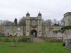 Easton Walled Gardens |
|
 Easton |
|
| OS grid reference | SK940267 |
|---|---|
| – London | 90 mi (140 km) S |
| District | South Kesteven |
| Shire county | Lincolnshire |
| Region | East Midlands |
| Country | England |
| Sovereign state | United Kingdom |
| Post town | GRANTHAM |
| Postcode district | NG33 |
| Police | Lincolnshire |
| Fire | Lincolnshire |
| Ambulance | East Midlands |
| EU Parliament | East Midlands |
|
|
Coordinates: 52°49′44″N 0°36′22″W / 52.829°N 0.6061°W
Easton is a village and civil parish in the South Kesteven district of Lincolnshire, England. It is situated almost 2 miles (3.2 km) north from Colsterworth, and 1 mile (1.6 km) east from the A1 road. The population is included in the civil parish of Stoke Rochford.
History
The village has no church, but is part of the North and South Stoke with Easton Parish, which contains the church of St Andrew and St Mary at Stoke Rochford, situated just inside Easton civil parish. The A1 within the parish was straightened when converted to a dual-carriageway in 1960. The village is still largely the same size as it was at the time of the Domesday Book.
Easton Hall
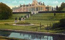
Sir Henry Cholmeley bought the manor in 1592; his direct descendant Sir Montague Cholmeley rebuilt the village in the early 19th century. Easton Hall was built by Sir Henry Cholmeley, partly rebuilt in 1805, and enlarged in the Victorian period. It was damaged while being used by the army during the Second World War, and was pulled down in 1951. The 12 acres of gardens were abandoned in 1951 but a major renovation project began in 2001.[1] The Cholmeley family still live in the village and are responsible for the 2005 renovation of the hall's gardens.[2][3]
See also
Destruction of country houses in 20th-century Britain
Geography
The River Witham passes through the village,[4] and just south of the village it crosses the A1 inside the parish of Colsterworth. Although the village, which has a population of 100, is technically a civil parish, in practice it is shared for administrative and religious purposes with Stoke Rochford. The combined parish is one of the largest by area in South Kesteven, stretching along the B6403 (High Dike - Ermine Street) from the A1 to the East Coast Main Line bridge.
A railway used to join the ECML at the B6403 road bridge and followed the eastern side of the B6403 to Woolsthorpe. The road connecting Stoke Rochford to the B6403 is Easton Lane. The Easton civil parish stretches along the B6403 from the A1 to the junction of this road; it also includes the southern part of Stoke Rochford village, including its parish church[5] and post office. In the south-east of the parish is Easton Wood.
Cold store
Nearby on the B6403 is Easton Cold Store, a frozen vegetable processing factory, owned by PAS. It was bought by McCain in 1982.
References
- ↑ "History". Easton Walled Gardens. Retrieved 28 August 2011.
- ↑ " Easton Walled Gardens", Geograph.org.uk. Retrieved 25 July 2011
- ↑ "Secret garden gets Tudor makeover", BBC News, 13 July 2002. Retrieved 25 July 2011
- ↑ "Bridge over the Witham", Geograph.org.uk. Retrieved 25 July 2011
- ↑ "St.Andrew & St.Mary's church, Stoke Rochford, Lincs", Geograph.org.uk. Retrieved 25 July 2011
External links
 Media related to Easton, Lincolnshire at Wikimedia Commons
- Easton Walled Gardens website
- The Easton Estate website
- Statistics about Easton, South Kesteven
- Stoke Rochford and Easton Parish Council
England Portal | |
| Unitary authorities | |
| Boroughs or districts | |
| Major settlements |
|
| Topics | |