Egge, Sogn og Fjordane
| Egge | |
|---|---|
| Village | |
|
The village is located at the right base of the mountain Eggenipa | |
 Egge  Egge Location in Sogn og Fjordane | |
| Coordinates: 61°41′13″N 06°31′24″E / 61.68694°N 6.52333°ECoordinates: 61°41′13″N 06°31′24″E / 61.68694°N 6.52333°E | |
| Country | Norway |
| Region | Western Norway |
| County | Sogn og Fjordane |
| District | Nordfjord |
| Municipality | Gloppen |
| Time zone | CET (UTC+01:00) |
| • Summer (DST) | CEST (UTC+02:00) |
| Post Code | 6826 Byrkjelo |
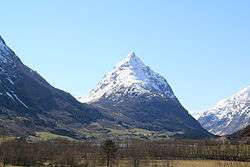
Egge is a village in the municipality of Gloppen in Sogn og Fjordane county, Norway. It is located along the European route E39 highway, about 5 kilometres (3.1 mi) south of the village of Byrkjelo, and about 7 kilometres (4.3 mi) west of Jostedalsbreen National Park where the Myklebustbreen glacier is located. Egge is 21 kilometres (13 mi) southeast of the municipal center of Sandane, and it is also about 13 kilometres (8.1 mi) north of Skei, the municipal center of neighboring Jølster. The village sits at the base of the mountain Eggenipa.[1]
References
This article is issued from Wikipedia - version of the 8/1/2016. The text is available under the Creative Commons Attribution/Share Alike but additional terms may apply for the media files.