Eightmile Island
| Geography | |
|---|---|
| Location | Ohio River, West Virginia |
| Coordinates | 38°56′24″N 82°06′19″W / 38.9400792°N 82.1051436°WCoordinates: 38°56′24″N 82°06′19″W / 38.9400792°N 82.1051436°W |
| Administration | |
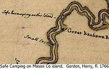
Gordon's 1766 Colonial Patrol Map.
Eightmile Island is a forested island on the Ohio River in Mason County, West Virginia. The island is located directly across the river from the village of Cheshire, Ohio and American Electric Power Company power plant facilities there.
The map is a clip from Harry Gordon's map (ca 1766) showing the "Indian Trade" safe camp site when on the main canoe route.
See also
This article is issued from Wikipedia - version of the 9/4/2016. The text is available under the Creative Commons Attribution/Share Alike but additional terms may apply for the media files.