Eilean na Cille
| Gaelic name | Eilean na Cille |
|---|---|
| Meaning of name | church island |
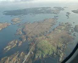 Eilean na Cille (at right), Triallabreac and Wiay from the air | |
| Location | |
 Eilean na Cille Eilean na Cille shown within the Outer Hebrides | |
| OS grid reference | NF846459 |
| Physical geography | |
| Island group | Uist and Barra |
| Area | 16 hectares (40 acres)[1] |
| Highest elevation | 20 m (66 ft) |
| Administration | |
| Sovereign state | United Kingdom |
| Country | Scotland |
| Council area | Na h-Eileanan Siar |
| References | [2][3] |
Eilean na Cille, south east of Benbecula is an island of the Outer Hebrides connected to Grimsay (South) by a causeway which carries the B891. The road was built to service the pier at Peter's Port, which was constructed in 1896 at cost of £2,000 - although the anchorage is awkward and should not be used without local knowledge.[4]
Eilean na Cille is "included in the NRS statistical geography for inhabited islands but had no usual residents at the time of either the 2001 or 2011 censuses".[5]
Notes
- ↑ Rick Livingstone’s Tables of the Islands of Scotland (pdf) Argyll Yacht Charters. Retrieved 12 Dec 2011.
- ↑ Ordnance Survey. Get-a-map (Map). 1:25,000. Leisure. Ordinance Survey. Retrieved 21 August 2013.
- ↑ Mac an Tàilleir, Iain (2003) Ainmean-àite/Placenames. (pdf) Pàrlamaid na h-Alba. Retrieved 26 August 2012.
- ↑ Haswell-Smith (2004) p. 243
- ↑ National Records of Scotland (15 August 2013) (pdf) Statistical Bulletin: 2011 Census: First Results on Population and Household Estimates for Scotland - Release 1C (Part Two). "Appendix 2: Population and households on Scotland’s inhabited islands". Retrieved 17 August 2013.
References
- Haswell-Smith, Hamish (2004). The Scottish Islands. Edinburgh: Canongate. ISBN 978-1-84195-454-7.
|  | ||||||||||||||||||||||||||||
|
| |||||||||||||||||||||||||||||
| |||||||||||||||||||||||||||||
| |||||||||||||||||||||||||||||
| |||||||||||||||||||||||||||||
| |||||||||||||||||||||||||||||
| |||||||||||||||||||||||||||||
| |||||||||||||||||||||||||||||
Coordinates: 57°23.4′N 7°15.5′W / 57.3900°N 7.2583°W
This article is issued from Wikipedia - version of the 9/13/2013. The text is available under the Creative Commons Attribution/Share Alike but additional terms may apply for the media files.