Eitzing
| Eitzing | ||
|---|---|---|
.jpg) | ||
| ||
 Eitzing Location within Austria | ||
| Coordinates: 48°0′0″N 13°0′0″E / 48.00000°N 13.00000°ECoordinates: 48°0′0″N 13°0′0″E / 48.00000°N 13.00000°E | ||
| Country | Austria | |
| State | Upper Austria | |
| District | Ried im Innkreis | |
| Government | ||
| • Mayor | Friedrich Freund (ÖVP) | |
| Area | ||
| • Total | 8.6 km2 (3.3 sq mi) | |
| Elevation | 423 m (1,388 ft) | |
| Population (1 January 2016)[1] | ||
| • Total | 769 | |
| • Density | 89/km2 (230/sq mi) | |
| Time zone | CET (UTC+1) | |
| • Summer (DST) | CEST (UTC+2) | |
| Postal codes | 4970, 4971, 4973 und 4941 | |
| Area codes | 07752, 07751 | |
| Vehicle registration | RI | |
| Website | www.eitzing.at | |

Eitzing is a municipality in the district of Ried im Innkreis in the Austrian state of Upper Austria.
Geography
Eitzing is situated 419 m above sea level in the Innviertel. Its dimensions are 4,6 km from the North to the South and 4,3 km from the West to the East. The complete area accounts for 8,62 km². 13,8% of the land is afforested, 77% is used agriculturally. Parts of the municipality are Amerika, Bankham, Ertlberg, Hofing, Kirchberg, Obereitzing, Probenzing, Sausack, Untereitzing, Ursprung and Wöppelhub.
Population
| Historical population | ||
|---|---|---|
| Year | Pop. | ±% |
| 1869 | 658 | — |
| 1880 | 659 | +0.2% |
| 1890 | 640 | −2.9% |
| 1900 | 659 | +3.0% |
| 1910 | 656 | −0.5% |
| 1923 | 642 | −2.1% |
| 1934 | 652 | +1.6% |
| 1939 | 615 | −5.7% |
| 1951 | 724 | +17.7% |
| 1961 | 591 | −18.4% |
| 1971 | 596 | +0.8% |
| 1981 | 630 | +5.7% |
| 1991 | 630 | +0.0% |
| 2001 | 658 | +4.4% |
| 2013 | 728 | +10.6% |
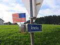 Amerika, an oddly named part of Eitzing
References
| Wikimedia Commons has media related to Eitzing. |
This article is issued from Wikipedia - version of the 3/5/2014. The text is available under the Creative Commons Attribution/Share Alike but additional terms may apply for the media files.