El Toro Wilderness
| El Toro Wilderness | |
|---|---|
|
IUCN category Ib (wilderness area) | |
 | |
| Location | El Yunque National Forest, Puerto Rico |
| Nearest city | Rio Grande, Puerto Rico |
| Coordinates | 18°16′13″N 65°49′44″W / 18.27028°N 65.82889°WCoordinates: 18°16′13″N 65°49′44″W / 18.27028°N 65.82889°W |
| Area | 10,000 acres (40.5 km2) |
| Established | December, 2005 |
| Governing body | United States Forest Service |
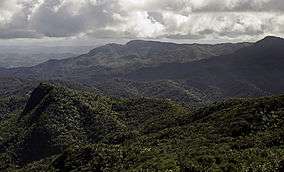
El Toro Wilderness (Spanish: Selva El Toro) is a 10,000-acre (40.5 km2) National Wilderness Preservation System unit located partly within El Yunque National Forest (formerly the Caribbean National Forest) on the island of Puerto Rico. El Toro, named after the highest peak in the forest at 3,524 feet (1,074 m), is the only tropical wilderness in the United States National Forest System.[1]
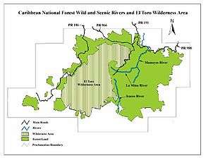
Caribbean National Forest map
El Toro is home to a variety of wildlife, including the critically endangered Puerto Rican parrot.
In descending order of land area the wilderness is located in parts of the municipalities of Río Grande, Naguabo, Las Piedras, and Canóvanas.
See also
References
- ↑ El Toro Wilderness fact sheet - U.S. Forest Service
External links
- El Toro Wilderness - USDA Forest Service
- El Toro Wilderness - Wilderness.net
This article is issued from Wikipedia - version of the 11/19/2016. The text is available under the Creative Commons Attribution/Share Alike but additional terms may apply for the media files.