Elbląg Canal
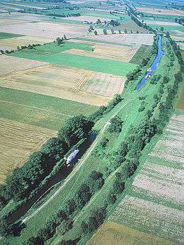
Elbląg Canal ([ˈɛlblɔŋk], Polish: Kanał Elbląski, German: Oberländischer Kanal) is a canal in Poland, in Warmian-Masurian Voivodeship, 80.5 km in length, which runs southward from Lake Drużno (connected by the river Elbląg to the Vistula Lagoon), to the river Drwęca and lake Jeziorak. It can accommodate small vessels up to 50 tons displacement. The difference in water levels approaches 100 m, and is overcome using locks and a remarkable system of tracks between lakes.
Today it is used mainly for recreational purposes. It is considered one of the most significant monuments related to the history of technology and was listed by Unesco as a memorial to world culture inheritances. In Poland it has recently been named one of Seven Wonders of Poland.[1] The canal was also named one of Poland's official national Historic Monuments (Pomnik historii), as designated January 28, 2011. Its listing is maintained by the National Heritage Board of Poland.
History
The canal was designed in 1825–44 by Georg Steenke, carrying out the commission given by the King of Prussia. Construction began in 1844. The difference in height over a 9.5 kilometres or 5.9 miles section of the route between the lakes was too great for building traditional locks; an ingenious system of inclined planes based on those used on the Morris Canal was employed instead, though the canal includes a few locks as well. There were originally four inclined planes with a fifth added later, replacing five wooden locks. Built under the name Oberländischer Kanal (Upper land Canal) and situated in the Kingdom of Prussia, it was opened on the 29 October 1860.[2] Since 1945 the canal is now in Poland. After wartime damage was repaired, it was restored to operation in 1948 and is now used for tourism.
The canal underwent renovation between 2011 and 2015 and is now again available for tourists.
Would-be Tourists might take note, in order to not be disappointed, the canal tours do not re-open after the winter season until May 1.
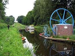
The Inclined Planes
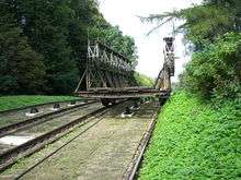
The four original inclined planes are in order from the summit level downwards, Buczyniec (Buchwalde) with a rise of 20.4m and a length of 224.8m, Katy (Kanten) with a rise of 18.83m and a length of 225.97m, Olesnica (Schönfeld) with a rise of 21.97m and a length of 262.63m and Jelenie (Hirschfeld) with a rise of 21.97m and a length of 263.63m.[3] The fifth incline was Calony Nowe (Neu-Kussfeld) with a rise of 13.72m, it was built to replace five wooden locks close to Elbląg.[2][4] They were constructed from 1860 to 1880.
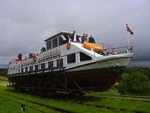
The canal worked independently of other waterways and as a result the boats were designed within the limits of the inclines. The boats had a maximum length of 24.48m, a maximum width of 2.98m and a maximum draught of 1.1m, they carried loads of about 50 tonnes.[2]
The inclines all consist of two parallel rail tracks with a gauge of 3.27m. Boats are carried on carriages which run on these rails. The inclines rise from the lower level of the canal to a summit and then down a second shorter incline to the upper canal level. The first part of the main incline and the short upper incline were both built at a gradient of 1:24. A carriage is lowered down the incline to counterbalance an upward moving carriage. Once the downward moving carriage has reached the summit and started down the main incline its weight helps pull up the upward moving carriage. This allowed the slope of the incline for this section to be built at a higher gradient of 1:12.[2]
See also
- Augustów Canal, linking the Vistula River with the Neman River
- Big Chute Marine Railway also carries boats in an open carriage instead of a water filled caisson.
- Boat lift
References
- ↑ (Polish) As per results of a plebiscite for the 'Seven Wonders of Poland' conducted by Rzeczpospolita (newspaper), cited at www.budowle.pl.
- 1 2 3 4 Uhlemann, Hans-Joachim. Canal Lifts and Inclines of the World.
- ↑ Permanent International Association of Navigation Congresses (1989). Ship lifts: report of a Study Commission within the framework of Permanent ... PIANC. ISBN 978-2-87223-006-8. Retrieved 2011-12-14.
- ↑ Tew, David. Canal Inclines and Lifts.
Further reading
- Tew, David (1984). Canal Inclines and Lifts. Sutton Books. ISBN 0-86299-031-9.
- Uhlemann, Hans-Joachim (2002). Canal lifts and inclines of the world (English Translation ed.). Internat. ISBN 0-9543181-1-0.
External links
| Wikimedia Commons has media related to Elbląg Canal. |
- Official webpage
- An Overland Canal Some old photos of the lift from 1937
- Photo gallery of the canal
- Warsaw Voice article
- A trip on the Elbląg Canal described by Michael Palin
Coordinates: 54°1′28″N 19°35′52″E / 54.02444°N 19.59778°E