Electoral district of Normanby (Victoria)
| Normanby Victoria—Legislative Assembly | |
|---|---|
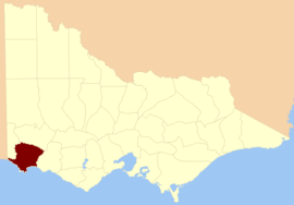 Location in Victoria | |
| State | Victoria |
| Created | 1856 |
| Abolished | 1904 |
| Demographic | Rural |
The Electoral district of Normanby was an electoral district in the Legislative Assembly of Victoria, it covered an area from the South Australian border to Portland Bay.[1]
Being defined in the Victoria Constitution Act 1855[2] as "Bounded on the North by the Grange Burn and River Wannon until the latter joins the River Glenelg; on the West by the River Glenelg to the Sea; on the South by the Sea Shore to the Mouth of the River Shaw; and on the East by the Western Branch of the River Shaw to its Source ; thence by a Line North to the Source of the Swamp Creek; by that Creek to Mount Napier Swamp ; and thence by a Line North Six Miles Fifteen Chains to the Grange Burn, including the Laurence’s and Lady Julia Percy’s Islands, excepting the Country included in the Electoral District of Portland" Coordinates: 38°0′S 141°30′E / 38.000°S 141.500°E
It was one of the districts in the inaugural Assembly.[3]
Normanby was abolished in 1904, part of its area was contained in the new Electoral district of Glenelg.[4]
Members for Normanby
| Name | Term |
|---|---|
| Edward Henty | Nov 1856 – Jul 1861 |
| George Levey | Aug 1861 – Dec 1867 |
| Thomas Cope | May 1868 – Apr 1877 |
| William Tytherleigh | May 1877 – Feb 1880 |
| William Shiels | May 1880 – May 1904 |
Shiels was Premier of Victoria from February 1892 to January 1893.[5]
References
- ↑ "Electoral districts of South Grant, North Grant, North Grenville, Ripon, Hampden, South Grenville and Polworth, Villiers and Heytesbury, Normanby, Dundas and Follett" (map). National Library of Australia.
- ↑ "Victoria Constitution Act 1855" (PDF). Retrieved 5 May 2013.
- ↑ Edward Sweetman (1920). Constitutional Development of Victoria, 1851-6. Whitcombe & Tombs Limited. p. 182. Retrieved 16 November 2012.
- ↑ "Electoral Districts Boundaries Act 1903". Australasian Legal Information Institute. Retrieved 21 January 2014.
- 1 2 "Re-Member (Former Members)". State Government of Victoria. Retrieved 16 November 2012.