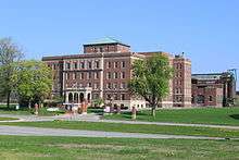
Eloise (psychiatric hospital)
Eloise was a large hospital complex located in Nankin Township in western Wayne County, Michigan. The name came from the post office on the grounds which opened July 20, 1894 and was named after Eloise Dickerson Davock,[1][2][3][4] daughter of Detroit's postmaster.
It operated from 1839 to early 1984 and started out as a poor house and farm but developed into an asylum and hospital. In 1832 it was called the Wayne County Poorhouse; in 1872 it was the Wayne County Alms House; in 1886 it was referred to simply as the Wayne County House. In 1913 there were three divisions: The Eloise Hospital(Mental Hospital), the Eloise Infirmary (Poorhouse) and the Eloise Sanitarium (T.B. Hospital) which were collectively called Eloise. In 1945 it was named Wayne County General Hospital and InfirmarAry at Eloise, Michigan. In 1974 it had two divisions - the Wayne County General Hospital and the Wayne County Psychiatric Hospital. The psychiatric division closed in 1977 and in 1979 it was officially called Wayne County General Hospital.[5] At its prime, Eloise consisted of 78 buildings and 902 acres (365 ha) of land. Now only ruins, sewer lids with Eloise Hospital engraved on them, 4 of the 78 buildings and the Eloise Cemetery remain.
The history of Eloise
The Wayne County Poor House was founded in 1832. It was located at Gratiot and Mt. Elliott Avenues in Hamtramck Township two miles from the Detroit city limits. By 1834 the poorhouse was in bad condition and 280 acres (110 ha) in Nankin Township were purchased. The Black Horse Tavern which served as a stagecoach stop between Detroit and Chicago was located on the property. In those days it was a two-day stagecoach ride from Hamtramck Township to Nankin Township. The register shows that on April 11, 1839 35 people were transferred from the poorhouse in Hamtramck Township to the new one in Nankin Township. 111 apparently refused to go to the "awful wilderness." Many were children and homes among the residents of the city may have been found for them.[1] The log cabin which was formerly the Black Horse Tavern became the keeper's quarters and in 1838-9 a frame building was put up to house the inmates. A frame cookhouse was erected in the back of the log building and was used for cooking for both inmates and the keeper's family.[2]
The complex was almost self-sufficient. It had its own police and fire department, railroad and trolley stations, bakery, amusement hall, laundries, and a powerhouse. It also had many farm buildings including a dairy herd and dairy barns, a piggery, a root cellar, a Tobacco curing building, and employee housing.
Eloise was one of the first if not the first hospital to use x-rays for diagnosis performed by Dr.Albarran. Patients came from Detroit and other communities to have x-rays done.[6] It also housed the first kidney dialysis unit in the State of Michigan and pioneered in the field of Music Therapy.
As the years went on the institution grew larger and larger, a reflection in the increases in the population of the Detroit area. From only 35 residents in 1839 the complex grew to about 10,000 residents at its peak during the Great Depression and then started to decrease. The farm operations ceased in 1958 and some of the large psychiatric buildings were vacated in 1973. The psychiatric division started closing in 1977 when the State of Michigan took over the psychiatric division. The general hospital closed in 1984.
Inventor Elijah McCoy may be its most famous former resident. He spent a year prior to his death as a patient in the Eloise Infirmary. There were other well-known people who died at Eloise including several baseball players. Among them are Jul Kustus (died April 27, 1916), Larry LeJeune (died April 21, 1952), Charlie Krause (died March 30, 1948) and Marty Kavanagh (died 1960) Musician Horace Flinders was also a patient, and received music therapy.[7][8]
Eloise present day
Today the land that once was Eloise has been developed into a strip mall, a golf course, and condominiums. There are only two buildings currently in use. One is "D" Building or the Kay Beard Building. At one time this was an administration building and it was also used for psychiatric admissions and apartments for some employees like the Catholic chaplain. The old commissary building is currently being used as a family homeless shelter.
The old fire hall (former psychiatric facility laundry), and the power house are still standing in ruins. The old bakery was lost to arson in April 2016, with charred ruins still standing as of May 16, 2016 (however, there are plans to raze and remove the remainder). The Eloise smokestack — emblazoned Eloise in brick — was deemed to be a hazard and was demolished in 2006.[9][10]
In 1979, the Walter P. Reuther Psychiatric Hospital, located near the northwest end of the former Eloise property, just southeast of the intersection of Merriman and Palmer Roads, was opened. The facility is currently operated by the Michigan Department of Community Health.[11] In 1996, Oakwood Health System opened an outpatient facility, the Adams Child & Adolescent Health Center, on the corner of Merriman and Palmer near Reuther Hospital.[12] Both facilities have Palmer Road addresses.
Eloise is featured in the book Annie's Ghosts: A Journey Into a Family Secret by Steve Luxenberg, which is about Luxenberg's secret aunt who was committed to the Eloise psychiatric hospital in the 1940s.[13][14]
The site is marked by a Michigan Historic Marker.[15]
Presently the site and cemetery are maintained by the Friends of Eloise.[16]
The site and the adjoining Eloise Cemetery are reputed to be haunted.[17][18]
Eloise is featured in the book "Detroit Breakdown" part of D.E. Johnson's Detroit mysteries series, a fictional story about the murder of patients at Eloise. [19]
References
Citations
- 1 2 Keenan, Stanislas M. (1913). History of Eloise (PDF). Detroit: Thos. Smith Press. pp. 15, 17–20. Retrieved May 10, 2014.
- 1 2 Ibbotson, Patricia (2002). Eloise Dickerson Davock. Eloise: Poorhouse, Farm, Asylum and Hospital 1839-1984. Charleston, SC: Arcadia Publishing. ISBN 0-7385-1954-5. Retrieved May 9, 2014.
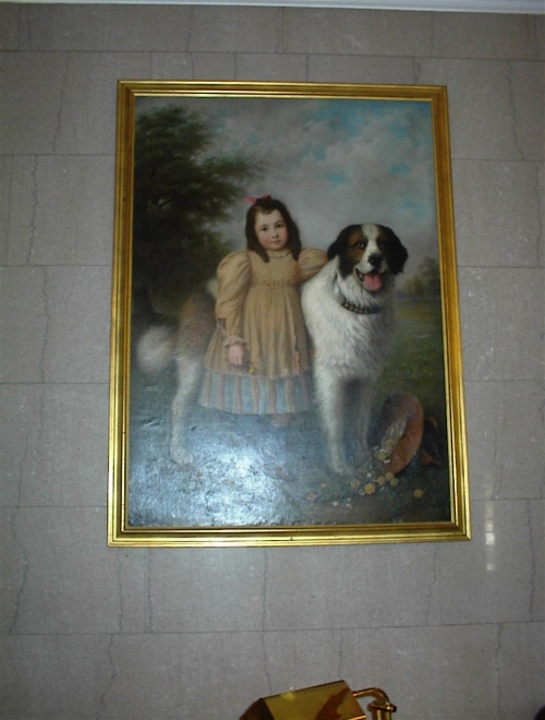
- ↑ "Entrance to Eloise Hospital, photograph of oil painting, Eloise with" (photograph). Retrieved May 9, 2014. St. Bernard
- ↑ Hawley, Darlene (January 12, 2014). "History of Eloise". The Wayne Dispatch. Retrieved May 9, 2014.
- ↑ Clark, Alvin C. (1982). A History of the Wayne County Infirmary, Psychiatric, and General Hospital Complex at Eloise, Michigan. Detroit: Wayne County General Hospital.
- ↑ Ibbotson, Patricia (2004). Detroit's Hospitals, Healers and Helpers. Charleston, SC: Arcadia Publishing. ISBN 0-7385-3223-1.
- ↑ "Genius In An Asylum 1946" (Film). British Pathé News. April 15, 1946. Retrieved May 11, 2014.
- ↑ "Genius In An Asylum 1946" (Film). British Pathé News/British Universities Film & Video Council. April 15, 1946. Retrieved May 11, 2014.
- ↑ "Old Eloise Asylum Smokestack From Roof" (photograph). Retrieved May 9, 2012.
- ↑ "Old Eloise Smokestack After Chunk Fell Off In 2005" (photograph). Retrieved May 9, 2012.
- ↑ "Walter P. Reuther Psychiatric Hospital". Michigan Department of Community Health. Retrieved May 5, 2014.
- ↑ "Oakwood Adams Child & Adolescent Health Center". Oakwood Health System. Retrieved May 5, 2014.
- ↑ See photo in Eloise: Poorhouse, Farm, Asylum and Hospital, page 109
- ↑ Luxenberg, Steve (May 11, 2010). Annie's Ghosts: A Journey Into a Family Secret (paperback) (Reprint ed.). New York: Hyperion. p. 432. ISBN 1401310192. ISBN 978-1401310196.
- ↑ "Eloise". Michigan Historical Markers Registered Site S0699. 2007. Retrieved May 4, 2014.
- ↑ "Friends of Eloise". Retrieved May 5, 2014.
- ↑ Baldassarro, R. Wolf (April 13, 2010). A Ghost Hunter's Field Guide (Paperback). lulu.com. p. 154. ISBN 978-0-557-05094-9. ISBN 0-557-05094-4. Retrieved May 5, 2014.
- ↑ wykedeyez. "Wayne County Poor House – Eloise Asylum". Retrieved May 6, 2014.
- ↑ Minotaur Books (September 4, 2012) ISBN 1250006627
References
- Clark, Alvin C. (1982). A History of the Wayne County Infirmary, Psychiatric, and General Hospital Complex at Eloise, Michigan. Detroit: Wayne County General Hospital.
- Baldassarro, R. Wolf (April 13, 2010). A Ghost Hunter's Field Guide (Paperback). lulu.com. p. 154. ISBN 978-0-557-05094-9. ISBN 0-557-05094-4. Retrieved May 5, 2014.
- Ibbotson, Patricia (2002). Eloise Dickerson Davock. Eloise: Poorhouse, Farm, Asylum and Hospital 1839-1984. Charleston, SC: Arcadia Publishing. ISBN 0-7385-1954-5. Retrieved May 9, 2014.
- Keenan, Stanislas M. (1913). History of Eloise (PDF). Detroit: Thos. Smith Press. Retrieved May 10, 2014.
- Luxenberg, Steve (May 11, 2010). Annie's Ghosts: A Journey Into a Family Secret (paperback) (Reprint ed.). New York: Hyperion. p. 432. ISBN 1401310192. ISBN 978-1401310196.
Further reading
- Wayne Co., Mich. Board of County Auditors. Research Bureau (1933). Report on analysis and survey of Eloise Hospital and Infirmary: prepared and issued by the County Research Bureau Division of Board of Wayne County Auditors. Report, Mich Wayne Co. Board of County Auditors. University of Chicago. Retrieved May 6, 2014.
External links
- Caring for the County’s Poor: a character repository of Eloise
- History of Eloise — Westland, Michigan
- Eloise Asylum, Asylum Projects, retrieved May 7, 2014
- nailhed (2004). "Eloise Asylum, 2004". Retrieved May 11, 2014.
Coordinates: 42°17′14″N 83°20′33″W / 42.28725°N 83.34261°W