EMH Regional Medical Center
| EMH Regional Medical Center | |
|---|---|
| EMH Regional Health System | |
|
| |
 | |
| Geography | |
| Location | Elyria, Ohio, USA |
| Organisation | |
| Care system | Private |
| Hospital type | Community |
| Affiliated university | Lorain County Community College |
| Services | |
| Beds | 438 |
| History | |
| Founded | October 30, 1908 |
| Links | |
| Website | http://www.emh-healthcare.org/Default.aspx |
EMH Regional Medical Center (formerly known as Elyria Memorial Hospital) is a hospital located in Elyria, OH. It is ranked as one of the Top 100 Hospitals in the US.[1] It serves the surrounding areas in Lorain County including North Ridgeville and Grafton.
History
Elyria Memorial Hospital is a hospital founded in 1908 in response to a trolley crash in Elyria, OH. Before the hospital was built, Elyria was in need of a hospital and when the accident happened, there was no place that was well suited to care for the 100 victims. Edgar F. Allen, whose son died in the crash, started to raise $100,000 to build a hospital. On October 30, 1908, Elyria Memorial Hospital was opened and soon after The Gates Hospital for Crippled Children was opened (Later to be named Gates Hospital). Since then EMH has been on the top 100 hospitals 10 times by Solucient.[2]
Elyria Campus
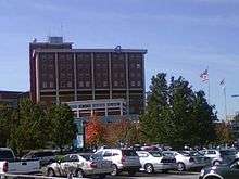
The main campus of the system is located in Elyria, OH which includes the original Allen Building (1908), the 11-floor Smythe Tower (originally constructed with 6 floors in 1962, later expanded to 11 floors with rooftop helipad in 1976) which is the tallest building in Elyria, the New West building (1972) which houses an emergency room and surgical suite, the New East building (1984) contains the Radiology department and several intensive care units, the Ambulatory Care Center (ACC, 1996) which contains the hospital's main lobby, patient registration, pre-admission testing, electrodiagnostics, outpatient surgery and the maternity unit. Just to the east of the main hospital, on the location of the former Gates Hospital for Crippled Children stands the Gates Building. Inside are the Gates Pharmacy, Auditorium, and three floors of doctors offices. On the second floor, the Gates building is linked to the New East building of the main hospital by an over-street walkway. On the opposite side of the main hospital, the ACC building is linked by another over-street walkway to a 4-floor parking garage.
Avon Campus
In 1997, EMH opened a campus just off of I-90 and OH-83 in Avon, OH. The new 91,000 square foot health and fitness center includes a free-standing 24/7 Emergency Department, an unprecedented medically based fitness center focusing on sports medicine and rehabilitation. Degreed and certified fitness instructors are available to work with members and can tailor a workout to any fitness level. Along with the top-of-the-line cardio and strength equipment, the Center offers free weights, two indoor pools, indoor racquetball and basketball courts, outdoor tennis and sand volleyball courts, a full-sized gym along with both an indoor and an outdoor track. Membership also includes day spa services, a comprehensive weight management service, and on-site child care provided by certified caregivers.
Amherst Campus
In Amherst, OH, The Hospital for Orthopaedic and Specialty Services is hospital for orthopaedic care and other related health issues. Prior to 2011, Amherst Hospital offered many of the same programs, treatments and facilities as the Elyria campus for several decades. However, budget constraints eventually caused deep changes in the Amherst campus and as of July 5, 2011, the removal of inpatient care and all surgeries effectively ended Amherst's role as a traditional hospital. While some functions, including the orthopedic Joint Camp and Acute Care for the Elderly (ACE) unit, were moved to the Elyria Campus, and many other services were moved to a new Orthopedics building in Sheffield, OH, the Amherst campus retained its 24/7 full-service emergency room, outpatient laboratory, imaging services and other necessary programs to continue basic healthcare operations.
References
External links
Coordinates: 41°21′59″N 82°05′50″W / 41.366374°N 82.097344°W