Expo Line (Los Angeles Metro)
|
| ||||||||||||||||||||||||||||||||||||||||||||||||||||||||||||||||||||||||||||||||||||||||||||||||||||||||||||||||||||||||||||||||||||||||||||||||||||||||||||||||||||||||||||||||||||||||||||||||||||||||||||||||||||||||||||||||||||||||||||||||||||||||||||||||||||||||||||||||||||||||||||||||||||||||||||||||||||||||||||||||||||||||||||||||||||||||||||||||||||||||||||||||||||||||||||||||||||||||||||||||||||||||||||||||||||||||||||||||||||||||||||||||||||||||||||||||||||||||||||||||||||||||||||||||||||||||||||||||||||||||||||||||||||||||||||||||||||||||||||||||||||||||||||||||||||||||||||||||||||||||||||||||||||||||||||||||||||||||||||||
|
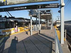
Expo Line train at Culver City Station platform looking east. | ||||||||||||||||||||||||||||||||||||||||||||||||||||||||||||||||||||||||||||||||||||||||||||||||||||||||||||||||||||||||||||||||||||||||||||||||||||||||||||||||||||||||||||||||||||||||||||||||||||||||||||||||||||||||||||||||||||||||||||||||||||||||||||||||||||||||||||||||||||||||||||||||||||||||||||||||||||||||||||||||||||||||||||||||||||||||||||||||||||||||||||||||||||||||||||||||||||||||||||||||||||||||||||||||||||||||||||||||||||||||||||||||||||||||||||||||||||||||||||||||||||||||||||||||||||||||||||||||||||||||||||||||||||||||||||||||||||||||||||||||||||||||||||||||||||||||||||||||||||||||||||||||||||||||||||||||||||||||||||||
| Overview | ||||||||||||||||||||||||||||||||||||||||||||||||||||||||||||||||||||||||||||||||||||||||||||||||||||||||||||||||||||||||||||||||||||||||||||||||||||||||||||||||||||||||||||||||||||||||||||||||||||||||||||||||||||||||||||||||||||||||||||||||||||||||||||||||||||||||||||||||||||||||||||||||||||||||||||||||||||||||||||||||||||||||||||||||||||||||||||||||||||||||||||||||||||||||||||||||||||||||||||||||||||||||||||||||||||||||||||||||||||||||||||||||||||||||||||||||||||||||||||||||||||||||||||||||||||||||||||||||||||||||||||||||||||||||||||||||||||||||||||||||||||||||||||||||||||||||||||||||||||||||||||||||||||||||||||||||||||||||||||||
|---|---|---|---|---|---|---|---|---|---|---|---|---|---|---|---|---|---|---|---|---|---|---|---|---|---|---|---|---|---|---|---|---|---|---|---|---|---|---|---|---|---|---|---|---|---|---|---|---|---|---|---|---|---|---|---|---|---|---|---|---|---|---|---|---|---|---|---|---|---|---|---|---|---|---|---|---|---|---|---|---|---|---|---|---|---|---|---|---|---|---|---|---|---|---|---|---|---|---|---|---|---|---|---|---|---|---|---|---|---|---|---|---|---|---|---|---|---|---|---|---|---|---|---|---|---|---|---|---|---|---|---|---|---|---|---|---|---|---|---|---|---|---|---|---|---|---|---|---|---|---|---|---|---|---|---|---|---|---|---|---|---|---|---|---|---|---|---|---|---|---|---|---|---|---|---|---|---|---|---|---|---|---|---|---|---|---|---|---|---|---|---|---|---|---|---|---|---|---|---|---|---|---|---|---|---|---|---|---|---|---|---|---|---|---|---|---|---|---|---|---|---|---|---|---|---|---|---|---|---|---|---|---|---|---|---|---|---|---|---|---|---|---|---|---|---|---|---|---|---|---|---|---|---|---|---|---|---|---|---|---|---|---|---|---|---|---|---|---|---|---|---|---|---|---|---|---|---|---|---|---|---|---|---|---|---|---|---|---|---|---|---|---|---|---|---|---|---|---|---|---|---|---|---|---|---|---|---|---|---|---|---|---|---|---|---|---|---|---|---|---|---|---|---|---|---|---|---|---|---|---|---|---|---|---|---|---|---|---|---|---|---|---|---|---|---|---|---|---|---|---|---|---|---|---|---|---|---|---|---|---|---|---|---|---|---|---|---|---|---|---|---|---|---|---|---|---|---|---|---|---|---|---|---|---|---|---|---|---|---|---|---|---|---|---|---|---|---|---|---|---|---|---|---|---|---|---|---|---|---|---|---|---|---|---|---|---|---|---|---|---|---|---|---|---|---|---|---|---|---|---|---|---|---|---|---|---|---|---|---|---|---|---|---|---|---|---|---|---|---|---|---|---|---|---|---|---|---|---|---|---|---|---|---|---|---|---|---|---|---|---|---|---|---|---|---|---|---|---|---|---|---|---|---|---|---|---|---|---|---|---|---|---|---|---|---|---|---|---|---|---|---|---|---|---|---|---|---|---|---|---|---|---|---|---|---|---|---|---|---|---|---|---|---|---|---|---|---|---|---|---|---|---|---|---|---|---|---|---|---|---|---|---|---|---|---|---|---|---|---|---|---|---|---|---|---|---|---|---|---|---|---|---|---|---|---|---|---|---|---|---|---|---|---|---|---|---|---|---|---|---|---|---|---|---|---|---|---|---|---|---|---|---|---|---|---|---|---|---|---|---|---|---|---|---|---|---|---|---|---|---|---|---|---|---|---|---|---|---|---|---|---|---|---|---|---|---|---|---|---|---|---|---|---|---|---|---|---|---|
| Owner | Metro Rail | |||||||||||||||||||||||||||||||||||||||||||||||||||||||||||||||||||||||||||||||||||||||||||||||||||||||||||||||||||||||||||||||||||||||||||||||||||||||||||||||||||||||||||||||||||||||||||||||||||||||||||||||||||||||||||||||||||||||||||||||||||||||||||||||||||||||||||||||||||||||||||||||||||||||||||||||||||||||||||||||||||||||||||||||||||||||||||||||||||||||||||||||||||||||||||||||||||||||||||||||||||||||||||||||||||||||||||||||||||||||||||||||||||||||||||||||||||||||||||||||||||||||||||||||||||||||||||||||||||||||||||||||||||||||||||||||||||||||||||||||||||||||||||||||||||||||||||||||||||||||||||||||||||||||||||||||||||||||||||||
| Transit type | Light rail | |||||||||||||||||||||||||||||||||||||||||||||||||||||||||||||||||||||||||||||||||||||||||||||||||||||||||||||||||||||||||||||||||||||||||||||||||||||||||||||||||||||||||||||||||||||||||||||||||||||||||||||||||||||||||||||||||||||||||||||||||||||||||||||||||||||||||||||||||||||||||||||||||||||||||||||||||||||||||||||||||||||||||||||||||||||||||||||||||||||||||||||||||||||||||||||||||||||||||||||||||||||||||||||||||||||||||||||||||||||||||||||||||||||||||||||||||||||||||||||||||||||||||||||||||||||||||||||||||||||||||||||||||||||||||||||||||||||||||||||||||||||||||||||||||||||||||||||||||||||||||||||||||||||||||||||||||||||||||||||
| Line number | 806 | |||||||||||||||||||||||||||||||||||||||||||||||||||||||||||||||||||||||||||||||||||||||||||||||||||||||||||||||||||||||||||||||||||||||||||||||||||||||||||||||||||||||||||||||||||||||||||||||||||||||||||||||||||||||||||||||||||||||||||||||||||||||||||||||||||||||||||||||||||||||||||||||||||||||||||||||||||||||||||||||||||||||||||||||||||||||||||||||||||||||||||||||||||||||||||||||||||||||||||||||||||||||||||||||||||||||||||||||||||||||||||||||||||||||||||||||||||||||||||||||||||||||||||||||||||||||||||||||||||||||||||||||||||||||||||||||||||||||||||||||||||||||||||||||||||||||||||||||||||||||||||||||||||||||||||||||||||||||||||||
| Number of stations | 19 | |||||||||||||||||||||||||||||||||||||||||||||||||||||||||||||||||||||||||||||||||||||||||||||||||||||||||||||||||||||||||||||||||||||||||||||||||||||||||||||||||||||||||||||||||||||||||||||||||||||||||||||||||||||||||||||||||||||||||||||||||||||||||||||||||||||||||||||||||||||||||||||||||||||||||||||||||||||||||||||||||||||||||||||||||||||||||||||||||||||||||||||||||||||||||||||||||||||||||||||||||||||||||||||||||||||||||||||||||||||||||||||||||||||||||||||||||||||||||||||||||||||||||||||||||||||||||||||||||||||||||||||||||||||||||||||||||||||||||||||||||||||||||||||||||||||||||||||||||||||||||||||||||||||||||||||||||||||||||||||
| Daily ridership | 43,199 (July 2016; avg. weekday)[1] | |||||||||||||||||||||||||||||||||||||||||||||||||||||||||||||||||||||||||||||||||||||||||||||||||||||||||||||||||||||||||||||||||||||||||||||||||||||||||||||||||||||||||||||||||||||||||||||||||||||||||||||||||||||||||||||||||||||||||||||||||||||||||||||||||||||||||||||||||||||||||||||||||||||||||||||||||||||||||||||||||||||||||||||||||||||||||||||||||||||||||||||||||||||||||||||||||||||||||||||||||||||||||||||||||||||||||||||||||||||||||||||||||||||||||||||||||||||||||||||||||||||||||||||||||||||||||||||||||||||||||||||||||||||||||||||||||||||||||||||||||||||||||||||||||||||||||||||||||||||||||||||||||||||||||||||||||||||||||||||
| Website |
www | |||||||||||||||||||||||||||||||||||||||||||||||||||||||||||||||||||||||||||||||||||||||||||||||||||||||||||||||||||||||||||||||||||||||||||||||||||||||||||||||||||||||||||||||||||||||||||||||||||||||||||||||||||||||||||||||||||||||||||||||||||||||||||||||||||||||||||||||||||||||||||||||||||||||||||||||||||||||||||||||||||||||||||||||||||||||||||||||||||||||||||||||||||||||||||||||||||||||||||||||||||||||||||||||||||||||||||||||||||||||||||||||||||||||||||||||||||||||||||||||||||||||||||||||||||||||||||||||||||||||||||||||||||||||||||||||||||||||||||||||||||||||||||||||||||||||||||||||||||||||||||||||||||||||||||||||||||||||||||||
| Operation | ||||||||||||||||||||||||||||||||||||||||||||||||||||||||||||||||||||||||||||||||||||||||||||||||||||||||||||||||||||||||||||||||||||||||||||||||||||||||||||||||||||||||||||||||||||||||||||||||||||||||||||||||||||||||||||||||||||||||||||||||||||||||||||||||||||||||||||||||||||||||||||||||||||||||||||||||||||||||||||||||||||||||||||||||||||||||||||||||||||||||||||||||||||||||||||||||||||||||||||||||||||||||||||||||||||||||||||||||||||||||||||||||||||||||||||||||||||||||||||||||||||||||||||||||||||||||||||||||||||||||||||||||||||||||||||||||||||||||||||||||||||||||||||||||||||||||||||||||||||||||||||||||||||||||||||||||||||||||||||||
| Began operation | April 28, 2012[2] | |||||||||||||||||||||||||||||||||||||||||||||||||||||||||||||||||||||||||||||||||||||||||||||||||||||||||||||||||||||||||||||||||||||||||||||||||||||||||||||||||||||||||||||||||||||||||||||||||||||||||||||||||||||||||||||||||||||||||||||||||||||||||||||||||||||||||||||||||||||||||||||||||||||||||||||||||||||||||||||||||||||||||||||||||||||||||||||||||||||||||||||||||||||||||||||||||||||||||||||||||||||||||||||||||||||||||||||||||||||||||||||||||||||||||||||||||||||||||||||||||||||||||||||||||||||||||||||||||||||||||||||||||||||||||||||||||||||||||||||||||||||||||||||||||||||||||||||||||||||||||||||||||||||||||||||||||||||||||||||
| Operator(s) |
| |||||||||||||||||||||||||||||||||||||||||||||||||||||||||||||||||||||||||||||||||||||||||||||||||||||||||||||||||||||||||||||||||||||||||||||||||||||||||||||||||||||||||||||||||||||||||||||||||||||||||||||||||||||||||||||||||||||||||||||||||||||||||||||||||||||||||||||||||||||||||||||||||||||||||||||||||||||||||||||||||||||||||||||||||||||||||||||||||||||||||||||||||||||||||||||||||||||||||||||||||||||||||||||||||||||||||||||||||||||||||||||||||||||||||||||||||||||||||||||||||||||||||||||||||||||||||||||||||||||||||||||||||||||||||||||||||||||||||||||||||||||||||||||||||||||||||||||||||||||||||||||||||||||||||||||||||||||||||||||
| Character | Mostly at-grade in private right-of-way, with some underground, street-running, elevated, and trench sections. | |||||||||||||||||||||||||||||||||||||||||||||||||||||||||||||||||||||||||||||||||||||||||||||||||||||||||||||||||||||||||||||||||||||||||||||||||||||||||||||||||||||||||||||||||||||||||||||||||||||||||||||||||||||||||||||||||||||||||||||||||||||||||||||||||||||||||||||||||||||||||||||||||||||||||||||||||||||||||||||||||||||||||||||||||||||||||||||||||||||||||||||||||||||||||||||||||||||||||||||||||||||||||||||||||||||||||||||||||||||||||||||||||||||||||||||||||||||||||||||||||||||||||||||||||||||||||||||||||||||||||||||||||||||||||||||||||||||||||||||||||||||||||||||||||||||||||||||||||||||||||||||||||||||||||||||||||||||||||||||
| Number of vehicles |
Nippon Sharyo P865, P2020 Siemens P2000 Kinki Sharyo P3010 | |||||||||||||||||||||||||||||||||||||||||||||||||||||||||||||||||||||||||||||||||||||||||||||||||||||||||||||||||||||||||||||||||||||||||||||||||||||||||||||||||||||||||||||||||||||||||||||||||||||||||||||||||||||||||||||||||||||||||||||||||||||||||||||||||||||||||||||||||||||||||||||||||||||||||||||||||||||||||||||||||||||||||||||||||||||||||||||||||||||||||||||||||||||||||||||||||||||||||||||||||||||||||||||||||||||||||||||||||||||||||||||||||||||||||||||||||||||||||||||||||||||||||||||||||||||||||||||||||||||||||||||||||||||||||||||||||||||||||||||||||||||||||||||||||||||||||||||||||||||||||||||||||||||||||||||||||||||||||||||
| Train length | 2–3 vehicles | |||||||||||||||||||||||||||||||||||||||||||||||||||||||||||||||||||||||||||||||||||||||||||||||||||||||||||||||||||||||||||||||||||||||||||||||||||||||||||||||||||||||||||||||||||||||||||||||||||||||||||||||||||||||||||||||||||||||||||||||||||||||||||||||||||||||||||||||||||||||||||||||||||||||||||||||||||||||||||||||||||||||||||||||||||||||||||||||||||||||||||||||||||||||||||||||||||||||||||||||||||||||||||||||||||||||||||||||||||||||||||||||||||||||||||||||||||||||||||||||||||||||||||||||||||||||||||||||||||||||||||||||||||||||||||||||||||||||||||||||||||||||||||||||||||||||||||||||||||||||||||||||||||||||||||||||||||||||||||||
| Technical | ||||||||||||||||||||||||||||||||||||||||||||||||||||||||||||||||||||||||||||||||||||||||||||||||||||||||||||||||||||||||||||||||||||||||||||||||||||||||||||||||||||||||||||||||||||||||||||||||||||||||||||||||||||||||||||||||||||||||||||||||||||||||||||||||||||||||||||||||||||||||||||||||||||||||||||||||||||||||||||||||||||||||||||||||||||||||||||||||||||||||||||||||||||||||||||||||||||||||||||||||||||||||||||||||||||||||||||||||||||||||||||||||||||||||||||||||||||||||||||||||||||||||||||||||||||||||||||||||||||||||||||||||||||||||||||||||||||||||||||||||||||||||||||||||||||||||||||||||||||||||||||||||||||||||||||||||||||||||||||||
| System length | 15.2 mi (24.5 km)[2] | |||||||||||||||||||||||||||||||||||||||||||||||||||||||||||||||||||||||||||||||||||||||||||||||||||||||||||||||||||||||||||||||||||||||||||||||||||||||||||||||||||||||||||||||||||||||||||||||||||||||||||||||||||||||||||||||||||||||||||||||||||||||||||||||||||||||||||||||||||||||||||||||||||||||||||||||||||||||||||||||||||||||||||||||||||||||||||||||||||||||||||||||||||||||||||||||||||||||||||||||||||||||||||||||||||||||||||||||||||||||||||||||||||||||||||||||||||||||||||||||||||||||||||||||||||||||||||||||||||||||||||||||||||||||||||||||||||||||||||||||||||||||||||||||||||||||||||||||||||||||||||||||||||||||||||||||||||||||||||||
| No. of tracks | 2 | |||||||||||||||||||||||||||||||||||||||||||||||||||||||||||||||||||||||||||||||||||||||||||||||||||||||||||||||||||||||||||||||||||||||||||||||||||||||||||||||||||||||||||||||||||||||||||||||||||||||||||||||||||||||||||||||||||||||||||||||||||||||||||||||||||||||||||||||||||||||||||||||||||||||||||||||||||||||||||||||||||||||||||||||||||||||||||||||||||||||||||||||||||||||||||||||||||||||||||||||||||||||||||||||||||||||||||||||||||||||||||||||||||||||||||||||||||||||||||||||||||||||||||||||||||||||||||||||||||||||||||||||||||||||||||||||||||||||||||||||||||||||||||||||||||||||||||||||||||||||||||||||||||||||||||||||||||||||||||||
| Track gauge |
4 ft 8 1⁄2 in (1,435 mm) (standard gauge) | |||||||||||||||||||||||||||||||||||||||||||||||||||||||||||||||||||||||||||||||||||||||||||||||||||||||||||||||||||||||||||||||||||||||||||||||||||||||||||||||||||||||||||||||||||||||||||||||||||||||||||||||||||||||||||||||||||||||||||||||||||||||||||||||||||||||||||||||||||||||||||||||||||||||||||||||||||||||||||||||||||||||||||||||||||||||||||||||||||||||||||||||||||||||||||||||||||||||||||||||||||||||||||||||||||||||||||||||||||||||||||||||||||||||||||||||||||||||||||||||||||||||||||||||||||||||||||||||||||||||||||||||||||||||||||||||||||||||||||||||||||||||||||||||||||||||||||||||||||||||||||||||||||||||||||||||||||||||||||||
| Electrification | 750 V DC overhead catenary | |||||||||||||||||||||||||||||||||||||||||||||||||||||||||||||||||||||||||||||||||||||||||||||||||||||||||||||||||||||||||||||||||||||||||||||||||||||||||||||||||||||||||||||||||||||||||||||||||||||||||||||||||||||||||||||||||||||||||||||||||||||||||||||||||||||||||||||||||||||||||||||||||||||||||||||||||||||||||||||||||||||||||||||||||||||||||||||||||||||||||||||||||||||||||||||||||||||||||||||||||||||||||||||||||||||||||||||||||||||||||||||||||||||||||||||||||||||||||||||||||||||||||||||||||||||||||||||||||||||||||||||||||||||||||||||||||||||||||||||||||||||||||||||||||||||||||||||||||||||||||||||||||||||||||||||||||||||||||||||
| Top speed | 55 mph (89 km/h) | |||||||||||||||||||||||||||||||||||||||||||||||||||||||||||||||||||||||||||||||||||||||||||||||||||||||||||||||||||||||||||||||||||||||||||||||||||||||||||||||||||||||||||||||||||||||||||||||||||||||||||||||||||||||||||||||||||||||||||||||||||||||||||||||||||||||||||||||||||||||||||||||||||||||||||||||||||||||||||||||||||||||||||||||||||||||||||||||||||||||||||||||||||||||||||||||||||||||||||||||||||||||||||||||||||||||||||||||||||||||||||||||||||||||||||||||||||||||||||||||||||||||||||||||||||||||||||||||||||||||||||||||||||||||||||||||||||||||||||||||||||||||||||||||||||||||||||||||||||||||||||||||||||||||||||||||||||||||||||||
| ||||||||||||||||||||||||||||||||||||||||||||||||||||||||||||||||||||||||||||||||||||||||||||||||||||||||||||||||||||||||||||||||||||||||||||||||||||||||||||||||||||||||||||||||||||||||||||||||||||||||||||||||||||||||||||||||||||||||||||||||||||||||||||||||||||||||||||||||||||||||||||||||||||||||||||||||||||||||||||||||||||||||||||||||||||||||||||||||||||||||||||||||||||||||||||||||||||||||||||||||||||||||||||||||||||||||||||||||||||||||||||||||||||||||||||||||||||||||||||||||||||||||||||||||||||||||||||||||||||||||||||||||||||||||||||||||||||||||||||||||||||||||||||||||||||||||||||||||||||||||||||||||||||||||||||||||||||||||||||||
The Expo Line is a light-rail line that runs between Downtown Los Angeles and Santa Monica. The line is named "Expo" after Exposition Boulevard, which it runs alongside for most of its route. It is one of the six lines in the Metro Rail system, and is operated by the Los Angeles County Metropolitan Transportation Authority (Metro).
The Expo Line largely follows the right-of-way of the Santa Monica Air Line, which ceased operation in 1953. Several Expo Line stations are built in the same location as Air Line stations, although no original station structures have been reused.[3]
Service description
_route_map.png)
Construction
An independent agency, the Exposition Metro Line Construction Authority, was given the authority to plan, design, and construct the line by state law in 2003. After construction was completed, the line was handed over on January 15, 2016, to the Los Angeles County Metropolitan Transportation Authority for testing and operation.[4]
The line was built in two phases; the first phase comprised the 8.6-mile (13.8 km)[2][5] section between Downtown Los Angeles and Culver City. Construction began in early 2006 and most stations opened to the public on April 28, 2012.[5] The Culver City and Farmdale stations opened on June 20, 2012.[5][6]
Design and construction on the 6.6-mile (10.6 km)[2] portion between Culver City and Santa Monica started in September 2011. Testing along the phase 2 segment began on April 6, 2015,[7] and the segment opened on May 20, 2016.[8]
Hours of operation
The Expo Line operates from approximately 4:30 a.m. to 2:00 a.m. on weekdays and until 2:30 a.m. on Fridays and Saturdays.[9]
Headways
As of June 2013, trains run approximately every 12 minutes during the daytime, every 10 minutes during the evening, and every 20 minutes after midnight.[9][10][11]
Speed
Maximum speed on the route is 55 mph (89 km/h), though it generally runs much slower than this.[12]
History

Steam railroad
The line was first built in 1875[13] as the steam-powered Los Angeles and Independence Railroad to bring mining ore to ships in Santa Monica harbor and as a passenger excursion train to the beach—first independently and later after purchase by the Southern Pacific Railroad in 1877. When the Santa Monica harbor closed to shipping traffic in 1909 the line was leased to Pacific Electric who converted it to electric traction.
Early electric service
By 1920 the line was called the Santa Monica Air Line[14] providing electric-powered freight and passenger service between Los Angeles and Santa Monica. Electrically-powered passenger service stopped in 1953 but diesel-powered freight deliveries to warehouses along the route continued until March 11, 1988.[15]
Abandonment
While Southern Pacific maintained ownership of the right-of-way after 1988, it no longer used or maintained the rails. Portions of the right-of-way were leased for use as storage facilities, parking lots, impound lots, and various businesses, but no permanent structures were built.
Community rescue
The abandonment of the line spurred concerns within the community to prevent the line from being sold off piecemeal—destroying one of the few remaining intact rail corridors within Los Angeles County. Advocacy groups including Friends 4 Expo Transit[16] supported the successful passage of Proposition C in 1990, which allowed the purchase of the entire right-of-way from Southern Pacific by Metro (LACTC).
Metro successfully lobbied the federal government to use the remainder of Red Line funding for a different project to the Mid-City district of Los Angeles in 1998. That same year Los Angeles County voters approved Proposition A, another sales tax increase for transit, allowing Metro access to additional funds for transit projects. Metro then released a Major Investment Study in 2000 which compared bus rapid transit and light rail transit options along what was now known as the "Mid-City/Exposition Corridor".[17] Construction began in August 2010.[18]
Naming and color
Initially, the Expo Line was planned to be called the "Aqua Line".[19] Plans were shelved in favor of the "Expo Line" designation, though the line retains the aqua color.
Expansion
Metro conducted study on the Expo Phase 2 from 2007 to 2009 and approved the project in 2010, with planned opening to Santa Monica in early 2016. The Expo Construction Authority officially handed over control of the Expo Phase II track to L.A. Metro for the county transit agency to begin pre-revenue train testing on January 15, 2016.[20] This phase was opened on May 20, 2016.[21]
Proposed developments
Regional Connector Transit Corridor
The Regional Connector Transit Corridor (also known as the Regional Connector, Downtown Connector or Downtown Light-Rail Connector) is an under-construction light-rail subway corridor through Downtown Los Angeles that is to connect the current Blue and Expo Lines to the current Gold Line, and to allow a seamless one-seat ride between the Blue and Expo lines' current 7th Street/Metro Center terminus and Union Station.[22]
Once the Regional Connector Transit Corridor is completed, the Eastside leg of the Gold Line will be connected to the Expo Line. At the same time, the northern leg of the Gold Line through the San Gabriel Valley will be joined with the current Blue Line connecting Downtown Los Angeles and Long Beach, creating what will be the longest light-rail transit line in the United States. Names and/or colors for these new lines have not yet been officially announced, but it seems likely that the current Expo Line-eastern leg of the Gold Line will become the new Gold Line, and the Blue Line-northern leg of the Gold Line will become the new Blue Line.[23] Under a proposed system in which each Metro rail and BRT line would be assigned a letter and a color, the current Expo Line and the southern leg of the current Gold Line would be combined into the gold-colored Line E, retaining elements of the identities of both current lines.[24][25] The groundbreaking for the construction of the Regional Connector Transit Corridor took place on September 30, 2014, and the alignment is expected to be in public service by early 2020.[26]
Station listing
The following is the complete list of stations from Downtown Los Angeles traveling west.[27]
| Station | Connections/Notes | Date opened | City/Neighborhood |
|---|---|---|---|
| 7th Street/Metro Center |
|
February 15, 1991 | Downtown Los Angeles |
| Pico |
|
July 14, 1990 | |
| LATTC/Ortho Institute |
|
April 28, 2012 | Los Angeles (North University Park) |
| Jefferson/USC |
| ||
| Expo Park/USC |
|
Los Angeles (Exposition Park) | |
| Expo/Vermont |
| ||
| Expo/Western |
| ||
| Expo/Crenshaw |
|
Los Angeles (Jefferson Park) | |
| Farmdale |
|
June 20, 2012 | Los Angeles (Baldwin Hills) |
| Expo/La Brea |
|
April 28, 2012 | |
| La Cienega/Jefferson |
| ||
| Culver City |
|
June 20, 2012 | Culver City |
| Palms |
|
May 20, 2016 | Los Angeles (Palms) |
| Westwood/Rancho Park |
|
Los Angeles (Rancho Park) | |
| Expo/Sepulveda |
|
Los Angeles (West Los Angeles) | |
| Expo/Bundy |
| ||
| 26th Street/Bergamot |
|
Santa Monica | |
| 17th Street/Santa Monica College |
| ||
| Downtown Santa Monica |
|
Operations
Maintenance facilities
Previously, the light rail vehicles used on the Expo Line were maintained at the division 11 yard in Long Beach, California, the same maintenance facility that is used by the Blue Line. However, the new division 14 yard, located east of Stewart Street and north of Exposition Boulevard[28][29] in the vicinity of the 26th Street/Bergamot station in Santa Monica, was opened with the completion of Phase 2.
Rolling stock
Compatible with the rest of Metro's light-rail network, the Expo Line shares standard Metro light rail vehicles (Nippon Sharyo P865 and P2020, and Siemens P2000) with the Blue Line. Metro estimates that it has 47 light rail cars to provide service on the Expo Line under the peak-hour assumption of 3-car trains running at 6-minute headways.
Upon completion of Phase 2, it is expected that new P3010 light rail vehicles (LRVs) from Kinki Sharyo,[30] that were ordered by the L.A. Metro board of directors in 2012,[31] will begin operation, replacing the current LRVs in operation on the Expo Line.
Bikeway
The Expo Line Bikeway parallels the route of the light rail line, and includes a mixture of bike lanes on Exposition Boulevard and off-street paths alongside the rail tracks.[32]
References
- ↑ "Ridership Statistics". Los Angeles County Metropolitan Transit Authority. Retrieved August 8, 2016.
- 1 2 3 4 "Expo Line project fact sheet" (PDF). Los Angeles County Metropolitan Transportation Authority. 2012. Retrieved October 6, 2013.
- ↑ Hawthorne, Christopher (May 20, 2016). "Why the Expo Line to Santa Monica marks a rare kind of progress in American cities". Los Angeles Times. Retrieved 12 July 2016.
- ↑ "About Expo Overview". BuildExpo. Retrieved May 25, 2015.
- 1 2 3 "L.A. Metro - Facts at a Glance". Los Angeles County Metropolitan Transportation Authority. June 13, 2013. Retrieved June 28, 2013.
- ↑ "Two more Expo Line stations to open June 20". Los Angeles Times. June 5, 2012. Retrieved October 6, 2013.
- ↑ Nunez, Jennifer (April 9, 2015). "Testing begins on LA Expo Line phase 2". International Railway Journal. Retrieved May 25, 2015.
- ↑ Zeller, Heidi (March 30, 2015). "Art for the Expo Line: installation at Expo/Sepulveda Station". The Source. Los Angeles County Metropolitan Transportation Authority. Retrieved March 31, 2015.
- 1 2 "Expo line timetable" (PDF). Los Angeles County Metropolitan Transportation Authority. June 23, 2013. Retrieved April 20, 2014.
- ↑ "Bus and Rail System (map)" (PDF). Los Angeles County Metropolitan Transportation Authority. December 2013. Retrieved April 20, 2014.
- ↑ "Expo Line FAQ". The Source. Los Angeles County Metropolitan Transportation Authority. April 2, 2012. Retrieved October 6, 2013.
- ↑ Hymon, Steve (November 22, 2011). "Our first ride on the Expo Line". The Source. Los Angeles County Metropolitan Transportation Authority. Retrieved March 31, 2015.
- ↑ “First Train of the Los Angeles and Independence Railroad”. Volume 5, Number 20. © Los Angeles Herald, 1875. Newspaper. Los Angeles Herald. October 19, 1875.
- ↑ "Santa Monica Air Line". Electric Railway Historical Association of Southern California.
- ↑ Morgenthaler, Anne (March 14, 1988). "End of the Line: The last train out of SM blows a final whistle". Santa Monica Outlook.
- ↑ "The Expo Line". friends4expo.org. Retrieved September 30, 2016.
- ↑ "Mid City Westside Transit Draft EIS/EIR: 1.0 History, purpose and need" (PDF). Los Angeles County Metropolitan Transportation Authority.
- ↑ Nelson, Laura J. (December 16, 2013). "Residents living near Expo Line stations reduce car use, study shows". Los Angeles Times.
- ↑ Pool, Bob (March 23, 2006). "MTA Squabbles Over Hue-Mongous Decision". The Los Angeles Times. Retrieved June 30, 2016.
- ↑ "Metro Takes Control of Expo Line to Begin Pre-Revenue Service | Santa Monica Next". www.santamonicanext.org. Retrieved January 29, 2016.
- ↑ Hymon, Steve. "17 things to know about the Expo Phase 2 opening". Metro's The Source. LACMTA. Retrieved 25 February 2016.
- ↑ "Regional Connector Transit Corridor (project website)". Los Angeles County Metropolitan Transportation Authority. March 19, 2015. Retrieved March 31, 2015.
- ↑ "Regional Connector Transit Project" (PDF). Metro. April 2014. Retrieved June 3, 2015.
- ↑ "PowerPoint: Metro staff proposal to rename rail and BRT lines". TheSource. Steve Hymon. Retrieved April 7, 2015.
- ↑ "LA Metro Could Switch Rail Line Names From Colors To Letters". Curbed Los Angeles. Curbed Staff. Retrieved April 3, 2015.
- ↑ Hymon, Steve (September 30, 2014). "Ground is broken for Regional Connector project to link Blue, Expo and Gold Lines". The Source. Metro. Retrieved June 3, 2015.
- ↑ "Metro Expo Line Timetable" (PDF). Metro. June 19, 2014. Retrieved June 3, 2015.
- ↑ "Construction Overview". Build Expo. 2013. Retrieved March 31, 2015.
- ↑ Hymon, Steve (March 21, 2012). "Expo Line maintenance facility". The Source. Los Angeles County Metropolitan Transportation Authority. Retrieved March 31, 2015.
- ↑ "Light rail vehicle procurement" (PDF). Los Angeles County Metropolitan Transportation Authority. June 17, 2010. Retrieved September 24, 2013.
- ↑ "Special Board Meeting April 30, 2012 - Subject: Light Rail Vehicle Procurement" (PDF). Los Angeles County Metropolitan Transportation Authority. April 30, 2012. Retrieved April 20, 2014.
- ↑ Kavanagh, Gary (December 2013). "State of Expo Phase II Bikeway Corridor, & the Biggest Remaining Concerns". Santa Monica Next. Retrieved May 25, 2015.
External links
| Wikimedia Commons has media related to LACMTA Expo Line. |
- Los Angeles County Metropolitan Transportation Authority (Metro)
- BuildExpo (Exposition Metro Line Construction Authority)
- Extensive Collection of Construction Photos
- Expo Phase I Construction Drive By on YouTube
- Los Angeles Metro Expo Line - Phase II Tour, Part 1 on YouTube
| Services |
|  | ||||||||||||||||
|---|---|---|---|---|---|---|---|---|---|---|---|---|---|---|---|---|---|---|
| Facilities and stations | ||||||||||||||||||
| Capital projects | ||||||||||||||||||
| Fleet | ||||||||||||||||||
| Other information | ||||||||||||||||||