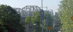
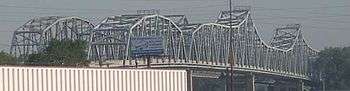
Fairfax Bridge (Missouri River)
| Fairfax Bridge | |
|---|---|
 | |
| Coordinates | 39°09′24″N 94°37′25″W / 39.1566°N 94.6236°WCoordinates: 39°09′24″N 94°37′25″W / 39.1566°N 94.6236°W |
| Carries |
Two lanes of Southbound |
| Crosses | Missouri River |
| Locale | Platte County, Missouri to Kansas City, Kansas |
| Maintained by | MoDOT |
| Characteristics | |
| Design | Truss bridge |
| Total length | 2,486.5 feet |
| History | |
| Opened | September 27, 1934 |
| Closed | October 31, 2014[1] |
The Fairfax Bridge was a truss bridge over the Missouri River that handled southbound U.S. Route 69, connecting Interstate 635 in Riverside, Missouri with the Seventh Street Trafficway in Fairfax, Kansas. Built by the Kansas City Bridge Company, it was 2,486.5 feet long and had 13 spans on 15 piers. The bridge has now been removed, with the approach spans being demolished using explosive charges on January 16, 2015, and the main spans on January 24, 2015.
History
Ground was broken April 21, 1931, with the bridge opening on September 27, 1934 at a cost of $600,000. Originally carrying two-way traffic, it was restriped for two southbound lanes in 1957 following the opening of its sister bridge, the Platte Purchase Bridge, which handles northbound traffic. In 2013 plans were announced for replacement of both the Fairfax Bridge and the Platte Purchase Bridge. The Fairfax Bridge is scheduled for demolition first in early 2015, with the bridge closed to all traffic on October 31, 2014.[1] Traffic will be rerouted to the Platte Purchase Bridge until the first half of the new bridge is done.
External links
See also
| Crossings of the Missouri River | ||||
|---|---|---|---|---|
| ||||