Farranfore railway station
Farranfore | |
|---|---|
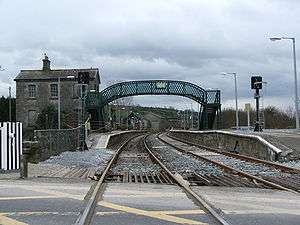
 Railway tracks stretch into the distance towards Killarney from the level crossing at one end of Farranfore station. | |
| Location | Ireland |
| History | |
| Opened | 18 July 1859 |
| Mallow to Tralee | ||||||||||||||||||||||||||||||||||||||||||||||||||||||||||||||||||||||||||||||||||||||||||||||||||||||||||||||||||||||||||||||||||||||
|---|---|---|---|---|---|---|---|---|---|---|---|---|---|---|---|---|---|---|---|---|---|---|---|---|---|---|---|---|---|---|---|---|---|---|---|---|---|---|---|---|---|---|---|---|---|---|---|---|---|---|---|---|---|---|---|---|---|---|---|---|---|---|---|---|---|---|---|---|---|---|---|---|---|---|---|---|---|---|---|---|---|---|---|---|---|---|---|---|---|---|---|---|---|---|---|---|---|---|---|---|---|---|---|---|---|---|---|---|---|---|---|---|---|---|---|---|---|---|---|---|---|---|---|---|---|---|---|---|---|---|---|---|---|---|
Legend | ||||||||||||||||||||||||||||||||||||||||||||||||||||||||||||||||||||||||||||||||||||||||||||||||||||||||||||||||||||||||||||||||||||||
| ||||||||||||||||||||||||||||||||||||||||||||||||||||||||||||||||||||||||||||||||||||||||||||||||||||||||||||||||||||||||||||||||||||||
Farranfore railway station serves the village of Farranfore in County Kerry. It is the only railway station in Ireland that connects with an airport, in this case Kerry Airport, which is located 1.3 kilometres (0.81 mi) to the north. As of late 2010, there are no signs at the station promoting the footpath link to the airport.
History
Farranfore was formerly the junction station for the branch line to Valentia Harbour - once the most westerly station in Ireland. This line closed in 1960.
The station opened on 18 July 1859.[1]
See also
External links
| Preceding station | Following station | |||
|---|---|---|---|---|
| Killarney | InterCity Dublin-Tralee |
Tralee Casement | ||
| InterCity Cork-Tralee |
||||
| Commuter Mallow-Tralee |
||||
| Historical railways | ||||
| Ballybrack | Tralee and Killarney Railway Tralee Junction-Tralee |
Gortatlea | ||
| Terminus | Great Southern and Western Railway Farranfore-Valentia Harbour |
Molahiffe | ||
References
- ↑ "Farranfore station" (PDF). Railscot - Irish Railways. Retrieved 2007-09-04.
Coordinates: 52°10′25″N 9°33′07″W / 52.17370°N 9.552043°W
This article is issued from Wikipedia - version of the 7/30/2016. The text is available under the Creative Commons Attribution/Share Alike but additional terms may apply for the media files.