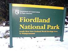
Fiordland National Park
| Fiordland National Park | |
|---|---|
|
IUCN category II (national park) | |
 New Zealand with Fiordland National Park in green | |
| Location | Southland, New Zealand |
| Nearest city | Te Anau, New Zealand |
| Coordinates | 45°25′S 167°43′E / 45.417°S 167.717°ECoordinates: 45°25′S 167°43′E / 45.417°S 167.717°E |
| Area | 12,500 km2 |
| Established | 1952 |
| Governing body | Department of Conservation |
Fiordland National Park occupies the southwest corner of the South Island of New Zealand. It is the largest of the 14 national parks in New Zealand, with an area of 12,500 km2, and a major part of the Te Wahipounamu World Heritage site. The park is administered by the Department of Conservation.
Geographical features
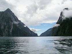
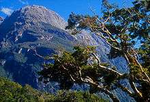

During the cooler past, glaciers carved many deep fiords, the most famous (and most visited) of which is Milford Sound. Other notable fiords include Doubtful Sound and Dusky Sound. From one of the peaks within Fiordland National Park, a view of Mount Aspiring/Tititea to the far north can be observed.[1]
Fiordland's coast is steep and crenellated, with the fiords running from the valleys of the southern ranges of the Southern Alps, such as the Kepler and Murchison Mountains. At the northern end of the park, several peaks rise to over 2,000 metres.
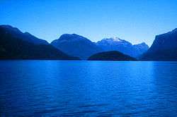
Ice has carved islands from the mainland, leaving two large uninhabited offshore islands, Secretary Island and Resolution Island. Several large lakes lie wholly or partly within the park's boundaries, notably Lake Te Anau, Lake Manapouri, Lake Monowai, Lake Hauroko, and Lake Poteriteri. The Sutherland Falls, to the southwest of Milford Sound on the Milford Track, are among the world's highest waterfalls.
Prevailing westerly winds blow moist air from the Tasman Sea onto the mountains; the cooling of this air as it rises produces a prodigious amount of rainfall, exceeding seven metres in many parts of the park. This supports the lush temperate rain forests of the Fiordland temperate forests ecoregion.
Vegetation and wildlife
The wildlife in this area include dolphins, seals and birds. Introduced species include mice, rats, hare and deer. Among the birds are the kakapo, the only flightless parrot in the world. Also there is the kiwi, which is native to New Zealand. The park is heavily forested with Nothofagus trees, a large variety of understory shrubs and ferns being present; examples of the forest floor vegetation include crown fern, Blechnum discolor.[2]
Public access
Road access to Fiordland is restricted to the Milford Road (SH 94), which runs north from Te Anau, skirting the edge of the park before entering it close to the headwaters of the Eglinton River. From there it crosses the northwest corner of the park, reaching its terminus at Milford Sound. South of Te Anau a smaller road links to Manapouri. A minor road links Doubtful Sound with the western edge of Lake Manapouri via the Wilmot Pass.
Light aircraft and helicopter services link with Milford Sound, which also has a small boat marina.
Parts of Fiordland National Park are a designated Wilderness Area and aircraft landings are not permitted.
Activities
The park is a popular destination for alpine climbers and especially for trampers, with the Milford, Kepler, Hollyford and Routeburn Tracks all in or close to the park.
Fiordland is a challenging tramping destination. There are few tracks. Off-track travel often relies on following deer trails. Sandflies, flooding and poor weather are a hazard.
Other tourists are attracted to areas such as Milford Sound.
Helicopter hunting
Red deer were introduced to New Zealand in the 1850s and they subsequently colonised the Fiordland Park area.{Banwell, D. 2001} By the 1920s, the large herds of wild deer in the NZ back country competing with sheep and cattle for feed resulted in pressure on the NZ government from the farming community, and deer cullers were employed by the Internal Affairs department to indiscriminately shoot deer in an effort to reduce the population. Costs were recouped from the sale of deer hides.
During the early 1960s, an international market for wild venison was established, and with no restrictions on hunting, market hunters established themselves in the rugged park country and used pack horses, jetboats and fixed wing aircraft to get the carcasses out to market. Experiments with shooting wild deer from helicopters were highly successful and a competitive industry was based on this technique. By the late 1970s, the deer population in Fiordland had been severely reduced, and combined with a flourishing deer farming industry this has reduced the impact of aerial hunting over the national park.
Market hunting from helicopters continues today in a reduced fashion, with the largest market being Germany. The NZ government uses helicopters to poison the deer and possum population with aerial dropping of large volumes of 1080 poison, despite some public opposition to the use of such poisons.
See also
- National parks of New Zealand
- Forest parks of New Zealand
- Regional parks of New Zealand
- Protected areas of New Zealand
- Conservation in New Zealand
- Department of Conservation
References
- C. Michael Hogan. 2009. Crown Fern: Blechnum discolor, Globaltwitcher.com, ed. N. Stromberg
- New Zealand Department of Tourist and Publicity. 1906. New Zealand Lakes and Fiords,the Wonders of Western Otago: Descriptive of the Southern Lakes and Mountains,the West Coast Sounds and Stewart Island, published by J.Mackay
Line notes
External links
| Wikivoyage has a travel guide for Fiordland National Park. |
| Wikimedia Commons has media related to Fiordland National Park. |
- Fiordland National Park, Department of Conservation
- Fiordland Coastal Newsletter