Fisher Nunatak
Not to be confused with Fischer Nunatak.
Location of Sentinel Range in Western Antarctica.

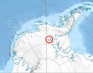
Northern Sentinel Range map.
Fisher Nunatak is a nunatak with rock exposure, standing 13 nautical miles (24 km) west of Mount Crawford of the Sentinel Range, in the Ellsworth Mountains of Antarctica. It was discovered by the Marie Byrd Land Traverse party, 1957–58, under C.R. Bentley, and was named for Diana D. Fisher, director, Glaciological Headquarters, of the United States – International Geophysical Year Program, 1956–59.[1]
References
- ↑ "Fisher Nunatak". Geographic Names Information System. United States Geological Survey. Retrieved 2012-03-24.
![]() This article incorporates public domain material from the United States Geological Survey document "Fisher Nunatak" (content from the Geographic Names Information System).
This article incorporates public domain material from the United States Geological Survey document "Fisher Nunatak" (content from the Geographic Names Information System).
Coordinates: 77°43′S 87°27′W / 77.717°S 87.450°W
This article is issued from Wikipedia - version of the 11/21/2015. The text is available under the Creative Commons Attribution/Share Alike but additional terms may apply for the media files.