Flåvær Lighthouse
 Flåvær lighthouse | |
 Møre og Romsda | |
| Location |
Flåvær Herøy Norway |
|---|---|
| Coordinates | 62°18′56″N 5°34′56″E / 62.315664°N 5.582167°ECoordinates: 62°18′56″N 5°34′56″E / 62.315664°N 5.582167°E |
| Year first constructed | 1870 |
| Automated | 1979 |
| Foundation | granite basement |
| Construction | wooden tower |
| Tower shape | square parallelepiped tower with balcony and lantern |
| Markings / pattern | white tower, red balcony and lantern |
| Height | 13.8 m (45 ft) |
| Current lens | 4th order Fresnel lens |
| Range | 13.2 nmi (24.4 km; 15.2 mi) |
| Characteristic | Oc (3) WRG 10s. |
| Admiralty number | L0674 |
| NGA number | 5800 |
| ARLHS number | NOR-085 |
| Norway number | NF-3125 |
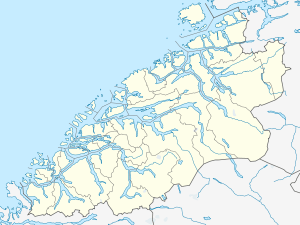
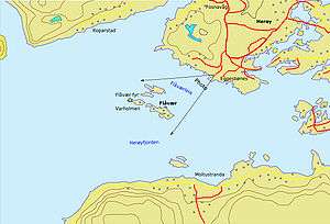
Flåvær fyr is a coastal lighthouse on the island of Vardholmen in the Flåvær islands in the Herøyfjord in the municipality of Herøy on west coast of Norway. The lighthouse is located southwest of Fosnavåg and Eggesbønes and north of the island of Gurskøya.
The 13.8-metre (45 ft) tall lighthouse was first built in 1870, and it was renovated in 1887 and 1914. In 1952 it was connected to the electrical power grid, and it was fully automated in 1979.

Map of Flåvær lighthouse in the Herøyfjord.
See also
References
- Ryvarden, Leif; Lauritzen, Per Roger (2006). KystNorge. 1–3. Oslo: Gyldendal. ISBN 978-82-05-35265-0.
- Rowlett, Russ. "Lighthouses of Norway: Ålesund Area". The Lighthouse Directory. University of North Carolina at Chapel Hill.
External links
This article is issued from Wikipedia - version of the 4/16/2016. The text is available under the Creative Commons Attribution/Share Alike but additional terms may apply for the media files.