Flacq District
| Flacq | |
|---|---|
| District | |
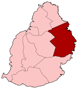 Map of Mauritius island with Flacq District highlighted | |
| Country |
|
| Government | |
| Area | |
| • Total | 297.9 km2 (115.0 sq mi) |
| Population (2012)[1] | |
| • Total | 141,586 |
| • Rank | 2nd in Mauritius |
| • Density | 480/km2 (1,200/sq mi) |
| Time zone | MUT (UTC+4) |
| ISO 3166 code | MU-FL (Flacq) |
Flacq is a district of Mauritius, situated in the east of the island. It is the largest district, having an area of 297.9 km², the population estimate was at 141,586 as at 31 December 2012.[1]
Places of interest
The small village of Trou d'Eau Douce, from where visitors take boats for tours on Île aux Cerfs island. Belle Mare, an exotic beach with white sand and nice lagoon, attracts a lot of Mauritians and tourists.
Places
The Flacq District include different regions; however, some regions are further divided into different suburbs.[1] Note that the statistics do not take into account the two new village councils areas were created out of Écroignard and Grande Retraite out of Laventure in 2011 following the new Local Government Act.[2]
Places by population
| Places by population, area and density | ||||||||
|---|---|---|---|---|---|---|---|---|
| Place | Population[3] | Area in km²[4] | Population density per km²[4] | |||||
| Bel Air Rivière Sèche | 27,605 | 18.15 | 970 | |||||
| Centre de Flacq | 15,791 | 20.27 | 779 | |||||
| Lallmatie (West in Moka district) | 10,387 | 8.92 | 1,164.5 | |||||
| Bon Accueil | 6,203 | 4.38 | 1,416.2 | |||||
| Brisée Verdière (North in Rivière du Rempart district) | 7,512 | 15.58 | 482.2 | |||||
| Camp de Masque Pavé | 4,260 | 10.38 | 410.4 | |||||
| Camp de Masque | 2,720 | 2.87 | 947.7 | |||||
| Camp Ithier | 4,269 | 5.52 | 773.4 | |||||
| Clémencia | 1,825 | 16.04 | 113.8 | |||||
| Écroignard | 6,189 | 3.81 | 1,624.4 | |||||
| Grand River South-East | 2,107 | 9.26 | 227.5 | |||||
| Laventure | 5,995 | 14.39 | 416.6 | |||||
| Mare La Chaux | 1,925 | 1.53 | 1,258.2 | |||||
| Médine Camp de Masque (West in Moka district) | 7,116 | 9.27 | 767.6 | |||||
| Olivia, Mauritius | 3,667 | 24.58 | 149.2 | |||||
| Poste de Flacq | 8,454 | 28.32 | 298.5 | |||||
| Quatre Cocos | 5,872 | 15.21 | 386.1 | |||||
| Quatre Soeurs | 3,317 | 5.01 | 662.1 | |||||
| Queen Victoria | 2,898 | 20.69 | 140.1 | |||||
| Sébastopol | 5,553 | 25.34 | 219.1 | |||||
| St Julien (Haut de Flacq) (West in Moka district) | 2,676 | 16.98 | 157.6 | |||||
| St Julien D'Hotman (West in Moka district) | 3,361 | 7.17 | 468.8 | |||||
| Trou D'Eau Douce | 5,672 | 11.08 | 511.9 | |||||
See also
| Wikimedia Commons has media related to Flacq District. |
References
- 1 2 3 Ministry of Finance & Economic Development (2012). "ANNUAL DIGEST OF STATISTICS 2012" (PDF). 31 December. Government of Mauritius: 22. Retrieved 20 October 2013.
- ↑ http://www.lemauricien.com/article/municipales-toilettage-des-registres-d%E2%80%99%C3%A9lecteurs
- ↑ "2011 housing and population census" (PDF). Statistics Mauritius. p. 51. Archived from the original (PDF) on 16 October 2013.
- 1 2 http://www.gov.mu/portal/goc/cso/report2013/migra2012.pdf
 |
Pamplemousses | Rivière du Rempart | | |
| Moka | |
Indian Ocean | ||
| ||||
| | ||||
| Grand Port |
Coordinates: 20°14′S 57°43′E / 20.233°S 57.717°E
Belle Mare Geography, attractions & facilities