Flaming Mountains
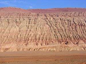
The Flaming Mountains (Chinese: 火焰山; pinyin: huǒyànshān) or Gaochang Mountains are barren, eroded, red sandstone hills in Tian Shan Mountain range, Xinjiang, China. They lie near the northern rim of the Taklamakan Desert and east of the city of Turpan. Their striking gullies and trenches caused by erosion of the red sandstone bedrock give the mountains a flaming appearance at certain times of the day.
The mountains are approximately 100 kilometres (60 mi) long and 5–10 km (3–6 mi) wide, crossing the Turpan Depression from east to west. The average height of the Flaming Mountains is 500 m (1,600 ft), with some peaks reaching over 800 m (2,600 ft). The mountain climate is harsh, and the extremely high summer temperatures make this the hottest spot in China, frequently reaching 50 °C (122 °F) or higher. One of the largest thermometers in China—a popular tourist spot—is on display adjacent to the mountain, tracking the surrounding air temperature.
A number of important palaeontological remains have been found in the area, see e.g. Lianmuqin Formation and Subashi Formation.
Silk route


In ancient times, the merchant traders traversing the Silk Route in southeast Asia avoided the mountains by stopping at oasis towns, such as Gaochang, built on the desert's rim at the foot of the Flaming Mountains and near an important mountain pass. Oasis towns became respite stops for traveling merchant traders. Buddhist missionaries often accompanied traders on busy international trade routes. During this time trade boomed on the Silk Route. Buddhist monasteries and temples were built in the busy trading centers and in nearby remote mountain spots.[1][2]
The Bezeklik Thousand Buddha Caves site lies in a gorge under the cliffs of the Flaming Mountains near the pass by Gaochang. It is a complex of seventy Buddhist cave grottoes dating from the 5th to the 9th centuries CE, many with thousands of murals of Buddha.[3][4]
Literary fame
The Flaming Mountains received their name from a fantasy account of a Buddhist monk, accompanied by a Monkey King with magical powers. The monk runs into a wall of flames on his pilgrimage to India in the popular 16th century novel, Journey to the West, by Ming Dynasty writer, Wu Cheng'en.[5] The novel is an embellished description of the monk Xuanzang who traveled to India in 627 CE to obtain Buddhist scriptures and went through a pass in the Tien Shan after leaving Gaochang.[6]
Mythology
According to the classical novel Journey to the West, the Monkey King created a disturbance in the heavens and knocked over a kiln, causing embers to fall from the sky to the place where the Flaming Mountains are now. In a Uigur legend, a dragon lived in the Tianshan Mountains. Because the dragon ate little children, a Uigur hero slew the dragon and cut it into eight pieces. The dragon's blood turned into a scarlet mountain of blood and the eight pieces became the eight valleys in the Flaming Mountains.[7]
Climate
A temperature of 152.2 °F (66.8 °C) was measured in 2008.[8]
Footnotes
- ↑ Keay, John (2000). India: A History. New York: Grove Press. pp. 103, 124–27. ISBN 0-8021-3797-0.
- ↑ Ebrey, Patricia (2006). The Cambridge Illustrated History of China. Cambridge University Press. pp. 106–7, 202. ISBN 0-521-43519-6.
- ↑ "Bizaklik Thousand Buddha Caves". showcaves.com. Retrieved 2007-09-19.
- ↑ "Bizaklik Thousand Buddha Caves". travelchinaguide. Retrieved 2007-09-19.
- ↑ Ebrey, Patricia (2006). The Cambridge Illustrated History of China. Cambridge University Press. p. 202. ISBN 0-521-43519-6.
- ↑ "The Third Cross-Strait Conference — Post-conference Tour to the Flaming Mountains". University of Massachusetts.edu. Retrieved 2007-09-18.
- ↑ "The Flaming Mountains (Huo Yan Shan)". travelchinaguide.com. Retrieved 2007-09-21.
- ↑ "Satellite Finds Highest Land Skin Temperatures on Earth". Bulletin of the American Meteorological Society. 92: 855–860. July 2011. doi:10.1175/2011BAMS3067.1. Retrieved 20 October 2014.
External links
| Wikimedia Commons has media related to Flaming mountains. |
- Photo of the Flaming Mountains
- Xinjiang
- Gaochang
- Xinjiang is home to 47 ethnic groups
- Xinjiang Guide
- The Bezeklik Grottoes in the Flaming Mountains near Turpan - Photo
Coordinates: 42°53′N 89°38′E / 42.883°N 89.633°E