Flatkvål
| Flatkvål Flatekvål | |
|---|---|
| Village | |
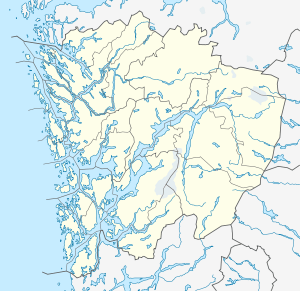 Flatkvål  Flatkvål Location in Hordaland county | |
| Coordinates: 60°47′07″N 05°57′30″E / 60.78528°N 5.95833°ECoordinates: 60°47′07″N 05°57′30″E / 60.78528°N 5.95833°E | |
| Country | Norway |
| Region | Western Norway |
| County | Hordaland |
| District | Nordhordland |
| Municipality | Vaksdal |
| Elevation[1] | 285 m (935 ft) |
| Time zone | CET (UTC+01:00) |
| • Summer (DST) | CEST (UTC+02:00) |
| Post Code | 5728 Eidslandet |
Flatkvål /fla:kol/ is a village in the Eksingedalen valley in Vaksdal municipality, Hordaland county, Norway. The village lies along the river Storelvi, about 30 kilometres (19 mi) northeast of the village of Stamneshella. The Modalen Tunnel is located about 5 kilometres (3.1 mi) west of Flatkvål. The village of Nesheim lies about 15 kilometres (9.3 mi) to the east. Flatkvål is the site of Eksingedal Church.
History
Flatkvål was administratively a part of Voss municipality starting in 1838. On 1 January 1885 the northeastern half of the Eksingedalen valley was separated from Voss to form the new municipality of Evanger (this included Flatkvål). On 1 January 1964, all of the Bergsdalen and Eksingedalen valleys with 251 inhabitants combined were merged with most of Bruvik municipality and a part of Modalen municipality to create the new municipality Vaksdal. Flatkvål has been part of Vaksdal since that time.[2]
Media gallery
-
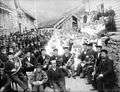
The people of the Eksingedalen valley celebrating that parts of the new road through the valley have been completed. The celebrations took place at Flatekval, ca. 1890.
-
.jpg)
A group photo at another road-opening celebration in Flatekval in 1897.
References
- ↑ "Flatkvål" (in Norwegian). yr.no. Retrieved 2014-05-03.
- ↑ Jukvam, Dag (1999). "Historisk oversikt over endringer i kommune- og fylkesinndelingen" (PDF) (in Norwegian). Statistisk sentralbyrå.