Flint Run (West Virginia)
| Flint Run | |
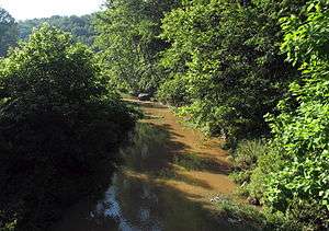 Flint Run near its confluence with McElroy Creek | |
| Country | United States |
|---|---|
| State | West Virginia |
| Counties | Doddridge, Tyler |
| Source | |
| - location | east of Doak |
| - elevation | 1,165 ft (355 m) [1] |
| - coordinates | 39°18′48″N 80°35′55″W / 39.3134196°N 80.598709°W [2] |
| Mouth | McElroy Creek |
| - location | east of Little Pittsburg |
| - elevation | 735 ft (224 m) [2] |
| - coordinates | 39°23′43″N 80°43′59″W / 39.3953603°N 80.7331584°WCoordinates: 39°23′43″N 80°43′59″W / 39.3953603°N 80.7331584°W [2] |
| Length | 7.5 mi (12 km) |
| Basin | 25.6 sq mi (66 km2) |
| Hydrologic Unit Code | 050302010302 (USGS) |
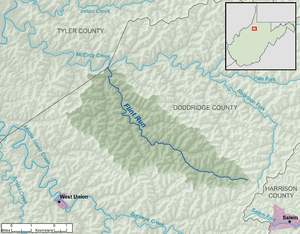 A map of Flint Run and its watershed | |
Flint Run is a tributary of McElroy Creek, 7.5 miles (12.1 km) long,[3] in northern West Virginia in the United States. Via McElroy Creek, Middle Island Creek, and the Ohio River, it is part of the watershed of the Mississippi River, draining an area of 25.6 square miles (66 km2)[4] in a rural region on the unglaciated portion of the Allegheny Plateau.
Flint Run rises in Doddridge County near its boundary with Harrison County, approximately 1.9 miles (3.1 km) east of the unincorporated community of Doak, and flows generally northwestward through northern Doddridge County, through Doak and the unincorporated community of Flint. It flows into McElroy Creek from the south on the boundary of Doddridge and Tyler counties, approximately 0.5 miles (0.80 km) east of Little Pittsburg.[5][6]
According to the Geographic Names Information System, the stream has also been known historically by the name "Big Flint Run."[2] It collects a tributary named Little Flint Run[7] a short distance upstream of its mouth.[5][6]
See also
References
- ↑ The National Map elevation for GNIS source coordinates. Retrieved 2013-07-17.
- 1 2 3 4 Geographic Names Information System. "Geographic Names Information System entry for Flint Run (Feature ID #1539093)". Retrieved 2013-07-18.
- ↑ United States Environmental Protection Agency. "West Virginia, Little Muskingum-Middle Island Watershed". Archived from the original on 2011-10-15. Retrieved 2013-07-18.
- ↑ U.S. Geological Survey. National Hydrography Dataset. Area data for Flint Run watershed, 12-digit Hydrologic Unit Code 050302010302. The National Map, retrieved 2013-07-18
- 1 2 The National Map, accessed 2013-07-18
- 1 2 West Virginia Atlas & Gazetteer. Yarmouth, Me.: DeLorme. 1997. p. 24. ISBN 0-89933-246-3.
- ↑ Geographic Names Information System. "Geographic Names Information System entry for Little Flint Run (Feature ID #1542101)". Retrieved 2013-07-18.