Ford, Wiltshire
This article is about the village near Chippenham, Wiltshire. For the village near Salisbury, see Laverstock and Ford.

Coordinates: 51°28′19″N 2°13′48″W / 51.472°N 2.230°W
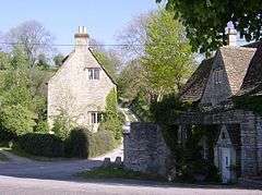
Ford is a small village located in the northwest of Wiltshire, England. It had a population of 580 in the 2001 census. The village is situated along the A420 road, 11 miles east of Bristol and 4 miles west of Chippenham.
Ford is the second largest village in the civil parish of North Wraxall,[1] a collection of five settlements which includes Upper Wraxall, North Wraxall, The Shoe (also on the A420) and Mountain Bower. There is a pub called the White Hart, but no other shops.
The Bybrook River flows through the village.
A church of St John was designed by C.E. Ponting in 1896 and converted into a residence in 2001.[2]
References
- ↑ "Wiltshire Community History". Wiltshire Council. Retrieved 8 March 2013.
- ↑ "Church of St. John, Ford, North Wraxall". Wiltshire Community History. Wiltshire Council. Retrieved 19 March 2015.
External links
![]() Media related to Ford, Wiltshire at Wikimedia Commons
Media related to Ford, Wiltshire at Wikimedia Commons
This article is issued from Wikipedia - version of the 3/19/2015. The text is available under the Creative Commons Attribution/Share Alike but additional terms may apply for the media files.