Forest cover by state in the United States
Forest cover by state is estimated from tree-attributes using the basic statistics reported by the Forest Inventory and Analysis (FIA) Program of the U.S. Department of Agriculture Forest Service (FIA). Tree volumes and weights are not directly measured in the field, but computed from other variables that can be measured.[1][2]
This is only the total amount of timberland, the actual forest cover for each state may be significantly higher.[3][4]
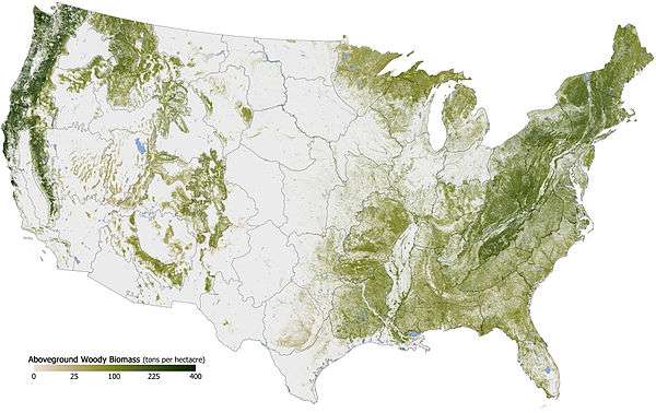
Map of above ground woody biomass across the United States. Source: US Dept. of Agriculture[5]
- Maine 85.8%
- New Hampshire 78.4%
- West Virginia: 77.2%
- Vermont: 75.7%
- Alabama: 70.6%
- Georgia: 64.2%
- South Carolina: 63.8%
- Mississippi: 61.9%
- Virginia: 60.7%
- North Carolina: 59.9%
- Pennsylvania: 55.3%
- Arkansas: 55.1%
- Connecticut: 54.7%
- Tennessee: 52.9%
- Massachusetts: 52.5%
- Michigan: 51.2%
- New York: 50.9%
- Rhode Island: 50.8%
- Louisiana: 49.2%
- Kentucky: 48.6%
- Wisconsin: 45.2%
- Florida: 42.4%
- Washington: 40.7%
- New Jersey: 39.5%
- Oregon: 38.8%
- Maryland: 37.9%
- Idaho: 31.8%
- Alaska: 30.4%
- Missouri: 30.3%
- Delaware: 30.0%
- Minnesota: 28.9%
- Ohio: 28.9%
- Montana: 20.6%
- Indiana: 18.9%
- California: 17.8%
- Colorado: 17.5%
- Hawaii: 17.0%
- Oklahoma: 14.2%
- Illinois: 11.5%
- Wyoming: 9.2%
- Utah: 8.9%
- Texas: 7.0%
- New Mexico: 5.6%
- Iowa: 5.4%
- Arizona: 4.8%
- South Dakota: 3.1%
- Kansas: 2.8%
- Nebraska: 1.8%
- North Dakota: 1.0%
- Nevada: 0.5%
See also
- Forest cover by province or territory in Canada
- Forest cover by state or territory in Australia
- Forest cover by state in India
References
- ↑ FIA Volume Calculations
- ↑ Bechtold, William A.; Patterson, Paul L.; [Editors] 2005. The enhanced forest inventory and analysis program - national sampling design and estimation procedures. Gen. Tech. Rep. SRS-80. Asheville, NC: U.S. Department of Agriculture, Forest Service, Southern Research Station. 85 p.
- ↑ Archived January 7, 2009, at the Wayback Machine.
- ↑ US Forest Service Inventory
- ↑ http://www.fia.fs.fed.us/library/maps/index.php
Further reading
This article is issued from Wikipedia - version of the 11/17/2016. The text is available under the Creative Commons Attribution/Share Alike but additional terms may apply for the media files.