Fort Dundas
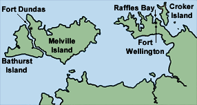
Fort Dundas was a short lived British settlement on Melville Island between 1824 and 1828 in what is now the Northern Territory of Australia. The establishment of the settlement caused the border of New South Wales to be moved west from the 135th meridian to the Western Australian border (129th meridian). The settlement of Fort Dundas was begun in September 1824, after HMS Tamar, HMS Lady Nelson, and Countess of Harcourt had set out from Sydney to colonise the northern part of Australia. Port Dundas was named for Robert Dundas, the First Lord of the Admiralty.
The intention was to commence and develop trade with the Malays. During the first two and a half years, the settlers had never seen a Malay. Furthermore, the settlers had not been able to penetrate more than 20 miles into the island's interior 'due to the hostility of the natives - being in the most savage state of barbarism, and all attempts to concilliate them proving abortive'; such was the report to the British people.[1]
Such bad relations with the Tiwi aborigines (two men were speared), tropical storms, being a large distance from other settlements, and a low food supply made the efforts at settlement especially difficult to the point of complete failure. The British abandoned the effort at the fort in 1828, with the last of the settlers leaving in February 1829. In recent years, archaeologists have excavated parts of the site at present-day Pularumpi.
References
- ↑ The Times, London, article CS118772953 dated 25 June 1827; retrieved 4 May 2004.
See also
- Dundas Island, in British Columbia, Canada, named after Henry Dundas, Robert Dundas' father
External links
- The British Arrive and Leave, Fort Dundas, Melville Island 1824-1829
- Northern Territory History. Early Settlements
- John Morris, The Tiwi and the British: an ill-fated outpost
Coordinates: 11°24′18″S 130°25′02″E / 11.40500°S 130.41722°E