Fort Niagara Light
 Old Fort Niagara Lighthouse | |
 | |
| Location | Old Fort Niagara on Lake Ontario |
|---|---|
| Coordinates | 43°15′42″N 79°3′48″W / 43.26167°N 79.06333°WCoordinates: 43°15′42″N 79°3′48″W / 43.26167°N 79.06333°W |
| Year first constructed | 1872 |
| Year first lit | 1872 |
| Deactivated | 1993 |
| Foundation | Natural/emplaced |
| Construction | Limestone, brick lining |
| Tower shape | Frustum of an octagon |
| Markings / pattern | Natural with black lantern |
| Height | 61 feet (19 m) |
| Focal height | 91 feet (28 m) |
| Original lens | Fourth-order fresnel lens |
| Range | 10 nautical miles (19 km; 12 mi) |
| ARLHS number | USA-294 [1] |
| USCG number | 7-2485 [2] |
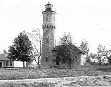
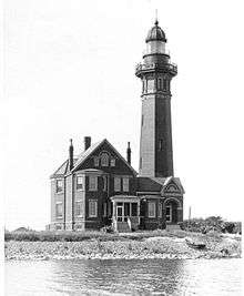
Fort Niagara Light is an inactive lighthouse on the Niagara River on the south shore of Lake Ontario in New York state. It is located on the grounds of Fort Niagara.
History
The lighthouse was established in 1782 atop the "French Castle", a structure still located within Old Fort Niagara. The current tower was first lit in 1872, having been removed from the French Castle to allow for more room for officer's quarters. The light was deactivated in 1996, having been replaced by a light beacon at the US Coast Guard Station Niagara.
The foundation was natural/emplaced and the lighthouse was constructed out of limestone with a brick lining. The tower is octagonal in shape with a black lantern. The original lens was a fourth order Fresnel lens installed in 1859
National Register Status: LISTED; Reference #84002809 Name of Listing: FORT NIAGARA LIGHT (U.S. COAST GUARD/GREAT LAKES TR)
Part of Old Fort Niagara National Historic Landmark; First two towers constructed on the fort; Third (current) tower constructed south of fort; Tower replaced by modern beacon in order to save trees obstructing lantern in 1993.
Cultural
The Archives Center at the Smithsonian National Museum of American History has a collection (#1055) of souvenir postcards of lighthouses and has digitized 272 of these and made them available online. These include postcards of Fort Niagara Light [3] with links to customized nautical charts provided by National Oceanographic and Atmospheric Administration.
See also
References
- ↑ "Fort Niagara (Lake Ontario) Light - ARLHS USA-294". Retrieved 31 July 2016.
- ↑ Light List, Volume VII, Great Lakes (PDF). Light List. United States Coast Guard.
- ↑ Smithsonian lighthouse postcards
Further reading
- Oleszewski, Wes. Great Lakes Lighthouses, American and Canadian: A Comprehensive Directory/Guide to Great Lakes Lighthouses, (Gwinn, Michigan: Avery Color Studios, Inc., 1998) ISBN 0-932212-98-0.
- Scott T. Price. "U. S. Coast Guard Aids to Navigation: A Historical Bibliography". United States Coast Guard Historian's Office.
- U.S. Coast Guard. Historically Famous Lighthouses (Washington, D.C.: Government Printing Office, 1957).
- Wright, Larry and Wright, Patricia. Great Lakes Lighthouses Encyclopedia Hardback (Erin: Boston Mills Press, 2006) ISBN 1-55046-399-3
External links
- Coast Guard list of Lighthouses
- Coast Guard list of assets
- National Park Service's Maritime Heritage Program's Inventory of Historic Light Stations
- National Park Service's Maritime Heritage Program's Inventory of NY Historic Light Stations
- NPS Fort Niagara
| New York, U.S. |
|  |
|---|---|---|
| Ontario, Canada |
| |