Maryland Route 173
| ||||
|---|---|---|---|---|
|
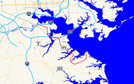
Maryland Route 173 highlighted in red | ||||
| Route information | ||||
| Maintained by MDSHA and Baltimore DOT | ||||
| Length: | 13.78 mi[1][2] (22.18 km) | |||
| Existed: | 1927 – present | |||
| Major junctions | ||||
| South end: | Fort Smallwood Park near Jacobsville | |||
|
| ||||
| North end: |
| |||
| Location | ||||
| Counties: | Anne Arundel, City of Baltimore | |||
| Highway system | ||||
| ||||

Maryland Route 173 (MD 173) is a state highway in the U.S. state of Maryland. Known for most of its length as Fort Smallwood Road, the state highway runs 13.78 miles (22.18 km) from Fort Smallwood Park near Jacobsville north to MD 2 in the Brooklyn neighborhood of Baltimore. MD 173 connects the beach communities of Riviera Beach and Orchard Beach in northeastern Anne Arundel County and Interstate 695 (I-695) with industrial areas in the Baltimore neighborhoods of Hawkins Point and Curtis Bay, including the United States Coast Guard Yard. MD 173 was mostly constructed in the 1920s and early 1930s. The state highway was put in its modern form with the completion of the bridge over Stony Creek in the late 1940s and expansion to a divided highway between Orchard Beach and Curtis Bay in the late 1970s.
Route description
MD 173 begins at the entrance to Fort Smallwood Park northeast of Jacobsville. The state highway heads south as Fort Smallwood Road, a two-lane road that passes by several small beach communities on the Hog Neck peninsula. After intersecting Bayside Beach Road, MD 173 turns southwest and passes along the northern edge of Jacobsville, where the highway meets the northern end of MD 607 (Hog Neck Road). The state highway crosses Rock Creek and meets the northern end of Edwin Raynor Boulevard, where the highway turns north onto a four-lane road with center turn lane. MD 173 passes Northeast Senior High School in Riviera Beach before the highway reduces to a two-lane road with center turn lane at its intersection with Duvall Highway.[1][3]
MD 173 continues north into Riviera Beach. At its intersection with Riviera Drive and Bar Harbor Road, the state highway turns west and crosses Stony Creek on a drawbridge. In Orchard Beach, MD 173 intersects the western end of its old alignment, MD 642 (Greenland Beach Road), then expands to a four-lane road with center turn lane. Passing Cox Creek, the state highway becomes a four-lane divided highway and passes the Herbert A. Wagner Generating Station and the adjacent Brandon Shores Generating Station. MD 173 turns north at Solley Road and passes Marley Neck Boulevard before entering the city of Baltimore.[1][3] Upon entering the Hawkins Point area, the state highway meets Fort Armistead Road, which leads to Fort Armistead Park and an entrance ramp to eastbound I-695 (Baltimore Beltway). MD 173 turns west and its name changes to Hawkins Point Road before the highway intersects Quarantine Road, which leads to a three-quarter diamond interchange with I-695.[2][3]
MD 173 continues west as a four-lane undivided highway through the industrial area of Hawkins Point. The state highway passes MD 172 (Arundel Cove Road) and then the access road to the U.S. Coast Guard Yard. MD 173 crosses a CSX railroad line and expands to a divided highway. The state highway, now named Pennington Avenue, passes under I-695 and then over Curtis Creek on a drawbridge. The state highway meets MD 710 (Ordnance Road) before reducing to an undivided highway and crossing Cabin Branch on twin bridges. MD 173 intersects a CSX rail line at-grade and enters the neighborhood of Curtis Bay. The northbound direction of MD 173 makes a pair of right-angle turns, east onto Birch Street and then north onto Curtis Avenue; the southbound direction uses Pennington Avenue through the neighborhood. Curtis Avenue divides the residential and industrial portions of the neighborhood. MD 173 meets MD 171 (Church Street) within Curtis Bay. At the northern end of the neighborhood, the one-way pair ends and MD 173 turns west onto Patapsco Avenue to pass through Brooklyn as a four-lane undivided street. The westbound highway has an entrance ramp to I-895 (Harbor Tunnel Thruway) immediately before reaching its northern terminus at MD 2 (Potee Street). Patapsco Avenue continues as a municipal highway across the Patapsco River toward Southwest Baltimore.[2][3]
MD 173 is part of the National Highway System as an intermodal connector between Quarantine Road in Hawkins Point and Patapsco Avenue in Curtis Bay. The highway is also a National Highway System principal arterial from MD 607 in Jacobsville to Quarantine Road and from Patapsco Avenue to its northern terminus in Baltimore.[1][4]
History
Patapsco Avenue was under construction as a 16-to-24-foot (4.9 to 7.3 m) wide macadam road by 1911 and completed by 1915.[5][6] Pennington Avenue from Patapsco Avenue south to Birch Street at the south end of the Curtis Bay neighborhood was paved with 16-foot (4.9 m) wide bituminous concrete by 1915.[6] Both streets and Hawkins Point Road were in Anne Arundel County until the Baltimore city limits expanded to their present boundaries in 1919. MD 173 from the city limit south of Fort Armistead Road to Marley Neck Road was paved in concrete in 1924 and 1925. The adjacent city portion of the state highway was paved northwest to Arundel Cove Avenue in 1925 and 1926.[7][8] The pavement was extended from Marley Neck Road to the west side of Stony Creek in Orchard Beach in 1928.[9] MD 173 was paved from the east side of Stony Creek east and south to the southern end of Riviera Beach starting in 1930.[10] That segment and the remainder of the highway to Fort Smallwood were complete in 1932.[11][12] The gap in MD 173 between Arundel Cove Avenue and the south end of the Curtis Bay neighborhood was filled in 1935, completing the 15 to 18 feet (4.6 to 5.5 m) wide concrete highway from Baltimore to Fort Smallwood.[11][13]
MD 173's original bridge over Stony Creek between Riviera Beach and Orchard Beach was replaced with a new structure in 1948, replacing a wooden one-lane structure.[14][15] The approach to the defunct bridge became MD 642. MD 173 was widened to 22 feet (6.7 m) and resurfaced south of Riviera Beach that same year.[14] MD 173 was relocated at its crossing of Curtis Creek contemporaneously with the construction of the Baltimore Beltway through the area. The highway's new four-lane drawbridge over the creek was completed and the highway was expanded to a four-lane divided highway from MD 710 east to the city limit in 1976.[16][17] MD 173 was expanded to a divided highway from the city limit southeast to Orchard Beach in 1978.[18][19] The highway's new dual bridges over Cabin Branch were completed in 1986.[20]
Junction list
| County | Location | mi[1][2] | km | Destinations | Notes |
|---|---|---|---|---|---|
| Anne Arundel | | 0.00 | 0.00 | Entrance to Fort Smallwood Park | Southern terminus |
| Jacobsville | 3.00 | 4.83 | |||
| Baltimore City | 8.99 | 14.47 | Fort Armistead Road east to I-695 east (Baltimore Beltway) – Essex | ||
| 9.36 | 15.06 | Quarantine Road north to I-695 west (Baltimore Beltway) – Glen Burnie | |||
| 9.71 | 15.63 | Arundel Cove Road south | Unsigned MD 172 | ||
| 10.76 | 17.32 | ||||
| 11.82 | 19.02 | ||||
| 13.78 | 22.18 | Northern terminus; I-895 Exit 7 | |||
| 1.000 mi = 1.609 km; 1.000 km = 0.621 mi | |||||
Auxiliary route
MD 173A is the unsigned designation for a bypassed section of MD 173 near the intersection of that highway and Edwin Raynor Boulevard. MD 173A runs 0.14 mi (0.23 km) from MD 173 north to Rock Hill Road near Jacobsville.[1][21] The state highway was assigned in 2001 when the intersection of MD 173 and Edwin Raynor Boulevard was rebuilt so the roads meet at a right angle.[22]
See also
 Maryland Roads portal
References
- 1 2 3 4 5 6 Highway Information Services Division (December 31, 2013). Highway Location Reference. Maryland State Highway Administration. Retrieved 2011-04-16.
- Anne Arundel County (PDF)
- 1 2 3 4 Highway Information Services Division (December 31, 2005). Highway Location Reference. Maryland State Highway Administration. Retrieved 2011-04-16.
- Baltimore City (PDF)
- 1 2 3 4 Google (2010-03-21). "Maryland Route 173" (Map). Google Maps. Google. Retrieved 2010-03-21.
- ↑ National Highway System: Baltimore, MD (PDF) (Map). Federal Highway Administration. October 1, 2012. Retrieved 2012-12-16.
- ↑ Maryland Geological Survey (1911). Map of Maryland: Showing State Road System and State Aid Roads Completed or Under Construction December 31, 1911 (Map). Baltimore: Maryland Geological Survey.
- 1 2 Weller, O.E.; Parran, Thomas; Miller, W.B.; Perry, John M.; Ramsay, Andrew; Smith, J. Frank (May 1916). Annual Reports of the State Roads Commission of Maryland (1912–1915 ed.). Baltimore: Maryland State Roads Commission. p. 122. Retrieved 2012-12-16.
- ↑ Mackall, John N.; Darnall, R. Bennett; Brown, W.W. (January 1927). Annual Reports of the State Roads Commission of Maryland (1924–1926 ed.). Baltimore: Maryland State Roads Commission. pp. 57, 66, 114. Retrieved 2012-12-16.
- ↑ Maryland Geological Survey (1927). Map of Maryland: Showing State Road System and State Aid Roads (Map). Baltimore: Maryland Geological Survey.
- ↑ Maryland Geological Survey (1928). Map of Maryland: Showing State Road System and State Aid Roads (Map). Baltimore: Maryland Geological Survey.
- ↑ Uhl, G. Clinton; Bruce, Howard; Shaw, John K. (October 1, 1930). Report of the State Roads Commission of Maryland (1927–1930 ed.). Baltimore: Maryland State Roads Commission. p. 197. Retrieved 2012-12-16.
- 1 2 Byron, William D.; Lacy, Robert (December 28, 1934). Report of the State Roads Commission of Maryland (1931–1934 ed.). Baltimore: Maryland State Roads Commission. pp. 21, 318. Retrieved 2012-12-16.
- ↑ Maryland Geological Survey (1933). Map of Maryland Showing State Road System: State Aid Roads and Improved County Road Connections (Map). Baltimore: Maryland Geological Survey.
- ↑ Maryland Geological Survey (1935). Map of Maryland Showing State Road System: State Aid Roads and Improved County Road Connections (Map). Baltimore: Maryland Geological Survey.
- 1 2 Reindollar, Robert M.; George, Joseph M.; McCain, Russell H. (February 15, 1949). Report of the State Roads Commission of Maryland (1947–1948 ed.). Baltimore: Maryland State Roads Commission. pp. 19, 65. Retrieved 2012-12-16.
- ↑ Staff. "Beach History - Riviera Beach MD". Riviera Community Improvement Association. Retrieved 2010-03-21.
- ↑ Federal Highway Administration (2012). "NBI Structure Number: 200000BC5217010". National Bridge Inventory. Federal Highway Administration.
- ↑ Maryland State Highway Administration (1977). Maryland: Official Highway Map (Map). Baltimore: Maryland State Highway Administration.
- ↑ Federal Highway Administration (2012). "NBI Structure Number: 100000020125020". National Bridge Inventory. Federal Highway Administration.
- ↑ Maryland State Highway Administration (1979). Maryland: Official Highway Map (Map) (1979–80 ed.). Baltimore: Maryland State Highway Administration.
- ↑ Federal Highway Administration (2012). "NBI Structure Number: 200000BC5216011". National Bridge Inventory. Federal Highway Administration.
- ↑ Google (2010-03-21). "Maryland Route 173A" (Map). Google Maps. Google. Retrieved 2010-03-21.
- ↑ Highway Information Services Division (December 31, 2001). Highway Location Reference. Maryland State Highway Administration. Retrieved 2010-03-21.
- Anne Arundel County (PDF)