Francis Scott Key Bridge (Baltimore)
| Francis Scott Key Bridge | |
|---|---|
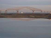
.jpg) The Francis Scott Key Bridge, viewed from Fort Armistead Park | |
| Coordinates | 39°13′09″N 76°31′31″W / 39.2192°N 76.5253°WCoordinates: 39°13′09″N 76°31′31″W / 39.2192°N 76.5253°W |
| Carries |
4 lanes of |
| Crosses | Patapsco River |
| Locale | Baltimore, Maryland |
| Maintained by | Maryland Transportation Authority |
| Characteristics | |
| Design | Steel Arch-Shaped Continuous Through Truss Bridge |
| Material | Steel |
| Total length | 8,636 feet (2,632.3 m; 1.6 mi) |
| Longest span | 1,200 feet (366 m) |
| Clearance above | 185 feet[1] |
| History | |
| Construction begin | 1972[2] |
| Opened | March 23, 1977 |
| Statistics | |
| Toll | $4.00 |
The Francis Scott Key Bridge, also known as the Outer Harbor Bridge or simply the Key Bridge, is a Steel Arch-Shaped Continuous Through Truss Bridge spanning the Patapsco River in Baltimore, Maryland, USA. The main span of 1,200 feet (366 m) is the third longest span of any continuous truss in the world.[3] It is also the longest bridge in the Baltimore area.
The bridge was opened in March 1977 and is named for the author of the Star Spangled Banner, Francis Scott Key. The bridge is the outermost of three toll crossings of Baltimore’s Harbor. Upon completion, the bridge structure and its approaches became the final links in Interstate 695 (the Baltimore Beltway). Despite the I-695 signage, the bridge is officially considered part of Maryland Route 695.[4][5]
The span is 1,200 feet (366 m) long and carries an estimated 11.5 million vehicles annually. This bridge is a designated hazardous materials truck route, as HAZMATs are prohibited in the two tunnels.
The Key Bridge is a toll facility operated by the Maryland Transportation Authority. The toll rate for cars as of July 1, 2013 is $4.00. The bridge is also part of the E-ZPass system, and includes two dedicated E-ZPass lanes in its toll plaza in both the northbound and southbound directions.
Background
In the 1960s, the Maryland Transportation Authority concluded there was a need for a second harbor crossing and began planning a single-tube tunnel under the Patapsco River, downstream from the Harbor Tunnel. The proposed site was between Hawkins Point and Sollers Point. Plans also were underway for a drawbridge over Curtis Creek to connect Hawkins Point to Sollers Point. (At the same time, a bridge was planned for the segment of I-95 that would run through the city near Fort McHenry; this was replaced by what is now known as the Fort McHenry Tunnel, a four-tube facility that opened in 1985.)
Contractors took bearings of the harbor bottom in the spring of 1969. Bids for construction of the proposed tunnel were opened on July 30, 1970, but price proposals were substantially higher than the engineering estimates. Officials drafted alternative plans, including the concept of a four-lane bridge.
The bridge, at an estimated cost of $110 (USD) million, represented the best alternative because it allowed for more traffic lanes and carried lower operating and maintenance costs than a tunnel. In addition, a bridge would provide a route across the Baltimore Harbor for vehicles transporting hazardous materials (these materials are prohibited from both the Baltimore Harbor and Fort McHenry tunnels).
Construction began in 1972, and the bridge opened to traffic on March 23, 1977. Including its connecting approaches, the bridge project is 10.9 miles (17.54 km) in length. Other structures along the thruway include a 0.64-mile (1.03 km) dual-span drawbridge over Curtis Creek and two 0.74-mile (1.19 km) parallel bridge structures that carry traffic over Bear Creek, near the former Bethlehem Steel Sparrows Point plant, this portion of the project not being fully complete until the late 1990s.
Located in an area rich with American history, scholars believe the span crosses within 100 yards (91 m) of the site, marked in the water off the bridge by a stars and striped painted buoy, where Francis Scott Key witnessed the bombardment of Fort McHenry on the evening of September 12, 1814. That battle inspired Key to write the words of the Star Spangled Banner. Located just southeast of the bridge are the ruins of Fort Carroll.
There is another bridge called the Francis Scott Key Bridge, located in Washington, DC on US 29. It crosses the Potomac River, and links the District to Arlington, Virginia.
See also
-
 Bridges portal
 -
 Maryland portal
 -
 Baltimore portal
References
- ↑ http://www.roadstothefuture.com/Balt_Outer_Harbor.html
- ↑ Francis Scott Key Bridge at Structurae
- ↑ Durkee, Jackson, World's Longest Bridge Spans, National Steel Bridge Alliance, May 24, 1999.
- ↑ Maryland State Highway Administration (2007). "Highway Location Reference: Baltimore County" (PDF). Retrieved 2009-04-15.
- ↑ Maryland State Highway Administration (2005). "Highway Location Reference: Baltimore City" (PDF). Archived from the original (PDF) on March 20, 2009. Retrieved 2009-04-15.
External links
| Wikimedia Commons has media related to Francis Scott Key Bridge (Baltimore). |
- Maryland Transportation Authority, Francis Scott Key Bridge website
- Steve Anderson's DCroads.net: Francis Scott Key Bridge (I-695)
| Crossings of the Patapsco River | ||||
|---|---|---|---|---|
| ||||
| Highways | |
|---|---|
| Railroads | |