Fulda (river)
| Fulda | |
|---|---|
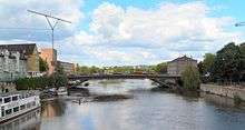 The Fulda in Kassel | |
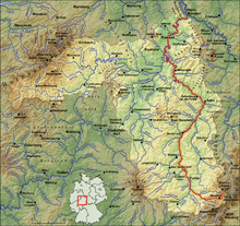 Course of the Fulda shown in red | |
| Country | Germany |
| Basin | |
| Main source |
Rhön 850 m (2,790 ft) 50°29′40″N 9°56′42″E / 50.49444°N 9.94500°E |
| River mouth |
Weser 51°25′16″N 9°38′54″E / 51.42111°N 9.64833°ECoordinates: 51°25′16″N 9°38′54″E / 51.42111°N 9.64833°E |
| Progression | Weser→ North Sea |
| Basin size | 6,932 km2 (2,676 sq mi) |
| Physical characteristics | |
| Length | 220.7 km (137.1 mi) |
The Fulda (German pronunciation: [ˈfʊlda]) is a river in Hesse, Germany. It is one of two headstreams of the Weser (the other one being the Werra). The Fulda is 220.7 kilometres (137.1 mi) long.
The river arises at Wasserkuppe in the Rhön mountains. From there it runs northeast, flanked by the Knüll mountains in the west and the Seulingswald in the east. Near Bebra it changes direction to the northwest.
After joining the Eder river it flows straight north until Kassel, then changes direction to the northeast, with the Kaufungen Forest east and the beginning of the Reinhardswald forest northwest. The north end of the river meets the Werra in Hannoversch Münden, where the Fulda and the Werra join to form the Weser river.
Cities along the Fulda include:
External links
![]() Media related to Fulda (river) at Wikimedia Commons
Media related to Fulda (river) at Wikimedia Commons
- Flight near Fulda Videoclip (10 MB, 1:20 min) from the German site http://www.osthessen-news.de