Funny River Fire
| Funny River Fire | |
|---|---|
|
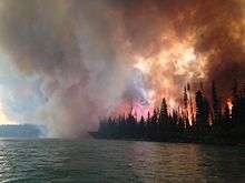
Flames rage adjacent to the river on May 25. | |
| Location | Soldotna, Alaska |
| Coordinates | 60°26′20″N 150°57′43″W / 60.439°N 150.962°W |
| Statistics | |
| Date(s) | May 19, 2014 – ??? |
| Burned area | 193,597 acres (783 km2) |
| Map | |
 | |
The Funny River Fire or the Funny River Horse Trail Fire was a forest fire that began on May 19, 2014 near Soldotna, Alaska. It quickly grew to over 20,000 acres, and by May 23 it had burned over 67,000 acres or about 105 square miles. Tustumena Lake acted as a natural barrier keeping the fire from spreading south. A July 10 overflight found no sign of the fire continuing to burn. It had grown to 195,858 acres.[1]
As of May 23, 2014 the entire fire was confined to the Kenai National Wildlife Refuge.[2] On May 24 the fire had expanded to 96,584 acres or about 151 square miles with 20% containment.[3] The fire grew by almost 29 square miles between 5:00 PM and 11:00 PM on the evening of the 23rd.[4]
The fire started approximately where the Funny River Horse Trail intersects the Funny River Road on the Kenai Peninsula at about 7:00 PM and was likely human-caused.[5]
The fire had consumed 156,041 acres or 243 square miles as of 4:00 PM Alaska Time of May 25.[6] It jumped the Kenai River in the Torpedo Lake area between Sterling and Skilak Lake due to burning embers that had fallen in the Kenai Keys area, but these were quickly extinguished. There were several evacuation orders in effect including areas of Kasilof, Sterling, and Lower Skilak Lake.[7]
References
- ↑ "Reconnaissance flight made of the Funny River Fire". July 10, 2014.
- ↑ "Funny River Fire grows to 105 square miles".
- ↑ "As Funny River evacuations lifted, investigators seek public's insight into cause".
- ↑ "Fire escapes burn barrel, ignites first Mat-Su wildfire of the season".
- ↑ "InciWeb the Incident Information System: Funny River Fire". InciWeb.
- ↑ Associated Press. "Funny River Fire: Alaska fire grows to 243 square miles". KNXV.
- ↑ "Security Check Required".