Futuna (Wallis and Futuna)

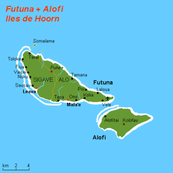
with Futuna Island in the northwest

Futuna (/fuːˈtuːnə/; French: [fy.ty.na]) is an 80 km2 island with 5,000 people and max. elevation of 500 m in the Pacific Ocean, belonging to the French overseas collectivity (collectivité d'outre-mer, or COM) of Wallis and Futuna. It is one of the Hoorn Islands or Îles Horne, nearby Alofi being the other. They are both a remnant of an old extinct volcano, now bordered with a fringing reef.
The island is famous as the place (where the cathedral of Poi now stands) where Pierre Chanel was martyred in 1841, becoming Polynesia's one and only Catholic saint. Futuna takes its name from an endonym derived from the local futu, fish-poison tree.
Geography
The population is 4,871 (census of 2003), of which 2,991 reside in Alo and 1,880 in Sigave. Futuna's highest point is Mont Puke with 524 m, and the island has an area of 83 km², with 53 km² in Sigave and 30 km² in Alo (Alo).
History
Futuna and Alofi were put on the European maps by Willem Schouten and Jacob Le Maire during their famous circumnavigation of the globe with the ship the Eendracht in 1616. After having come from Niuafoʻou, they suddenly changed their course from west to northwest and so stumbled on this island pair. They called it Hoorn Eylanden, after the city of Hoorn, Schouten's birthplace, which became Horne in both French and English. Wise from their earlier experiences, they started with a show of force to the natives who approached them, which resulted in a peaceful barter with coconuts, yams and hogs from one side and iron nails, beads and knives from the other. They found a beautiful bay, a natural harbour along the southwest coast of Futuna, which they called after the ship the Eendrachts baai (Unity bay). This must be the Anse de Sigave near Leava of today. They went ashore on to get water and met the king, who told his subjects that their guests were not to be disturbed by petty thieving. In this amiable way the Dutch were able to replenish their stocks. A few days later the king of the other island, Alofi, came to visit with 300 men. The two kings were extremely courteous to each other, and a big feast was prepared. A kava ceremony and ʻumu were organised. Schouten and LeMaire were probably the first Europeans ever to witness these, and the description they gave still rings familiar tones nowadays.
Not having been bothered by thieving and hostilities, Schouten and LeMaire had the opportunity to study Futuna a little bit more carefully than the Niua islands. (They did not go to Alofi). But their description of the islanders is not flattering. Although they praise the men for being well proportioned, the women they found ugly, ill-shaped with breasts hanging down to their bellies as empty satchels. They all went naked and copulated in public, even in front of their revered king.
Culture

Two kings, elected from the local nobility every few years, rule the population in conjunction with French authorities. They are the king of Sigave, the western province, and the king of Alo, the eastern province including Alofi. Except for Poi all villages are along the southwest coast, and they are from west to east: Toloke, Fiua, Vaisei, Nuku, and Leava (capital with the wharf) in Sigave, and Taoa, Malaʻe, Ono, Kolia and Vele (at the airstrip) in Alo.
As on ʻUvea, all Futunans are deeply religious Catholic and the number of churches, chapels and oratories is overwhelming. Although the island is closer to Tonga and farther from Sāmoa than ʻUvea, the vernacular and culture are more Sāmoan. The languages spoken are Futunan and French.
Education
There are six primary schools on Futuna.[1] The island also has two junior high schools (collèges): Fiua de Sigave and Sisia d'Ono. Residents are served by a senior high school/sixth-form college, Lycée d'Etat de Wallis et Futuna, on Wallis.[2]
See also
References
- ↑ "LIVRET D'ACCUEIL Wallis et Futuna." Wallis and Futuna. p. 22 (22/28). Retrieved on September 14, 2016.
- ↑ "Cartographie des établissements du second degré." Wallis and Futuna. June 24, 2016. Retrieved on September 14, 2016.
References
- Cartes institut géographique national (4902F)
- Robert Kerr (1824): Voyage round the world, in 1615-1617, by William Cornelison Schouten and Jacques le Maire, going round Cape Horn. The comments of the editor to the original ship's journals are completely wrong, however.
- Percy Smith (1892): "Futuna; or, Horne Island and its People", Journal of the Polynesian Society, vol.1, pp. 33–52
Coordinates: 14°17′S 178°09′W / 14.283°S 178.150°W
