Galinoporni
| Galinoporni | |
|---|---|
|
View of the Turkish Cypriot village of Galinoporni/Kaleburnu in 2016 | |
 Galinoporni | |
| Coordinates: 35°31′21″N 34°18′07″E / 35.52250°N 34.30194°ECoordinates: 35°31′21″N 34°18′07″E / 35.52250°N 34.30194°E | |
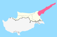
| Country |
|
| • District | Famagusta District |
| Country (controlled by) |
|
| • District | İskele District |
| Population (2011)[1] | |
| • Total | 333 |

Galinoporni (Greek: Γαληνόπορνη; Turkish: Kaleburnu) is a Turkish Cypriot village in Cyprus, located on the southern side of the Karpas Peninsula. Galinoporni is under the de facto control of Northern Cyprus. As of 2011, it had a population of 333. The village is attended in the summer months by wealthy Turkish Cypriots, who expatriated in England and let build in Kaleburnu their summer residences.[2] Although the inhabitants' religion is Islam, the population's language was Greek, and only after 1974 Turkish could gradually take foot among the villagers.[2]
The surroundings of the village host two bronze age sites: in Kraltepe the remains of a palace have been excavated, whose dwellers had trade contacts with the eastern coast of the Mediterranean sea around 1200 BC.[2] In Nitovikla there is a fortress dating back to 1500 BC, whose citadel has been erected in the style of the Hittitian fortress of Boğazköy in Anatolia.[2] Moreover, in Avtepe there is an important group of caves, which host architectonic remains.[2]